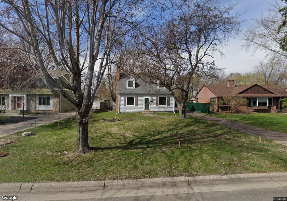
1379 Roselawn Ave W Saint Paul, MN 55113
Roselawn NeighborhoodEstimated Value: $390,000 - $417,000
4
Beds
2
Baths
1,764
Sq Ft
$231/Sq Ft
Est. Value
About This Home
This home is located at 1379 Roselawn Ave W, Saint Paul, MN 55113 and is currently estimated at $407,273, approximately $230 per square foot. 1379 Roselawn Ave W is a home located in Ramsey County with nearby schools including Falcon Heights Elementary, Roseville Area Middle School, and Roseville Area Senior High School.
Ownership History
Date
Name
Owned For
Owner Type
Purchase Details
Closed on
Oct 18, 2021
Sold by
Becker Stephanie C
Bought by
Brandyold Phillip and Brandyold Bethany
Current Estimated Value
Home Financials for this Owner
Home Financials are based on the most recent Mortgage that was taken out on this home.
Original Mortgage
$297,000
Interest Rate
2.35%
Mortgage Type
New Conventional
Purchase Details
Closed on
Apr 20, 2017
Sold by
Becker Paul C
Bought by
Becker Stephanie C
Purchase Details
Closed on
Dec 13, 2002
Sold by
Borgstrom Carl L and Borgstrom Dorothy S
Bought by
Becker Paul C and Becker Stephanie C
Purchase Details
Closed on
May 23, 2002
Sold by
Estate Of Betty B Canaday
Bought by
Borgstrom Carl L and Borgstrom Dorothy S
Create a Home Valuation Report for This Property
The Home Valuation Report is an in-depth analysis detailing your home's value as well as a comparison with similar homes in the area
Home Values in the Area
Average Home Value in this Area
Purchase History
| Date | Buyer | Sale Price | Title Company |
|---|---|---|---|
| Brandyold Phillip | $330,000 | Burnet Title | |
| Becker Stephanie C | -- | None Available | |
| Becker Paul C | $240,000 | -- | |
| Borgstrom Carl L | $190,000 | -- |
Source: Public Records
Mortgage History
| Date | Status | Borrower | Loan Amount |
|---|---|---|---|
| Previous Owner | Brandyold Phillip | $297,000 |
Source: Public Records
Tax History Compared to Growth
Tax History
| Year | Tax Paid | Tax Assessment Tax Assessment Total Assessment is a certain percentage of the fair market value that is determined by local assessors to be the total taxable value of land and additions on the property. | Land | Improvement |
|---|---|---|---|---|
| 2025 | $4,728 | $380,100 | $99,800 | $280,300 |
| 2023 | $4,728 | $342,100 | $90,300 | $251,800 |
| 2022 | $4,018 | $339,200 | $90,300 | $248,900 |
| 2021 | $5,160 | $277,300 | $90,300 | $187,000 |
| 2020 | $5,974 | $291,200 | $76,500 | $214,700 |
| 2019 | $6,262 | $302,200 | $76,500 | $225,700 |
| 2018 | $5,038 | $284,600 | $83,000 | $201,600 |
| 2017 | $4,844 | $228,000 | $83,000 | $145,000 |
| 2016 | $4,594 | $0 | $0 | $0 |
| 2015 | $4,438 | $232,900 | $60,500 | $172,400 |
| 2014 | $4,270 | $0 | $0 | $0 |
Source: Public Records
Map
Nearby Homes
- 57X Roselawn Ave W
- 1446 Shryer Ave W
- 1455 Shryer Ave W
- 1265 Shryer Ave W
- 1150 Summer St
- 692 Skillman Ave W
- 1116 Roselawn Ave W
- 1776 Saint Marys St
- 1609 Huron St
- 1615 Chelsea St
- 1620 County Road B W
- 1624 County Road B W
- 1836 Hamline Ave N
- 1031 Ryan Ave W
- 1541 Hamline Ave N
- 1529 Hamline Ave N
- 204X Eldridge Ave W
- 1544 Asbury St
- 1507 Holton St
- 1008 Burke Ave W
- 1383 Roselawn Ave W
- 1367 Roselawn Ave W
- 1385 Roselawn Ave W
- 1363 Roselawn Ave W
- 1913 Sheldon St
- 1357 Roselawn Ave W
- 1912 Sheldon St
- 1401 Roselawn Ave W
- 1905 Sheldon St
- 1906 1906 Sheldon-Street-
- 1905 1905 Sheldon St
- 1941 Hamline Ave N
- 1935 Hamline Ave N
- 1906 Sheldon St
- 1947 Hamline Ave N
- 1906 Albert St N
- 1913 Hamline Ave N
- 1897 1897 Sheldon St
- 1897 Sheldon St
- 1896 1896 Sheldon St