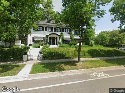
1404 W Franklin Ave Minneapolis, MN 55405
Lowry Hill NeighborhoodEstimated Value: $817,000 - $1,045,000
5
Beds
4
Baths
3,928
Sq Ft
$241/Sq Ft
Est. Value
About This Home
This home is located at 1404 W Franklin Ave, Minneapolis, MN 55405 and is currently estimated at $947,074, approximately $241 per square foot. 1404 W Franklin Ave is a home located in Hennepin County with nearby schools including Kenwood Elementary School, Anwatin Middle School, and North Community High School.
Ownership History
Date
Name
Owned For
Owner Type
Purchase Details
Closed on
Nov 26, 2013
Sold by
Appleman Michael A and Appleman Michelle K
Bought by
1404 Franklin Llc
Current Estimated Value
Home Financials for this Owner
Home Financials are based on the most recent Mortgage that was taken out on this home.
Original Mortgage
$402,500
Interest Rate
4.5%
Mortgage Type
New Conventional
Create a Home Valuation Report for This Property
The Home Valuation Report is an in-depth analysis detailing your home's value as well as a comparison with similar homes in the area
Home Values in the Area
Average Home Value in this Area
Purchase History
| Date | Buyer | Sale Price | Title Company |
|---|---|---|---|
| 1404 Franklin Llc | -- | None Available |
Source: Public Records
Mortgage History
| Date | Status | Borrower | Loan Amount |
|---|---|---|---|
| Previous Owner | Appleman Michael | $402,500 | |
| Previous Owner | Appleman Michael A | $100,000 | |
| Previous Owner | Appleman Michael | $400,000 |
Source: Public Records
Tax History Compared to Growth
Tax History
| Year | Tax Paid | Tax Assessment Tax Assessment Total Assessment is a certain percentage of the fair market value that is determined by local assessors to be the total taxable value of land and additions on the property. | Land | Improvement |
|---|---|---|---|---|
| 2023 | $12,753 | $701,000 | $264,000 | $437,000 |
| 2022 | $13,349 | $701,000 | $264,000 | $437,000 |
| 2021 | $10,482 | $714,000 | $254,000 | $460,000 |
| 2020 | $11,073 | $713,500 | $241,500 | $472,000 |
| 2019 | $11,704 | $713,500 | $217,000 | $496,500 |
| 2018 | $10,505 | $713,500 | $217,000 | $496,500 |
| 2017 | $10,704 | $660,500 | $197,300 | $463,200 |
| 2016 | $11,040 | $660,500 | $197,300 | $463,200 |
| 2015 | $11,577 | $660,500 | $197,300 | $463,200 |
| 2014 | -- | $629,000 | $180,200 | $448,800 |
Source: Public Records
Map
Nearby Homes
- 1909 Fremont Ave S Unit 201
- 2120 Girard Ave S
- 2104 Emerson Ave S
- 2112 Emerson Ave S Unit 3
- 1901 Emerson Ave S Unit 208
- 1940 Dupont Ave S
- 2204 Girard Ave S
- 1912 Dupont Ave S Unit 302
- 1912 Dupont Ave S Unit 202
- 1801 Fremont Ave S Unit 101
- 2000 Irving Ave S
- 1941 James Ave S
- 1617 W Franklin Ave
- 1767 Girard Ave S
- 2225 Irving Ave S Unit 2
- 1767 Fremont Ave S
- 1807 Dupont Ave S
- 1770 Humboldt Ave S Unit 1
- 1308 W 24th St
- 1121 Douglas Ave
- 1404 W Franklin Ave
- 1930 Girard Ave S
- 2000 Girard Ave S
- 1939 Humboldt Ave S
- 1933 Humboldt Ave S
- 1929 Humboldt Ave S
- 1920 Girard Ave S
- 2006 Girard Ave S
- 1925 Humboldt Ave S
- 1415 W Franklin Ave
- 1935 Girard Ave S
- 2008 Girard Ave S
- 1931 Girard Ave S Unit 2
- 1929 Girard Ave S Unit 1
- 1937 Girard Ave S Unit 1937
- 1421 W Franklin Ave
- 1921 Humboldt Ave S
- 1921 Humboldt Ave S Unit 1
- 2009 Humboldt Ave S
- 1925 Girard Ave S