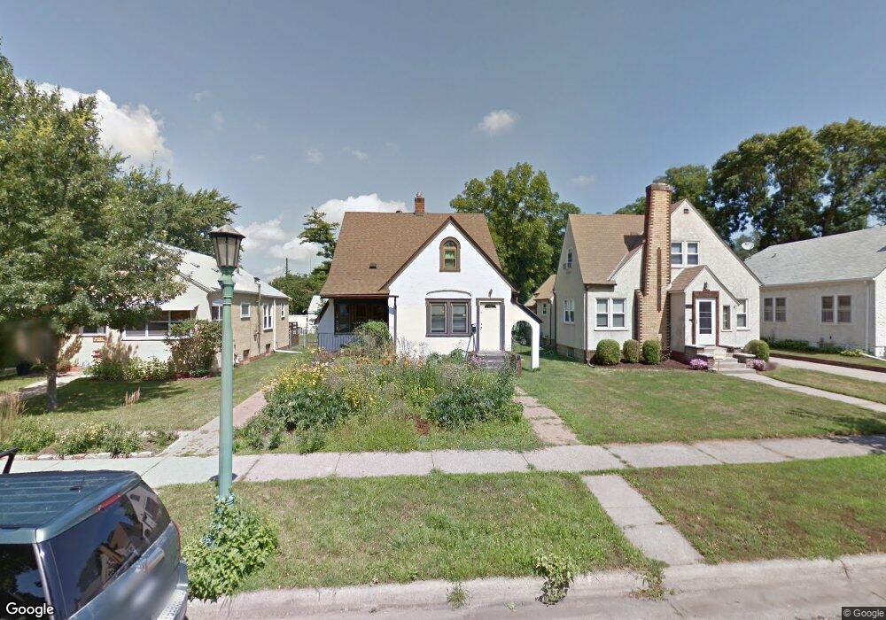
1407 Hubbard Ave Saint Paul, MN 55104
Hamline-Midway NeighborhoodEstimated Value: $318,000 - $440,000
4
Beds
2
Baths
1,888
Sq Ft
$201/Sq Ft
Est. Value
About This Home
This home is located at 1407 Hubbard Ave, Saint Paul, MN 55104 and is currently estimated at $380,230, approximately $201 per square foot. 1407 Hubbard Ave is a home located in Ramsey County with nearby schools including Hancock/Hamline Magnet Elementary School, Murray Middle School, and Como Park Senior High School.
Ownership History
Date
Name
Owned For
Owner Type
Purchase Details
Closed on
Jul 29, 2021
Sold by
Mccall Susan D
Bought by
Skipper Llc
Current Estimated Value
Purchase Details
Closed on
Jun 1, 2016
Sold by
Granlund Mark Jay
Bought by
Mccall Susan D
Home Financials for this Owner
Home Financials are based on the most recent Mortgage that was taken out on this home.
Original Mortgage
$228,937
Interest Rate
3.66%
Mortgage Type
FHA
Purchase Details
Closed on
Jul 16, 2001
Sold by
Poul Thomas J
Bought by
Records Peggy I
Create a Home Valuation Report for This Property
The Home Valuation Report is an in-depth analysis detailing your home's value as well as a comparison with similar homes in the area
Home Values in the Area
Average Home Value in this Area
Purchase History
| Date | Buyer | Sale Price | Title Company |
|---|---|---|---|
| Skipper Llc | $360,000 | Results Title | |
| Mccall Susan D | $250,000 | Titlesmart Inc | |
| Records Peggy I | $239,100 | -- | |
| -- | $360,000 | -- |
Source: Public Records
Mortgage History
| Date | Status | Borrower | Loan Amount |
|---|---|---|---|
| Previous Owner | Mccall Susan D | $228,937 |
Source: Public Records
Tax History Compared to Growth
Tax History
| Year | Tax Paid | Tax Assessment Tax Assessment Total Assessment is a certain percentage of the fair market value that is determined by local assessors to be the total taxable value of land and additions on the property. | Land | Improvement |
|---|---|---|---|---|
| 2025 | $6,786 | $385,700 | $28,300 | $357,400 |
| 2023 | $6,786 | $350,300 | $28,300 | $322,000 |
| 2022 | $5,698 | $350,300 | $28,300 | $322,000 |
| 2021 | $4,832 | $283,200 | $28,300 | $254,900 |
| 2020 | $4,476 | $265,400 | $28,300 | $237,100 |
| 2019 | $3,910 | $263,000 | $28,300 | $234,700 |
| 2018 | $4,680 | $229,000 | $28,300 | $200,700 |
| 2017 | $3,668 | $219,100 | $28,300 | $190,800 |
| 2016 | $3,690 | $0 | $0 | $0 |
| 2015 | $3,402 | $165,000 | $28,300 | $136,700 |
| 2014 | $2,592 | $0 | $0 | $0 |
Source: Public Records
Map
Nearby Homes
- 1437 Englewood Ave
- 1434 Minnehaha Ave W
- 1391 Van Buren Ave
- 708 Hamline Ave N
- 1294 Hubbard Ave
- 1527 Minnehaha Ave W
- 1473 Blair Ave
- 1292 Taylor Ave W
- 1470 Blair Ave
- 1515 Blair Ave
- 1310 Blair Ave
- 1506 Blair Ave
- 1236 Hubbard Ave
- 1557 Blair Ave
- 641 Asbury St
- 1258 Blair Ave
- 1595 Blair Ave
- 1636 Minnehaha Ave W
- 1391 Charles Ave
- 1215 Lafond Ave
- 1409 Hubbard Ave
- 1407-1409 Hubbard Ave
- 1403 Hubbard Ave
- 1397 Hubbard Ave
- 1411 Hubbard Ave
- 804 Holton St
- 803 Albert St N
- 808 Holton St
- 807 Albert St N
- 812 Holton St
- 811 Albert St N
- 819 Albert St N
- 1408 Hubbard Ave
- 1404 Hubbard Ave
- 800 Holton St
- 797 Albert St N
- 1400 Hubbard Ave
- 1412 Hubbard Ave
- 816 Holton St
- 794 Holton St