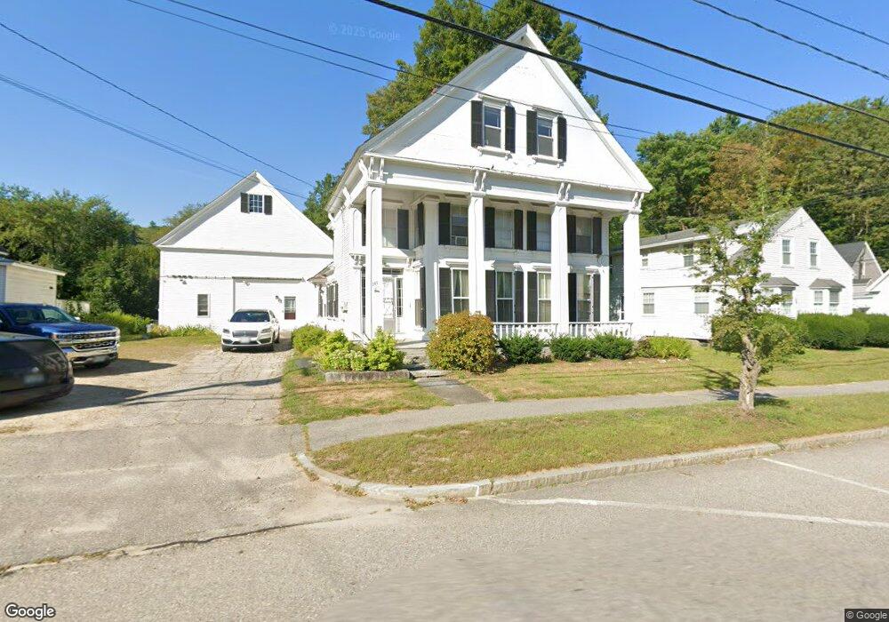
141 Main St Marlborough, NH 03455
Estimated Value: $306,000 - $489,874
6
Beds
3
Baths
2,581
Sq Ft
$158/Sq Ft
Est. Value
About This Home
This home is located at 141 Main St, Marlborough, NH 03455 and is currently estimated at $407,219, approximately $157 per square foot. 141 Main St is a home with nearby schools including Marlborough Elementary School, Mayland Early College High School, and Keene High School.
Ownership History
Date
Name
Owned For
Owner Type
Purchase Details
Closed on
Dec 18, 2024
Sold by
Norris Darlene D
Bought by
Norris Darlene D and Norris John D
Current Estimated Value
Purchase Details
Closed on
Aug 27, 2015
Sold by
Harde Michael B
Bought by
Norris Darlene D
Purchase Details
Closed on
Jun 18, 1998
Sold by
Gordon John E and Gordon Elizabeth B
Bought by
Harde Michael B and Harde Darlene D
Home Financials for this Owner
Home Financials are based on the most recent Mortgage that was taken out on this home.
Original Mortgage
$92,000
Interest Rate
7.09%
Create a Home Valuation Report for This Property
The Home Valuation Report is an in-depth analysis detailing your home's value as well as a comparison with similar homes in the area
Home Values in the Area
Average Home Value in this Area
Purchase History
| Date | Buyer | Sale Price | Title Company |
|---|---|---|---|
| Norris Darlene D | -- | None Available | |
| Norris Darlene D | -- | -- | |
| Norris Darlene D | -- | -- | |
| Harde Michael B | $115,000 | -- | |
| Harde Michael B | $115,000 | -- |
Source: Public Records
Mortgage History
| Date | Status | Borrower | Loan Amount |
|---|---|---|---|
| Previous Owner | Harde Michael B | $92,000 |
Source: Public Records
Tax History Compared to Growth
Tax History
| Year | Tax Paid | Tax Assessment Tax Assessment Total Assessment is a certain percentage of the fair market value that is determined by local assessors to be the total taxable value of land and additions on the property. | Land | Improvement |
|---|---|---|---|---|
| 2024 | $5,661 | $197,050 | $34,400 | $162,650 |
| 2023 | $4,843 | $197,050 | $34,400 | $162,650 |
| 2022 | $5,145 | $197,050 | $34,400 | $162,650 |
| 2021 | $4,907 | $197,050 | $34,400 | $162,650 |
| 2020 | $5,850 | $221,960 | $29,100 | $192,860 |
| 2019 | $6,985 | $221,960 | $29,100 | $192,860 |
| 2018 | $7,362 | $221,960 | $29,100 | $192,860 |
| 2016 | $6,699 | $221,960 | $29,100 | $192,860 |
| 2015 | $6,879 | $242,990 | $36,360 | $206,630 |
| 2013 | $6,476 | $242,990 | $36,360 | $206,630 |
Source: Public Records
Map
Nearby Homes
- 26 Terrace St
- 89 Main St
- 40 Jaffrey Rd
- 16 Jewett St
- 0 State Route 101 Unit 5004128
- 00 Graves Rd
- 00 Monadnock Hwy
- 126 Monadnock Hwy
- 658 Main St
- 269 Branch Rd
- 15 Waters Edge Rd
- 4 Middletown Rd
- 66 Sugar Hill Rd
- 0 Optical Ave
- 64 Old Homestead Hwy
- 471 Chapman Rd
- 46 Belmont Ave
- 22 Fairfield Ct
- 194 Marlboro St
- 15 Jennison St