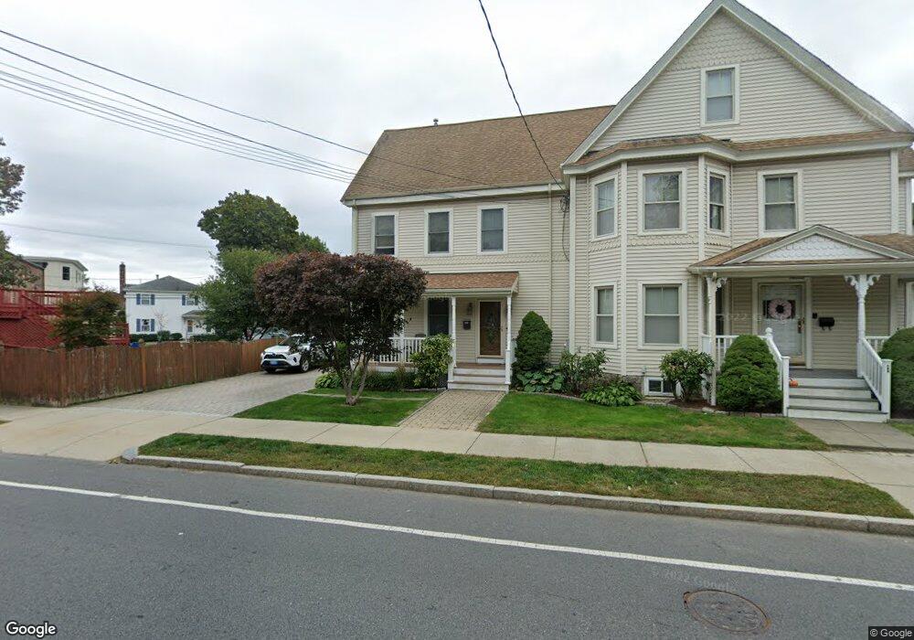
142 River St West Newton, MA 02465
West Newton NeighborhoodEstimated Value: $789,000 - $926,000
3
Beds
3
Baths
1,651
Sq Ft
$521/Sq Ft
Est. Value
About This Home
This home is located at 142 River St, West Newton, MA 02465 and is currently estimated at $859,426, approximately $520 per square foot. 142 River St is a home located in Middlesex County with nearby schools including C.C. Burr, F.A. Day Middle School, and Newton North High School.
Ownership History
Date
Name
Owned For
Owner Type
Purchase Details
Closed on
Mar 14, 2008
Sold by
Mastroianni Antonio and Mastroianni Maria
Bought by
Mastroianni Michael
Current Estimated Value
Home Financials for this Owner
Home Financials are based on the most recent Mortgage that was taken out on this home.
Original Mortgage
$120,000
Interest Rate
5.72%
Mortgage Type
Purchase Money Mortgage
Purchase Details
Closed on
Jul 29, 2004
Sold by
Conway Joseph A
Bought by
Mastroianni Antonio and Mastroianni Maria
Purchase Details
Closed on
Nov 26, 1996
Sold by
Sbardelli Rose M
Bought by
Conway Joseph A
Create a Home Valuation Report for This Property
The Home Valuation Report is an in-depth analysis detailing your home's value as well as a comparison with similar homes in the area
Home Values in the Area
Average Home Value in this Area
Purchase History
| Date | Buyer | Sale Price | Title Company |
|---|---|---|---|
| Mastroianni Michael | $133,500 | -- | |
| Mastroianni Michael | $133,500 | -- | |
| Mastroianni Michael | $133,500 | -- | |
| Mastroianni Antonio | $465,000 | -- | |
| Mastroianni Antonio | $465,000 | -- | |
| Conway Joseph A | $225,000 | -- | |
| Conway Joseph A | $225,000 | -- |
Source: Public Records
Mortgage History
| Date | Status | Borrower | Loan Amount |
|---|---|---|---|
| Open | Conway Joseph A | $150,000 | |
| Closed | Conway Joseph A | $15,000 | |
| Closed | Mastroianni Michael | $120,000 |
Source: Public Records
Tax History Compared to Growth
Tax History
| Year | Tax Paid | Tax Assessment Tax Assessment Total Assessment is a certain percentage of the fair market value that is determined by local assessors to be the total taxable value of land and additions on the property. | Land | Improvement |
|---|---|---|---|---|
| 2025 | $6,992 | $713,500 | $0 | $713,500 |
| 2024 | $6,761 | $692,700 | $0 | $692,700 |
| 2023 | $6,567 | $645,100 | $0 | $645,100 |
| 2022 | $6,463 | $614,400 | $0 | $614,400 |
| 2021 | $6,236 | $579,600 | $0 | $579,600 |
| 2020 | $6,051 | $579,600 | $0 | $579,600 |
| 2019 | $5,880 | $562,700 | $0 | $562,700 |
| 2018 | $5,880 | $543,400 | $0 | $543,400 |
| 2017 | $5,700 | $512,600 | $0 | $512,600 |
| 2016 | $5,452 | $479,100 | $0 | $479,100 |
| 2015 | $5,298 | $456,300 | $0 | $456,300 |
Source: Public Records
Map
Nearby Homes
- 106 River St Unit 18
- 106 River St Unit 2
- 106 River St Unit 14
- 2 Elm St Unit 6
- 2 Elm St Unit 8
- 44 Westland Ave
- 42 Evergreen Cir
- 212 River St Unit 2
- 371 Cherry St
- 90 Auburndale Ave
- 56 Dearborn St
- 287 Cherry St Unit 2
- 33 Lill Ave
- 41 Kilburn Rd
- 66 Webster St
- 265-267 River St Unit 267
- 265-267 River St Unit 265
- 429 Cherry St Unit 11
- 10 Crescent St Unit 1
- 10 Crescent St Unit 2
- 142 River St Unit 144
- 144 River St
- 146 River St
- 19 Auburndale Ave Unit 19
- 17 Auburndale Ave Unit B
- 17 Auburndale Ave Unit 19
- 19 Auburndale Ave Unit 2
- 17 Auburndale Ave Unit 17
- 11 Auburn St
- 25 Auburndale Ave Unit 25
- 25 Auburndale Ave Unit B
- 25 Auburndale Ave
- 5 Auburn St Unit 5
- 5 Auburn St
- 23 Auburndale Ave
- 23 Auburndale Ave Unit 1
- 23 Auburndale Ave Unit A
- 23 Auburndale Ave Unit 23
- 150 River St Unit 152
- 143 River St Unit 2