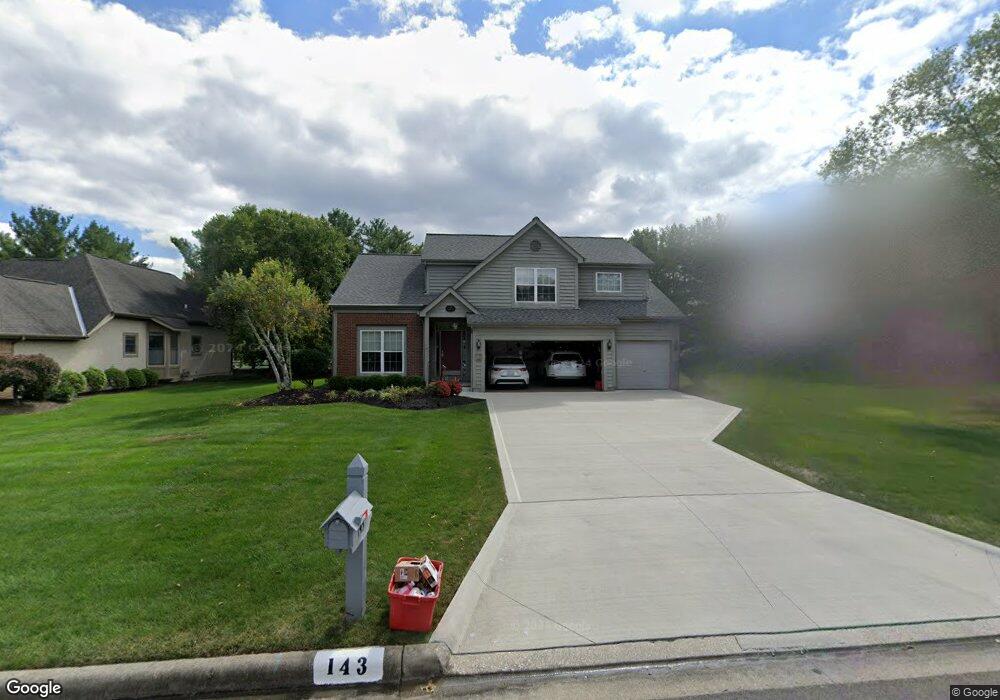
143 Wallsend Ct Powell, OH 43065
Estimated Value: $532,000 - $644,000
4
Beds
3
Baths
2,650
Sq Ft
$225/Sq Ft
Est. Value
About This Home
This home is located at 143 Wallsend Ct, Powell, OH 43065 and is currently estimated at $597,428, approximately $225 per square foot. 143 Wallsend Ct is a home located in Delaware County with nearby schools including Tyler Run Elementary School, Olentangy Liberty Middle School, and Olentangy Liberty High School.
Ownership History
Date
Name
Owned For
Owner Type
Purchase Details
Closed on
May 15, 2015
Sold by
Shepard Donald R and Shepard Georgia A
Bought by
Shepard Donald R and Shepard Georgia A
Current Estimated Value
Purchase Details
Closed on
May 22, 1998
Sold by
Meier Angie F
Bought by
Shepard Donald R and Shepard Georgia A
Home Financials for this Owner
Home Financials are based on the most recent Mortgage that was taken out on this home.
Original Mortgage
$135,000
Interest Rate
6.84%
Mortgage Type
New Conventional
Create a Home Valuation Report for This Property
The Home Valuation Report is an in-depth analysis detailing your home's value as well as a comparison with similar homes in the area
Home Values in the Area
Average Home Value in this Area
Purchase History
| Date | Buyer | Sale Price | Title Company |
|---|---|---|---|
| Shepard Donald R | -- | Attorney | |
| Shepard Donald R | $215,000 | -- |
Source: Public Records
Mortgage History
| Date | Status | Borrower | Loan Amount |
|---|---|---|---|
| Previous Owner | Shepard Donald R | $135,000 |
Source: Public Records
Tax History
| Year | Tax Paid | Tax Assessment Tax Assessment Total Assessment is a certain percentage of the fair market value that is determined by local assessors to be the total taxable value of land and additions on the property. | Land | Improvement |
|---|---|---|---|---|
| 2024 | $8,224 | $166,750 | $36,580 | $130,170 |
| 2023 | $8,289 | $166,750 | $36,580 | $130,170 |
| 2022 | $7,421 | $120,610 | $24,500 | $96,110 |
| 2021 | $7,549 | $120,610 | $24,500 | $96,110 |
| 2020 | $7,576 | $120,610 | $24,500 | $96,110 |
| 2019 | $6,486 | $108,080 | $24,500 | $83,580 |
| 2018 | $6,561 | $108,080 | $24,500 | $83,580 |
| 2017 | $6,607 | $100,800 | $20,370 | $80,430 |
| 2016 | $6,524 | $100,800 | $20,370 | $80,430 |
| 2015 | $5,937 | $100,800 | $20,370 | $80,430 |
| 2014 | $6,016 | $100,800 | $20,370 | $80,430 |
| 2013 | $6,000 | $98,460 | $20,370 | $78,090 |
Source: Public Records
Map
Nearby Homes
- 1937 Liberty St
- 120 S Liberty St
- 97 Murphys Crossing Dr
- 130 Barrington Place
- 424 Whitaker Ave S
- 18 Murphys View Place Unit I18
- 170 Barrington Place
- 149 Chedworth Row
- 104 Encore Park Bend
- 255 Winter Hill Place
- 86 Cressingham Ln
- 471 Commons Dr Unit 471
- 149 Trail Edge Cir
- 269 Ridge Side Dr
- 22 Brookehill Dr
- 22 Liberty Ridge Ave
- 5552 Jessica Ln W
- 9406 Cadogan Ct
- 2672 Sawmill Reserve Dr Unit 2672
- 8292 Breckenridge Way
- 135 Wallsend Ct
- 155 Wallsend Ct
- 1164 Wallsend Ct
- 167 Wallsend Ct
- 125 Wallsend Ct
- 142 Wallsend Ct
- 130 Wallsend Ct
- 152 Wallsend Ct
- 177 Wallsend Ct
- 115 Wallsend Ct
- 120 Wallsend Ct
- 164 Wallsend Ct
- 140 Whitegate Ct
- 110 Wallsend Ct
- 139 Whitegate Ct
- 174 Wallsend Ct
- 187 Wallsend Ct
- 105 Wallsend Ct
- 259 Oquinn Ct
- 267 Oquinn Ct
Your Personal Tour Guide
Ask me questions while you tour the home.