
Seller's Agent in 2025
Wanda Mooney
Coldwell Banker Community REALTORS®
(413) 768-9848
16 in this area
224 Total Sales
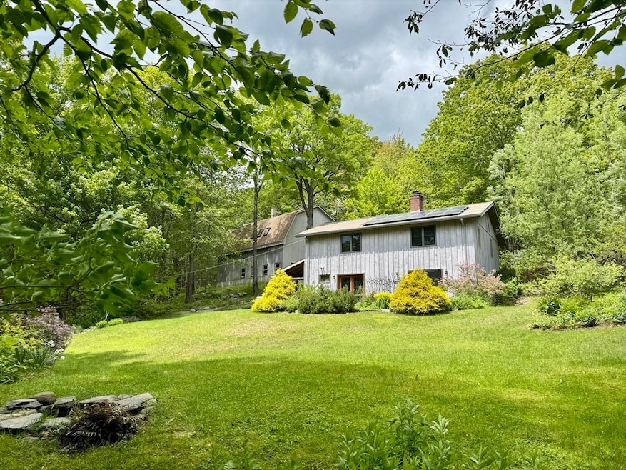

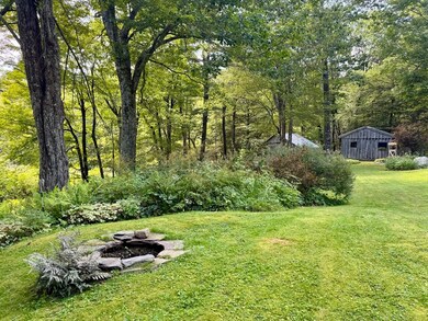
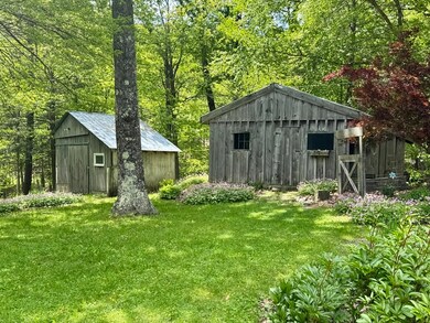


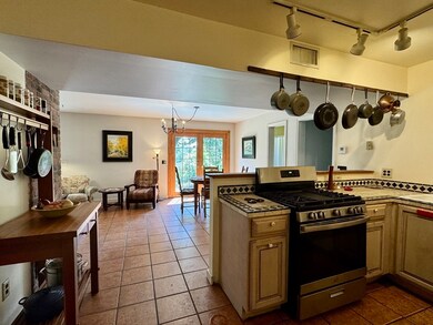
Nestled in a secluded and picturesque 2 acre setting, this charming home offers warmth, comfort and a place that truly feels like home. The property features an impressive 2-story 30' x 40' two-car garage with 14ft ceilings on the main level providing versatile space, ideal for a workshop, studio opportunity, or storage. Surrounded by natural landscape additional outdoor highlights include a small barn and chicken coop, perennial garden, fruit trees, stone walkway & outcroppings, inviting sitting areas and a fire pit. Inside, the lower level features an open-concept layout with a spacious kitchen, large dining and living area with built-ins, a wood stove, tile floors, a full bath, laundry area, and patio doors that fill the space with natural light. Upstairs, you’ll find three bedrooms and a full bath with a relaxing soaking tub. The location is perfect for nature lovers with plenty of outdoor recreation nearby. 30 minutes to Northampton & the Berkshires, 15 min to Shelburne Falls.
Last Agent to Sell the Property
Coldwell Banker Community REALTORS® Listed on: 08/26/2025
| Date | Type | Sale Price | Title Company |
|---|---|---|---|
| Deed | $457,000 | -- | |
| Quit Claim Deed | $355,000 | None Available | |
| Quit Claim Deed | -- | -- | |
| Deed | $120,000 | -- |
| Date | Status | Loan Amount | Loan Type |
|---|---|---|---|
| Open | $397,000 | New Conventional | |
| Previous Owner | $12,000 | No Value Available | |
| Previous Owner | $96,000 | Purchase Money Mortgage | |
| Previous Owner | $48,000 | No Value Available |
| Date | Event | Price | List to Sale | Price per Sq Ft |
|---|---|---|---|---|
| 10/10/2025 10/10/25 | Sold | $457,000 | +5.1% | $271 / Sq Ft |
| 08/29/2025 08/29/25 | Pending | -- | -- | -- |
| 08/26/2025 08/26/25 | For Sale | $435,000 | -- | $258 / Sq Ft |
| Year | Tax Paid | Tax Assessment Tax Assessment Total Assessment is a certain percentage of the fair market value that is determined by local assessors to be the total taxable value of land and additions on the property. | Land | Improvement |
|---|---|---|---|---|
| 2025 | $5,652 | $419,900 | $87,100 | $332,800 |
| 2024 | $5,622 | $384,800 | $87,100 | $297,700 |
| 2023 | $5,655 | $321,100 | $69,700 | $251,400 |
| 2022 | $4,654 | $267,800 | $66,200 | $201,600 |
| 2021 | $4,404 | $266,100 | $66,200 | $199,900 |
| 2020 | $4,433 | $266,100 | $66,200 | $199,900 |
| 2019 | $4,242 | $247,200 | $63,400 | $183,800 |
| 2018 | $4,247 | $247,200 | $63,400 | $183,800 |
| 2017 | $4,063 | $250,500 | $62,500 | $188,000 |
| 2016 | $3,937 | $239,500 | $62,500 | $177,000 |
| 2015 | $3,825 | $239,500 | $62,500 | $177,000 |
| 2014 | $3,982 | $246,400 | $58,700 | $187,700 |
Seller's Agent in 2025
Wanda Mooney
Coldwell Banker Community REALTORS®
(413) 768-9848
16 in this area
224 Total Sales
T
Buyer's Agent in 2025
Theodore Hanna
Cohn & Company
(413) 522-9937
3 in this area
80 Total Sales
Source: MLS Property Information Network (MLS PIN)
MLS Number: 73422392
APN: ASHF-000014-000000-000050
Disclaimer: Certain information contained herein is derived from information provided by parties other than Homes.com. All information provided is deemed reliable, but is not guaranteed to be accurate and should be independently verified.
![]() The property listing data and information, or the Images, set forth herein were provided to MLS Property Information Network, Inc. from third party sources, including sellers, lessors and public records, and were compiled by MLS Property Information Network, Inc. The property listing data and information, and the Images, are for the personal, non-commercial use of consumers having a good faith interest in purchasing or leasing listed properties of the type displayed to them and may not be used for any purpose other than to identify prospective properties which such consumers may have a good faith interest in purchasing or leasing. MLS Property Information Network, Inc. and its subscribers disclaim any and all representations and warranties as to the accuracy of the property listing data and information, or as to the accuracy of any of the Images, set forth herein.
The property listing data and information, or the Images, set forth herein were provided to MLS Property Information Network, Inc. from third party sources, including sellers, lessors and public records, and were compiled by MLS Property Information Network, Inc. The property listing data and information, and the Images, are for the personal, non-commercial use of consumers having a good faith interest in purchasing or leasing listed properties of the type displayed to them and may not be used for any purpose other than to identify prospective properties which such consumers may have a good faith interest in purchasing or leasing. MLS Property Information Network, Inc. and its subscribers disclaim any and all representations and warranties as to the accuracy of the property listing data and information, or as to the accuracy of any of the Images, set forth herein.