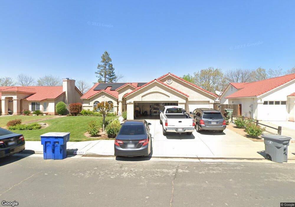
1453 Oak Ave Clovis, CA 93611
Estimated Value: $460,000 - $496,000
3
Beds
2
Baths
1,800
Sq Ft
$264/Sq Ft
Est. Value
About This Home
This home is located at 1453 Oak Ave, Clovis, CA 93611 and is currently estimated at $476,056, approximately $264 per square foot. 1453 Oak Ave is a home located in Fresno County with nearby schools including Century Elementary School, Alta Sierra Intermediate School, and Buchanan High School.
Ownership History
Date
Name
Owned For
Owner Type
Purchase Details
Closed on
Oct 19, 2023
Sold by
Pedersen William R and Pedersen Maria F
Bought by
Pedersen Family Living Trust and Pedersen
Current Estimated Value
Purchase Details
Closed on
Mar 3, 2021
Sold by
Pedersen William R and Pedersen Maria F
Bought by
Pedersen William R and Pedersen Maria F
Home Financials for this Owner
Home Financials are based on the most recent Mortgage that was taken out on this home.
Original Mortgage
$134,750
Interest Rate
2.7%
Mortgage Type
New Conventional
Create a Home Valuation Report for This Property
The Home Valuation Report is an in-depth analysis detailing your home's value as well as a comparison with similar homes in the area
Home Values in the Area
Average Home Value in this Area
Purchase History
| Date | Buyer | Sale Price | Title Company |
|---|---|---|---|
| Pedersen Family Living Trust | -- | None Listed On Document | |
| Pedersen William R | -- | Chicago Title Company |
Source: Public Records
Mortgage History
| Date | Status | Borrower | Loan Amount |
|---|---|---|---|
| Previous Owner | Pedersen William R | $134,750 |
Source: Public Records
Tax History
| Year | Tax Paid | Tax Assessment Tax Assessment Total Assessment is a certain percentage of the fair market value that is determined by local assessors to be the total taxable value of land and additions on the property. | Land | Improvement |
|---|---|---|---|---|
| 2025 | $937 | $238,611 | $76,473 | $162,138 |
| 2023 | $2,875 | $229,347 | $73,504 | $155,843 |
| 2022 | $2,839 | $224,851 | $72,063 | $152,788 |
| 2021 | $2,743 | $220,443 | $70,650 | $149,793 |
| 2020 | $2,733 | $218,184 | $69,926 | $148,258 |
| 2019 | $2,683 | $213,906 | $68,555 | $145,351 |
| 2018 | $2,627 | $209,712 | $67,211 | $142,501 |
| 2017 | $2,585 | $205,601 | $65,894 | $139,707 |
| 2016 | $2,502 | $201,570 | $64,602 | $136,968 |
| 2015 | $2,453 | $198,543 | $63,632 | $134,911 |
| 2014 | $2,410 | $194,655 | $62,386 | $132,269 |
Source: Public Records
Map
Nearby Homes
- 1323 Oak Ave
- 1124 Oak Ave
- 1754 Decatur Ave
- 1490 Fir Ave
- 1303 Jordan Ave
- 878 N Ash Ave
- 1977 Goshen Ave
- 2117 Goshen Ave
- 8220 N Fowler Ave
- 971 N Filbert Ave
- 367 N Raphael Ln Unit 367
- 166 Bedford Ave
- 2361 Cromwell Ave
- 22 N Bliss Ave
- 338 N Filbert Ave
- 2051 Los Altos Ave
- 2047 Menlo Ave
- 2051 Sierra Ave
- 1498 Escalon Ave
- 1855 Vartikian Ave
- 1463 Oak Ave
- 1447 Oak Ave
- 1473 Oak Ave
- 1443 Oak Ave
- 1452 Oak Ave
- 777 N Miami Ave
- 1466 Oak Ave
- 0 Alluvial Ave
- 1483 Oak Ave
- 1472 Oak Ave
- 767 N Miami Ave
- 1435 Oak Ave
- 1480 Oak Ave
- 782 N Miami Ave
- 1485 Oak Ave
- 1491 Alluvial Ave
- 1491 Alluvial Ave Unit 1491 Alluvial Ave 40
- 1491 Alluvial Ave Unit 1491 Alluvial Ave 30
- 1491 Alluvial Ave
- 1465 Minarets Ave
Your Personal Tour Guide
Ask me questions while you tour the home.