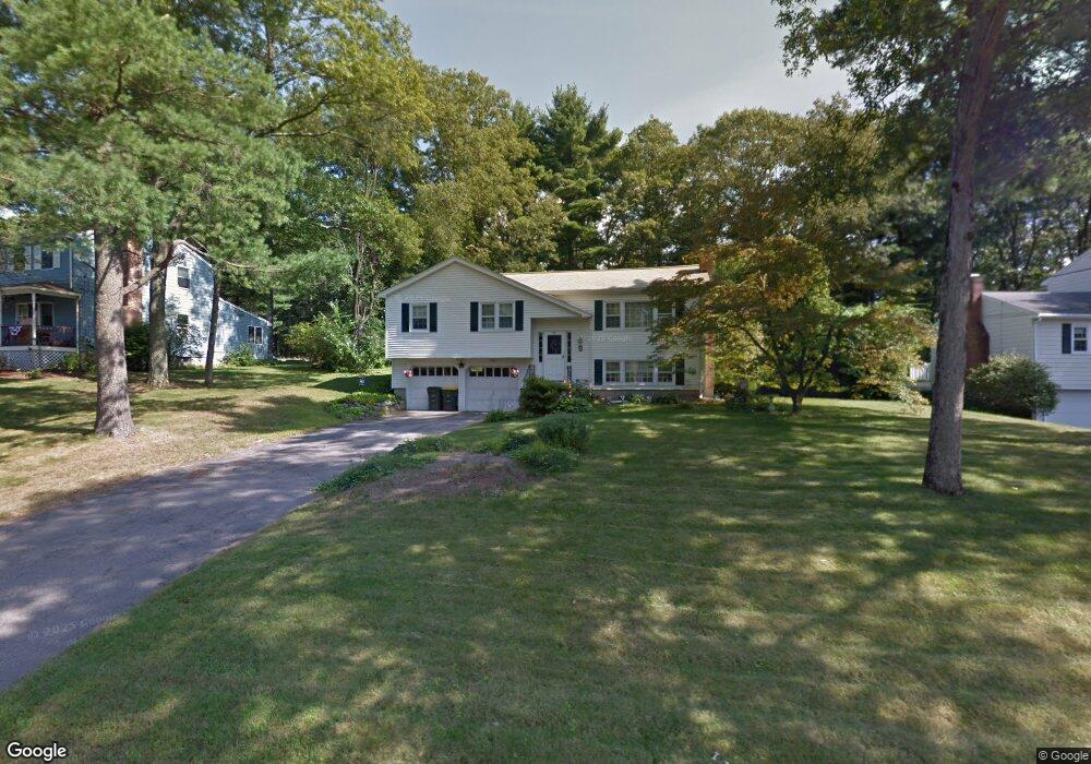
147 Longhill Rd Franklin, MA 02038
Estimated Value: $505,617 - $620,000
3
Beds
2
Baths
1,034
Sq Ft
$545/Sq Ft
Est. Value
About This Home
This home is located at 147 Longhill Rd, Franklin, MA 02038 and is currently estimated at $563,654, approximately $545 per square foot. 147 Longhill Rd is a home located in Norfolk County with nearby schools including Oak Street Elementary School, Horace Mann Middle School, and Franklin High School.
Ownership History
Date
Name
Owned For
Owner Type
Purchase Details
Closed on
Nov 26, 1991
Sold by
Demuro Gerard J and Demuro Kathy A
Bought by
Gill Jean M
Current Estimated Value
Home Financials for this Owner
Home Financials are based on the most recent Mortgage that was taken out on this home.
Original Mortgage
$100,000
Interest Rate
8.7%
Mortgage Type
Purchase Money Mortgage
Create a Home Valuation Report for This Property
The Home Valuation Report is an in-depth analysis detailing your home's value as well as a comparison with similar homes in the area
Purchase History
| Date | Buyer | Sale Price | Title Company |
|---|---|---|---|
| Gill Jean M | $135,000 | -- |
Source: Public Records
Mortgage History
| Date | Status | Borrower | Loan Amount |
|---|---|---|---|
| Closed | Gill Jean M | $100,000 |
Source: Public Records
Tax History
| Year | Tax Paid | Tax Assessment Tax Assessment Total Assessment is a certain percentage of the fair market value that is determined by local assessors to be the total taxable value of land and additions on the property. | Land | Improvement |
|---|---|---|---|---|
| 2025 | $6,263 | $539,000 | $326,300 | $212,700 |
| 2024 | $6,127 | $519,700 | $326,300 | $193,400 |
| 2023 | $5,998 | $476,800 | $283,400 | $193,400 |
| 2022 | $5,416 | $385,500 | $214,700 | $170,800 |
| 2021 | $5,419 | $369,900 | $238,600 | $131,300 |
| 2020 | $5,045 | $347,700 | $222,800 | $124,900 |
| 2019 | $4,981 | $339,800 | $214,900 | $124,900 |
| 2018 | $4,735 | $323,200 | $211,000 | $112,200 |
| 2017 | $4,511 | $309,400 | $197,200 | $112,200 |
| 2016 | $4,296 | $296,300 | $199,900 | $96,400 |
| 2015 | $4,321 | $291,200 | $194,800 | $96,400 |
| 2014 | $3,862 | $267,300 | $170,900 | $96,400 |
Source: Public Records
Map
Nearby Homes
- 204 Lincoln St
- 17 Longhill Rd
- 30 Longobardi Dr Unit 30
- 100 Daniels St
- 6 Lydia Ln
- 14 Pleasant St Unit B
- 14 Waites Crossing
- 6 Pine Knoll Rd
- 10 Waites Crossing
- 70 Oak St
- 9 Elliot Mills Unit 5
- 8 Elliot Mills Unit 30
- 5 Elliot Mills Unit 3
- 7 Elliot Mills Unit 4
- 10 Elliot Mills Unit 29
- 88 Crescent St
- 41 Kimberlee Ave
- 3 Oak View Terrace Unit 3
- 75 Jordan Rd
- 19 Waites Crossing
- 149 Longhill Rd
- 145 Longhill Rd
- 151 Longhill Rd
- 146 Longhill Rd
- 492 Old Farm Rd
- 94 Pheasant Hill Rd
- 486 Old Farm Rd
- 1 Meadowbrook Rd
- 148 Longhill Rd
- 84 Pheasant Hill Rd
- 498 Old Farm Rd
- 153 Longhill Rd
- 150 Longhill Rd
- 3 Meadowbrook Rd
- 74 Pheasant Hill Rd
- 152 Longhill Rd
- 516 Old Farm Rd
- 3 Eagle Dr
- 1 Eagle Dr
- 142 Longhill Rd
Your Personal Tour Guide
Ask me questions while you tour the home.