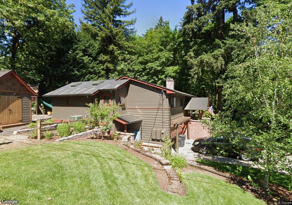
1497 Burns St Unit D West Linn, OR 97068
Bolton NeighborhoodEstimated Value: $642,000 - $898,000
3
Beds
3
Baths
2,174
Sq Ft
$330/Sq Ft
Est. Value
About This Home
This home is located at 1497 Burns St Unit D, West Linn, OR 97068 and is currently estimated at $717,751, approximately $330 per square foot. 1497 Burns St Unit D is a home located in Clackamas County with nearby schools including Bolton Primary School, West Linn High School, and Clackamas Academy of Industrial Sciences (CAIS).
Ownership History
Date
Name
Owned For
Owner Type
Purchase Details
Closed on
Oct 16, 2023
Sold by
Borntrager Tawnya E
Bought by
Borntrager Tawnya E and Borntrager Bryon
Current Estimated Value
Purchase Details
Closed on
Jul 23, 2003
Sold by
Borntrager Bryon
Bought by
Borntrager Tawnya E
Home Financials for this Owner
Home Financials are based on the most recent Mortgage that was taken out on this home.
Original Mortgage
$171,500
Interest Rate
5.15%
Mortgage Type
Purchase Money Mortgage
Purchase Details
Closed on
May 13, 2002
Sold by
Robert Smith & Associates Ltd
Bought by
Borntrager Bryon
Home Financials for this Owner
Home Financials are based on the most recent Mortgage that was taken out on this home.
Original Mortgage
$168,150
Interest Rate
7.13%
Create a Home Valuation Report for This Property
The Home Valuation Report is an in-depth analysis detailing your home's value as well as a comparison with similar homes in the area
Home Values in the Area
Average Home Value in this Area
Purchase History
| Date | Buyer | Sale Price | Title Company |
|---|---|---|---|
| Borntrager Tawnya E | -- | None Listed On Document | |
| Borntrager Tawnya E | -- | Chicago Title Insurance Comp | |
| Borntrager Bryon | $177,000 | Chicago Title Insurance Comp |
Source: Public Records
Mortgage History
| Date | Status | Borrower | Loan Amount |
|---|---|---|---|
| Previous Owner | Borntrager Tawnya E | $171,500 | |
| Previous Owner | Borntrager Bryon | $168,150 |
Source: Public Records
Tax History
| Year | Tax Paid | Tax Assessment Tax Assessment Total Assessment is a certain percentage of the fair market value that is determined by local assessors to be the total taxable value of land and additions on the property. | Land | Improvement |
|---|---|---|---|---|
| 2025 | $7,302 | $378,919 | -- | -- |
| 2024 | $7,029 | $367,883 | -- | -- |
| 2023 | $7,029 | $341,050 | $0 | $0 |
| 2022 | $5,905 | $308,659 | $0 | $0 |
| 2021 | $5,606 | $299,669 | $0 | $0 |
| 2020 | $5,644 | $290,941 | $0 | $0 |
| 2019 | $5,382 | $282,467 | $0 | $0 |
| 2018 | $5,142 | $274,240 | $0 | $0 |
| 2017 | $4,917 | $266,252 | $0 | $0 |
| 2016 | $4,686 | $258,497 | $0 | $0 |
Source: Public Records
Map
Nearby Homes
- 1471 Burns St
- 1310 Heater Ct
- 5645 W A St
- 5557 River St
- 5767 Terrace Dr
- 2145 Webb St
- 5910 W A St
- 5980 W A St
- 6002 Skyline Cir
- 1895 Buck St
- 5089 Territorial Dr
- 1701 Clackamette Dr Unit 2
- 6141 Skyline Dr
- 6123 Skyline Dr
- 6352 Caufield St
- 19605 River Rd Unit 104
- 2010 Maple Terrace
- 4711 Alder St
- 2334 Randall St
- 22790 Oregon City Loop
Your Personal Tour Guide
Ask me questions while you tour the home.