Estimated Value: $1,205,000 - $1,497,443
4
Beds
2
Baths
1,242
Sq Ft
$1,085/Sq Ft
Est. Value
About This Home
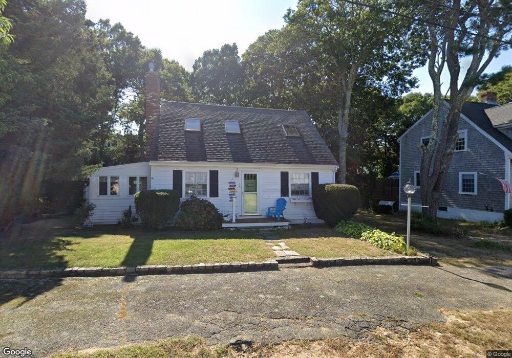
This home is located at 15 Pine Ave, Mashpee, MA 02649 and is currently estimated at $1,348,111, approximately $1,085 per square foot. 15 Pine Ave is a home located in Barnstable County with nearby schools including Kenneth C. Coombs School, Quashnet School, and Mashpee Middle School.
Ownership History
Date
Name
Owned For
Owner Type
Purchase Details
Closed on
Aug 22, 2024
Sold by
Vargas Jody
Bought by
Jody Vargas T and Jody Vargas
Current Estimated Value
Purchase Details
Closed on
Dec 12, 2023
Sold by
Bubencik Robert J and Bubencik Pauline C
Bought by
Pauline C Bubencik Ret and Bubenicik
Purchase Details
Closed on
Jun 15, 1994
Sold by
Arnold Berger T and Arnold Couture
Bought by
Bubencik Robt J and Bubencik Pauline C
Home Financials for this Owner
Home Financials are based on the most recent Mortgage that was taken out on this home.
Original Mortgage
$108,000
Interest Rate
8.5%
Mortgage Type
Purchase Money Mortgage
Create a Home Valuation Report for This Property
The Home Valuation Report is an in-depth analysis detailing your home's value as well as a comparison with similar homes in the area
Home Values in the Area
Average Home Value in this Area
Purchase History
| Date | Buyer | Sale Price | Title Company |
|---|---|---|---|
| Jody Vargas T | -- | None Available | |
| Pauline C Bubencik Ret | -- | None Available | |
| Bubencik Robt J | $135,000 | -- | |
| Bubencik Robt J | $135,000 | -- |
Source: Public Records
Mortgage History
| Date | Status | Borrower | Loan Amount |
|---|---|---|---|
| Previous Owner | Bubencik Robt J | $108,000 |
Source: Public Records
Tax History
| Year | Tax Paid | Tax Assessment Tax Assessment Total Assessment is a certain percentage of the fair market value that is determined by local assessors to be the total taxable value of land and additions on the property. | Land | Improvement |
|---|---|---|---|---|
| 2025 | $9,549 | $1,442,400 | $1,165,300 | $277,100 |
| 2024 | $8,535 | $1,327,300 | $1,059,600 | $267,700 |
| 2023 | $7,506 | $1,070,700 | $853,700 | $217,000 |
| 2022 | $7,082 | $866,800 | $694,100 | $172,700 |
| 2021 | $5,217 | $776,500 | $625,200 | $151,300 |
| 2020 | $6,790 | $747,000 | $601,300 | $145,700 |
| 2019 | $6,682 | $738,300 | $601,300 | $137,000 |
| 2018 | $4,775 | $698,700 | $574,000 | $124,700 |
| 2017 | $6,503 | $707,600 | $595,800 | $111,800 |
| 2016 | $6,478 | $701,100 | $595,800 | $105,300 |
Source: Public Records
Map
Nearby Homes
- 3 Hyannis Point Rd Unit 790
- 3 Hyannis Point Rd
- 6 Hammock Pond Rd
- 6 Hammock Pond Rd Unit 6
- 15 Brant Rock Rd Unit 765
- 33 Landmark Ave
- 21 Milestone Way Unit 620
- 251 Shore Dr Unit D2
- 251 Shore Dr Unit D2
- 101 Greensward Rd
- 11 Milestone Way Unit 624
- 25 Milestone Way Unit 25
- 25 Milestone Way
- 46 Greensward Cir
- 128 Uncle Percys Rd
- 37 The Hunt Cir
- 42 Kim Path
- 16 Slice Way
- 7 Blue Fin
- 42 Fells Pond Rd
- 17 Pine Ave
- 11 Pine Ave
- 19 Pine Ave
- 19 Pine Ave Unit 17
- 20 Pine Ave
- 23 Pine Ave
- 12 Rock Island Rd
- 12 Rock Landing Rd
- 10 Rock Island Rd
- 16 Pine Ave
- 14 Pine Ave
- 8 Rock Landing Rd
- 7 Pine Ave
- 7 Pine Ave Unit 4
- 8 Rock Island Rd
- 14 Rock Island Rd
- 14 Rock Landing Rd
- 12 Pine Ave
- 22 Pine Ave
- 22 Pine Ave Unit 29
Your Personal Tour Guide
Ask me questions while you tour the home.