Estimated Value: $308,000 - $343,000
3
Beds
3
Baths
2,265
Sq Ft
$144/Sq Ft
Est. Value
About This Home
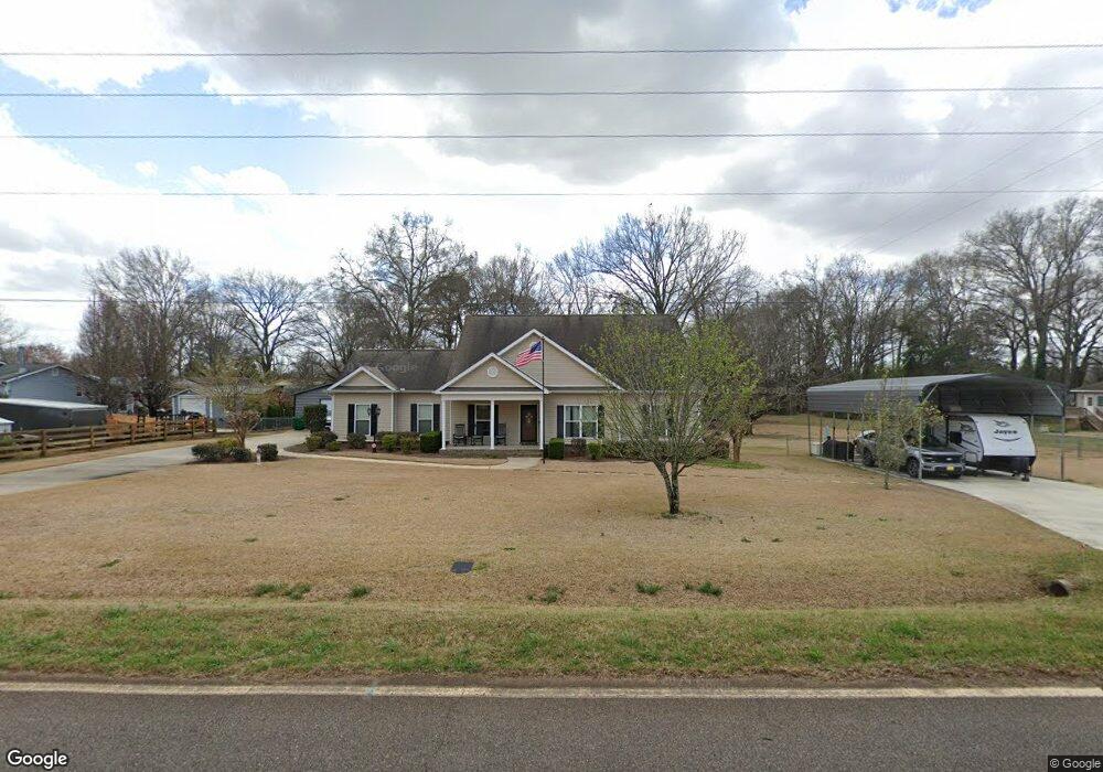
This home is located at 150 Todd Rd, Perry, GA 31069 and is currently estimated at $326,899, approximately $144 per square foot. 150 Todd Rd is a home with nearby schools including Langston Road Elementary School, Mossy Creek Middle School, and Perry High School.
Ownership History
Date
Name
Owned For
Owner Type
Purchase Details
Closed on
Jan 13, 2011
Sold by
Sessions Kenneth and Sessions Marilyn
Bought by
Odom Scott L and Odom Joyce S
Current Estimated Value
Purchase Details
Closed on
Nov 4, 2005
Sold by
Bedrick Ivis F
Bought by
Sessions Kenneth and Sessions Marilyn
Purchase Details
Closed on
Apr 4, 2001
Sold by
Phillips Harry K Jr Estate
Bought by
Phillips Deette A
Purchase Details
Closed on
Nov 20, 1991
Sold by
Phillips Deetta
Bought by
Phillips Harry K
Purchase Details
Closed on
Aug 7, 1991
Sold by
Bedrick John
Bought by
Phillips Harry K and Phillips Deetta
Purchase Details
Closed on
Nov 22, 1985
Sold by
Jackson Calvin P
Bought by
Bedrick John
Purchase Details
Closed on
Jun 10, 1982
Sold by
White Richard H
Bought by
Jackson Calvin P
Purchase Details
Closed on
Jan 9, 1980
Sold by
White Richard E and White Richard H
Bought by
White Richard H
Create a Home Valuation Report for This Property
The Home Valuation Report is an in-depth analysis detailing your home's value as well as a comparison with similar homes in the area
Home Values in the Area
Average Home Value in this Area
Purchase History
| Date | Buyer | Sale Price | Title Company |
|---|---|---|---|
| Odom Scott L | $25,000 | None Available | |
| Sessions Kenneth | $17,500 | -- | |
| Phillips Deette A | -- | -- | |
| Phillips Harry K | -- | -- | |
| Phillips Harry K | -- | -- | |
| Bedrick John | -- | -- | |
| Bedrick John | -- | -- | |
| Jackson Calvin P | -- | -- | |
| White Richard H | -- | -- |
Source: Public Records
Tax History
| Year | Tax Paid | Tax Assessment Tax Assessment Total Assessment is a certain percentage of the fair market value that is determined by local assessors to be the total taxable value of land and additions on the property. | Land | Improvement |
|---|---|---|---|---|
| 2025 | $2,152 | $102,280 | $12,600 | $89,680 |
| 2024 | $2,307 | $98,440 | $12,600 | $85,840 |
| 2023 | $1,958 | $83,000 | $12,600 | $70,400 |
| 2022 | $1,792 | $76,160 | $12,600 | $63,560 |
| 2021 | $1,542 | $65,480 | $6,000 | $59,480 |
| 2020 | $1,435 | $60,800 | $5,680 | $55,120 |
| 2019 | $1,435 | $60,800 | $5,680 | $55,120 |
| 2018 | $1,435 | $60,800 | $5,680 | $55,120 |
| 2017 | $1,437 | $60,800 | $5,680 | $55,120 |
| 2016 | $1,439 | $60,800 | $5,680 | $55,120 |
| 2015 | $1,442 | $60,800 | $5,680 | $55,120 |
| 2014 | -- | $60,800 | $5,680 | $55,120 |
| 2013 | -- | $60,800 | $5,680 | $55,120 |
Source: Public Records
Map
Nearby Homes
- 309 Bermuda Ridge
- 108 Chimney Rock Rd
- 105 Senimor Ct
- 501 Longhorn Trail
- 204 Greylock Dr
- 124 Lake Lillian Dr
- 103 Denali Dr
- 502 Arons Ct
- 150 MacK Thompson Rd
- 0 MacK Thompson Rd Unit 253661
- 149 MacK Thompson Road Common
- 127 Bramblewood Ln
- 117 Bramblewood Ln
- 119 Bramblewood Ln
- 115 Bramblewood Ln
- 0 Hwy 41 & Langston Rd Unit M170042
- 0 Langston Rd Unit 16828609
- 111 Breakwater Way
- 118 Bramblewood Way
- 2327 Us Hwy 41
Your Personal Tour Guide
Ask me questions while you tour the home.