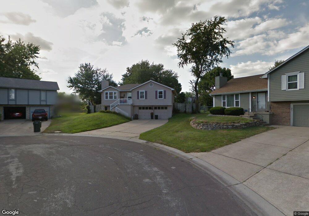
1504 NE Westwind Dr Lees Summit, MO 64086
Estimated Value: $264,389 - $307,000
3
Beds
2
Baths
1,098
Sq Ft
$266/Sq Ft
Est. Value
About This Home
This home is located at 1504 NE Westwind Dr, Lees Summit, MO 64086 and is currently estimated at $291,847, approximately $265 per square foot. 1504 NE Westwind Dr is a home located in Jackson County with nearby schools including Underwood Elementary School, Bernard C. Campbell Middle School, and Lee's Summit North High School.
Ownership History
Date
Name
Owned For
Owner Type
Purchase Details
Closed on
May 31, 2001
Sold by
Hogan John M and Hogan Sara B
Bought by
Richardson Gina M
Current Estimated Value
Home Financials for this Owner
Home Financials are based on the most recent Mortgage that was taken out on this home.
Original Mortgage
$83,000
Outstanding Balance
$30,136
Interest Rate
6.5%
Mortgage Type
Purchase Money Mortgage
Estimated Equity
$261,711
Create a Home Valuation Report for This Property
The Home Valuation Report is an in-depth analysis detailing your home's value as well as a comparison with similar homes in the area
Home Values in the Area
Average Home Value in this Area
Purchase History
| Date | Buyer | Sale Price | Title Company |
|---|---|---|---|
| Richardson Gina M | -- | Chicago Title Co |
Source: Public Records
Mortgage History
| Date | Status | Borrower | Loan Amount |
|---|---|---|---|
| Open | Richardson Gina M | $83,000 |
Source: Public Records
Tax History
| Year | Tax Paid | Tax Assessment Tax Assessment Total Assessment is a certain percentage of the fair market value that is determined by local assessors to be the total taxable value of land and additions on the property. | Land | Improvement |
|---|---|---|---|---|
| 2025 | $2,716 | $35,680 | $7,089 | $28,591 |
| 2024 | $2,697 | $37,620 | $29,460 | $8,160 |
| 2023 | $2,697 | $37,621 | $8,161 | $29,460 |
| 2022 | $2,178 | $26,980 | $3,631 | $23,349 |
| 2021 | $2,223 | $26,980 | $3,631 | $23,349 |
| 2020 | $2,134 | $26,602 | $3,631 | $22,971 |
| 2019 | $2,153 | $26,602 | $3,631 | $22,971 |
| 2018 | $2,019 | $23,152 | $3,160 | $19,992 |
| 2017 | $2,019 | $23,152 | $3,160 | $19,992 |
| 2016 | $1,989 | $22,572 | $3,249 | $19,323 |
Source: Public Records
Map
Nearby Homes
- 1133 NE Mulberry St
- 1141 NE Hunters Ridge
- 812 NE Mulberry St
- 1541 NE Neawanna Dr
- 809 NE Cedar St
- 1118 NE Deerbrook Terrace
- 816 NE Pollard St
- 1708 NE Balboa St
- 718 NE Mulberry St
- 1213 NE Ball Dr
- 717 NE Mulberry St
- 1300 NE Browning Ln
- 1104 NE Country Ln
- 1625 NE Thames Dr
- 401 NE Mulberry St
- 400 NE Mulberry St
- .342 acres NE Victoria Dr
- 1108 NE Woodbury Ct
- 905 NE Country Ln
- 1217 NE Magnolia St
- 1500 NE Westwind Dr
- 1508 NE Westwind Dr
- 1512 NE Westwind Dr
- 1505 NE Westwind Dr
- 1005 NE Chestnut St
- 1613 NE Ridgeview Dr
- 1007 NE Chestnut St
- 1509 NE Westwind Dr
- 1615 NE Ridgeview Dr
- 1003 NE Chestnut St
- 1611 NE Ridgeview Dr
- 1516 NE Westwind Dr
- 1009 NE Chestnut St
- 1001 NE Chestnut St
- 1609 NE Ridgeview Dr
- 1513 NE Westwind Dr
- 1011 NE Chestnut St
- 1014 NE Mulberry St
- 1520 NE Westwind Dr
- 1010 NE Mulberry St
Your Personal Tour Guide
Ask me questions while you tour the home.