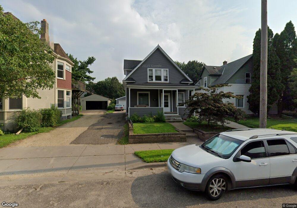
1508 Selby Ave Saint Paul, MN 55104
Union Park NeighborhoodEstimated Value: $240,000 - $291,000
3
Beds
1
Bath
1,272
Sq Ft
$216/Sq Ft
Est. Value
About This Home
This home is located at 1508 Selby Ave, Saint Paul, MN 55104 and is currently estimated at $274,788, approximately $216 per square foot. 1508 Selby Ave is a home located in Ramsey County with nearby schools including Maxfield Magnet Elementary School, Hidden River Middle School, and Central Senior High School.
Ownership History
Date
Name
Owned For
Owner Type
Purchase Details
Closed on
Nov 18, 2022
Sold by
Hupp Alan W and Hupp Karen M
Bought by
Karen M Hupp Revocable Trust
Current Estimated Value
Purchase Details
Closed on
Nov 2, 2018
Sold by
Boucher Michael J
Bought by
Hupp Alan W
Home Financials for this Owner
Home Financials are based on the most recent Mortgage that was taken out on this home.
Original Mortgage
$184,000
Interest Rate
4.6%
Mortgage Type
Future Advance Clause Open End Mortgage
Purchase Details
Closed on
Nov 7, 1996
Sold by
Brennan Andrew R
Bought by
Boucher Michael J
Create a Home Valuation Report for This Property
The Home Valuation Report is an in-depth analysis detailing your home's value as well as a comparison with similar homes in the area
Home Values in the Area
Average Home Value in this Area
Purchase History
| Date | Buyer | Sale Price | Title Company |
|---|---|---|---|
| Karen M Hupp Revocable Trust | $3,000 | -- | |
| Hupp Alan W | $200,000 | Partners Title Llc | |
| Boucher Michael J | $68,000 | -- |
Source: Public Records
Mortgage History
| Date | Status | Borrower | Loan Amount |
|---|---|---|---|
| Previous Owner | Hupp Alan W | $184,000 |
Source: Public Records
Tax History Compared to Growth
Tax History
| Year | Tax Paid | Tax Assessment Tax Assessment Total Assessment is a certain percentage of the fair market value that is determined by local assessors to be the total taxable value of land and additions on the property. | Land | Improvement |
|---|---|---|---|---|
| 2025 | $3,924 | $255,500 | $53,800 | $201,700 |
| 2023 | $3,924 | $241,700 | $53,800 | $187,900 |
| 2022 | $3,612 | $253,600 | $53,800 | $199,800 |
| 2021 | $3,278 | $220,600 | $53,800 | $166,800 |
| 2020 | $3,554 | $207,300 | $53,800 | $153,500 |
| 2019 | $2,814 | $209,100 | $53,800 | $155,300 |
| 2018 | $2,814 | $180,900 | $53,800 | $127,100 |
| 2017 | $2,714 | $178,600 | $53,800 | $124,800 |
| 2016 | $2,534 | $0 | $0 | $0 |
| 2015 | $2,542 | $156,500 | $45,700 | $110,800 |
| 2014 | $2,086 | $0 | $0 | $0 |
Source: Public Records
Map
Nearby Homes
- 1510 Laurel Ave
- 184 Saratoga St N
- 1447 Hague Ave
- 1540 Ashland Ave Unit 12
- 750 Summit Ave
- 266 Fry St
- 1670 Ashland Ave
- 1611 Carroll Ave
- 1671 Marshall Ave
- 1325 Dayton Ave
- 1319 Dayton Ave
- 12XX Marshall Ave
- 1354 Grand Ave
- 1259 Hague Ave
- 1253 Ashland Ave
- 1247 Selby Ave
- 382 Fry St
- 389 Roy St N
- 193 Griggs St N
- 1798 Marshall Ave