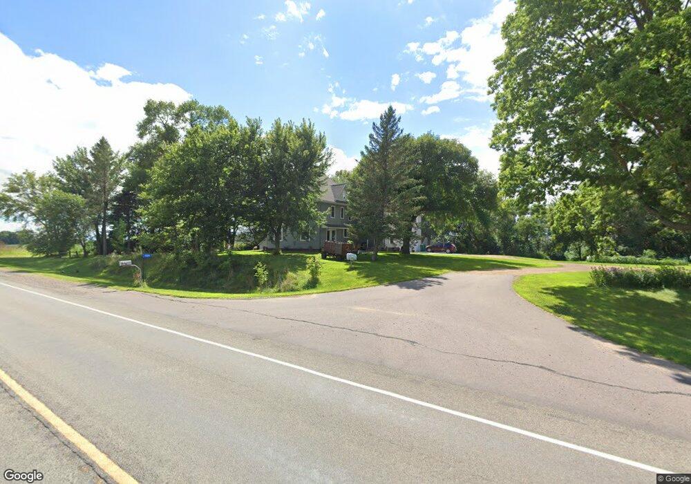
15104 State Highway 22 Good Thunder, MN 56037
Estimated Value: $330,000 - $469,000
5
Beds
4
Baths
3,616
Sq Ft
$111/Sq Ft
Est. Value
About This Home
This home is located at 15104 State Highway 22, Good Thunder, MN 56037 and is currently estimated at $401,030, approximately $110 per square foot. 15104 State Highway 22 is a home located in Blue Earth County with nearby schools including Maple River Secondary School.
Ownership History
Date
Name
Owned For
Owner Type
Purchase Details
Closed on
Jul 15, 2020
Sold by
Fredrick Edward A J and Fredrick Teri L
Bought by
Schneider Trust
Current Estimated Value
Purchase Details
Closed on
Jul 14, 2020
Sold by
Wyn Heidi and Pautsch Joalle M
Bought by
Beske Brock W and Fredrick Teri L
Purchase Details
Closed on
Nov 6, 2015
Sold by
Beske Brock W
Bought by
Fredrick Edward A J and Fredrick Teri L
Create a Home Valuation Report for This Property
The Home Valuation Report is an in-depth analysis detailing your home's value as well as a comparison with similar homes in the area
Home Values in the Area
Average Home Value in this Area
Purchase History
| Date | Buyer | Sale Price | Title Company |
|---|---|---|---|
| Schneider Trust | $219,000 | None Available | |
| Beske Brock W | -- | Mn River Valley Title | |
| Fredrick Edward A J | $202,000 | Minnesota River Valley Title |
Source: Public Records
Tax History Compared to Growth
Tax History
| Year | Tax Paid | Tax Assessment Tax Assessment Total Assessment is a certain percentage of the fair market value that is determined by local assessors to be the total taxable value of land and additions on the property. | Land | Improvement |
|---|---|---|---|---|
| 2025 | $2,914 | $394,700 | $69,700 | $325,000 |
| 2024 | $2,914 | $363,600 | $69,700 | $293,900 |
| 2023 | $2,424 | $306,500 | $69,700 | $236,800 |
| 2022 | $2,286 | $272,700 | $69,700 | $203,000 |
| 2021 | $2,644 | $229,600 | $69,700 | $159,900 |
| 2020 | $1,854 | $256,200 | $58,100 | $198,100 |
| 2019 | $1,834 | $256,200 | $58,100 | $198,100 |
| 2018 | $1,580 | $245,300 | $58,100 | $187,200 |
| 2017 | $1,590 | $217,100 | $58,100 | $159,000 |
| 2016 | $1,488 | $211,100 | $58,100 | $153,000 |
| 2015 | $14 | $198,600 | $58,100 | $140,500 |
| 2014 | $1,720 | $199,300 | $58,100 | $141,200 |
Source: Public Records
Map
Nearby Homes
- 0 Tbd E Tbd Unit 7038384
- 0 Tbd E 161st St
- 15124 594th Ave
- 16225 563rd Ave
- 503 Central Ave N
- 507 507 Ne 6th Ave
- 17172 17172 State 22 Hwy Unit 17172 State Highway
- 202 Silver St E
- 202 202 E Silver St
- 103 Calm Ct SW
- 303 303 Se Grove St
- 303 Grove St SE
- 305 305 Se 3rd Ave
- 208 Lincoln St SW
- 503 Central Ave S
- 507 3rd Ave SW
- 55997 132nd St
- 211 211 S Houk St
- 57868 179th St
- 13698 Maple Rd