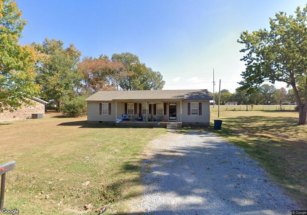
1518 Michael St Covington, TN 38019
Estimated Value: $150,000 - $198,767
Studio
2
Baths
1,248
Sq Ft
$140/Sq Ft
Est. Value
About This Home
This home is located at 1518 Michael St, Covington, TN 38019 and is currently estimated at $174,942, approximately $140 per square foot. 1518 Michael St is a home located in Tipton County with nearby schools including Crestview Elementary School, Crestview Middle School, and Covington High School.
Ownership History
Date
Name
Owned For
Owner Type
Purchase Details
Closed on
Jan 11, 2006
Sold by
Paul Stout
Bought by
Levert Robinson
Current Estimated Value
Home Financials for this Owner
Home Financials are based on the most recent Mortgage that was taken out on this home.
Original Mortgage
$92,150
Outstanding Balance
$50,410
Interest Rate
6.21%
Estimated Equity
$124,532
Purchase Details
Closed on
Mar 6, 2003
Sold by
Judy Erwin
Bought by
Paul Stout
Home Financials for this Owner
Home Financials are based on the most recent Mortgage that was taken out on this home.
Original Mortgage
$62,400
Interest Rate
5.88%
Purchase Details
Closed on
Feb 28, 2003
Bought by
Stout Paul and Stout Valerie M
Home Financials for this Owner
Home Financials are based on the most recent Mortgage that was taken out on this home.
Original Mortgage
$62,400
Interest Rate
5.88%
Purchase Details
Closed on
May 21, 1984
Bought by
Kitchens Leroy and Minnie Louise
Purchase Details
Closed on
May 23, 1975
Purchase Details
Closed on
Jan 7, 1966
Create a Home Valuation Report for This Property
The Home Valuation Report is an in-depth analysis detailing your home's value as well as a comparison with similar homes in the area
Purchase History
| Date | Buyer | Sale Price | Title Company |
|---|---|---|---|
| Levert Robinson | $87,000 | -- | |
| Paul Stout | $6,500 | -- | |
| Stout Paul | $6,500 | -- | |
| Kitchens Leroy | -- | -- | |
| -- | -- | -- | |
| -- | -- | -- |
Source: Public Records
Mortgage History
| Date | Status | Borrower | Loan Amount |
|---|---|---|---|
| Open | Not Available | $92,150 | |
| Previous Owner | Not Available | $62,400 |
Source: Public Records
Tax History
| Year | Tax Paid | Tax Assessment Tax Assessment Total Assessment is a certain percentage of the fair market value that is determined by local assessors to be the total taxable value of land and additions on the property. | Land | Improvement |
|---|---|---|---|---|
| 2025 | -- | $34,100 | $4,875 | $29,225 |
| 2024 | $0 | $34,100 | $4,875 | $29,225 |
| 2023 | $864 | $34,100 | $4,875 | $29,225 |
| 2022 | $783 | $23,875 | $3,575 | $20,300 |
| 2021 | $783 | $23,875 | $3,575 | $20,300 |
| 2020 | $783 | $23,875 | $3,575 | $20,300 |
| 2019 | $852 | $22,725 | $2,750 | $19,975 |
| 2018 | $852 | $22,725 | $2,750 | $19,975 |
| 2017 | $852 | $22,725 | $2,750 | $19,975 |
| 2016 | $852 | $22,725 | $2,750 | $19,975 |
| 2015 | $851 | $22,725 | $2,750 | $19,975 |
| 2014 | $851 | $22,724 | $0 | $0 |
Source: Public Records
Map
Nearby Homes
- 0 Hwy 51
- 1844 Wooten St
- 1186 U S 51
- LOT 7 Oil Mill Rd
- LOT 5 Oil Mill Rd
- LOT 3 Oil Mill Rd
- LOT 4 Oil Mill Rd
- LOT 8 Oil Mill Rd
- LOT 6 Oil Mill Rd
- 1015 Wortham Dr
- 451 Yarbrough Rd
- 664 Rialto Rd
- 900 Peete St
- 902 Hatchie Ave
- 417 Turner Ln
- 2051 Solo Rd
- 301 N Maple St
- 212 Feezor St
- 215 N Maple St
- 320 N High St
- 1528 Michael St
- 1512 Michael St
- 1536 Michael St
- 1525 Michael St
- 1533 Michael St
- 1509 Michael St
- 1546 Michael St
- 1541 Michael St
- 1501 Michael St
- 1549 Michael St
- 1524 Andrew St
- 1520 Andrew St Unit 15
- 1556 Michael St
- 1530 Andrew St
- 1557 Michael St
- 1514 Andrew St Unit 15
- 1566 Andrew St
- 1502 Andrew St Unit 15
- 1326 Highway 51 N
- 1326 U S 51
Your Personal Tour Guide
Ask me questions while you tour the home.