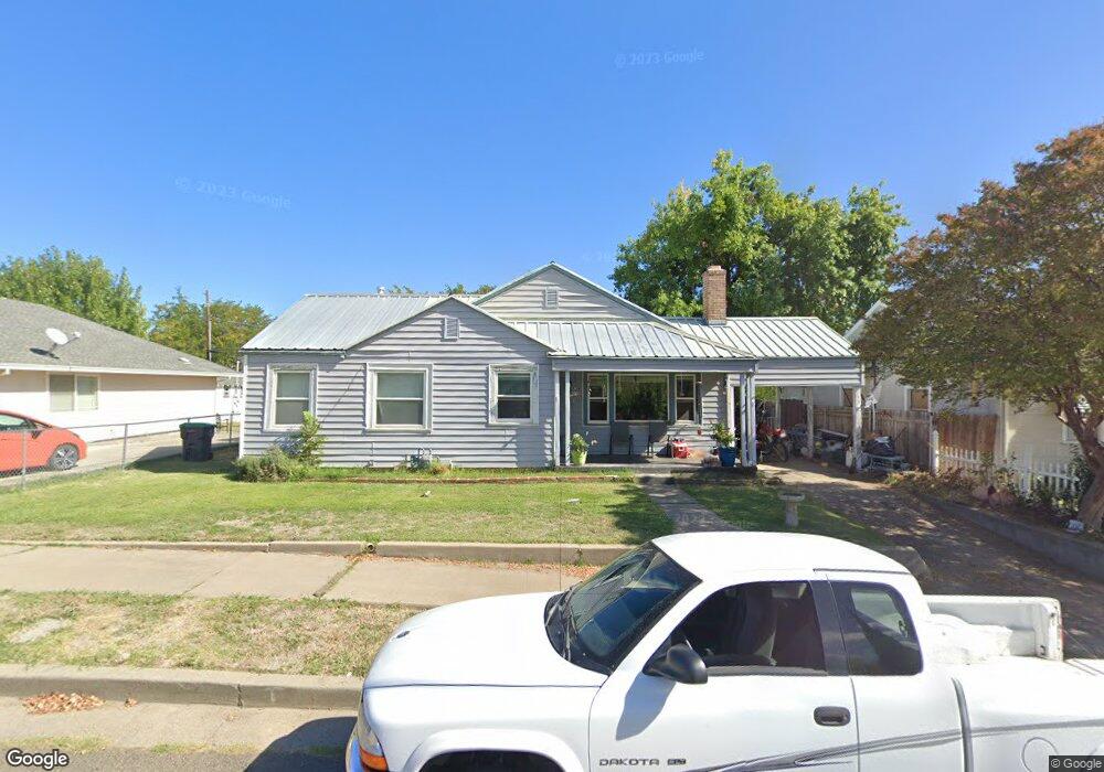
1520 4th St Red Bluff, CA 96080
Estimated Value: $259,000 - $318,000
3
Beds
2
Baths
1,648
Sq Ft
$174/Sq Ft
Est. Value
About This Home
This home is located at 1520 4th St, Red Bluff, CA 96080 and is currently estimated at $286,649, approximately $173 per square foot. 1520 4th St is a home located in Tehama County with nearby schools including Bidwell Elementary School, Vista Preparatory Academy, and Red Bluff High School.
Ownership History
Date
Name
Owned For
Owner Type
Purchase Details
Closed on
Jul 23, 2020
Sold by
Harris John W
Bought by
Harris John William and The John William Harris Trust
Current Estimated Value
Purchase Details
Closed on
Jun 16, 2003
Sold by
Odonnell Harris Margaret E and Odonnell Margaret E
Bought by
Harris John W and Odonnell Harris Margaret E
Home Financials for this Owner
Home Financials are based on the most recent Mortgage that was taken out on this home.
Original Mortgage
$92,000
Interest Rate
5.37%
Mortgage Type
Unknown
Create a Home Valuation Report for This Property
The Home Valuation Report is an in-depth analysis detailing your home's value as well as a comparison with similar homes in the area
Purchase History
| Date | Buyer | Sale Price | Title Company |
|---|---|---|---|
| Harris John William | -- | None Available | |
| Harris John W | -- | Chicago Title Co |
Source: Public Records
Mortgage History
| Date | Status | Borrower | Loan Amount |
|---|---|---|---|
| Closed | Harris John W | $92,000 |
Source: Public Records
Tax History
| Year | Tax Paid | Tax Assessment Tax Assessment Total Assessment is a certain percentage of the fair market value that is determined by local assessors to be the total taxable value of land and additions on the property. | Land | Improvement |
|---|---|---|---|---|
| 2025 | $1,280 | $132,706 | $26,856 | $105,850 |
| 2023 | $1,329 | $127,555 | $25,814 | $101,741 |
| 2022 | $1,321 | $125,055 | $25,308 | $99,747 |
| 2021 | $1,267 | $122,604 | $24,812 | $97,792 |
| 2020 | $1,294 | $121,348 | $24,558 | $96,790 |
| 2019 | $1,302 | $118,970 | $24,077 | $94,893 |
| 2018 | $1,204 | $116,638 | $23,605 | $93,033 |
| 2017 | $1,215 | $114,352 | $23,143 | $91,209 |
| 2016 | $1,135 | $112,111 | $22,690 | $89,421 |
| 2015 | -- | $110,428 | $22,350 | $88,078 |
| 2014 | $1,101 | $108,266 | $21,913 | $86,353 |
Source: Public Records
Map
Nearby Homes
- 1356 Park Ave
- 1359 2nd St
- 1707 Luning St
- 1715 Walbridge St
- 1710 Luning St
- 1426 Lincoln St
- 1549 Jackson St
- 1313 Jackson St
- 1835 Douglass St
- 0 Derby Unit 24724349
- 605 Breckenridge St
- 927 Cedar St
- 1158 Madison St
- 2132 Reta Way
- 0 Ludlow Ave Unit SN25045951
- 545 Cedar St
- 728 Lincoln St
- 0 Jefferson St Unit SN26036140
- 685 Larie Ln
- 846 Rio St
- 1540 4th St
- 1516 4th St
- 1554 4th St
- 1444 Luning St
- 1525 3rd St
- 1515 3rd St
- 1535 3rd St
- 1511 3rd St
- 1535 4th St
- 1415 Walbridge St
- 1525 4th St
- 1505 3rd St
- 1515 Walbridge St
- 1505 4th St
- 1500 Walbridge St
- 1456 4th 1weup7o1l2hu
- 1456 4th St
- 1604 Hill St Unit 1606 Hill Street
- 1604 Hill St
- 1508 Walbridge St
Your Personal Tour Guide
Ask me questions while you tour the home.