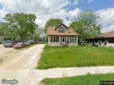
1526 Barton Ave West Bend, WI 53090
Estimated Value: $216,244 - $267,000
3
Beds
1
Bath
1,148
Sq Ft
$208/Sq Ft
Est. Value
About This Home
This home is located at 1526 Barton Ave, West Bend, WI 53090 and is currently estimated at $238,561, approximately $207 per square foot. 1526 Barton Ave is a home located in Washington County with nearby schools including Green Tree Elementary School, Silverbrook Intermediate School, and East High School.
Ownership History
Date
Name
Owned For
Owner Type
Purchase Details
Closed on
May 9, 2019
Sold by
Nummerdor Donald L
Bought by
Jlo Llc
Current Estimated Value
Home Financials for this Owner
Home Financials are based on the most recent Mortgage that was taken out on this home.
Original Mortgage
$15,000
Interest Rate
4%
Mortgage Type
Land Contract Argmt. Of Sale
Purchase Details
Closed on
Apr 18, 2019
Sold by
Marek Linda M
Bought by
Nummerdo Donald L
Home Financials for this Owner
Home Financials are based on the most recent Mortgage that was taken out on this home.
Original Mortgage
$15,000
Interest Rate
4%
Mortgage Type
Land Contract Argmt. Of Sale
Create a Home Valuation Report for This Property
The Home Valuation Report is an in-depth analysis detailing your home's value as well as a comparison with similar homes in the area
Home Values in the Area
Average Home Value in this Area
Purchase History
| Date | Buyer | Sale Price | Title Company |
|---|---|---|---|
| Jlo Llc | $65,000 | None Available | |
| Nummerdo Donald L | $17,000 | Abstract & Title Company |
Source: Public Records
Mortgage History
| Date | Status | Borrower | Loan Amount |
|---|---|---|---|
| Previous Owner | Jlo Llc | $15,000 |
Source: Public Records
Tax History Compared to Growth
Tax History
| Year | Tax Paid | Tax Assessment Tax Assessment Total Assessment is a certain percentage of the fair market value that is determined by local assessors to be the total taxable value of land and additions on the property. | Land | Improvement |
|---|---|---|---|---|
| 2024 | $2,356 | $176,900 | $29,600 | $147,300 |
| 2023 | $2,106 | $133,700 | $30,000 | $103,700 |
| 2022 | $2,416 | $133,700 | $30,000 | $103,700 |
| 2021 | $2,480 | $133,000 | $30,000 | $103,000 |
| 2020 | $2,402 | $133,000 | $30,000 | $103,000 |
| 2019 | $2,335 | $133,000 | $30,000 | $103,000 |
| 2018 | $2,257 | $133,000 | $30,000 | $103,000 |
| 2017 | $2,031 | $108,500 | $30,000 | $78,500 |
| 2016 | $2,049 | $108,500 | $30,000 | $78,500 |
| 2015 | $2,035 | $108,500 | $30,000 | $78,500 |
| 2014 | $2,035 | $108,500 | $30,000 | $78,500 |
| 2013 | $2,200 | $108,500 | $30,000 | $78,500 |
Source: Public Records
Map
Nearby Homes
- 1339 N 11th Ave
- 1714 Fairview Dr
- 1114 Wayne Rd
- 918 Park Ave
- 0 Mint Dr
- 1118 Park Ave
- 1925 N Salisbury Rd
- 690 Rivershores Dr Unit 304
- 690 Rivershores Dr Unit 302
- 739 Shore Ln
- 1168 Park Ave
- 2109 N Salisbury Rd
- 690 North St
- 2149 Briar Dr
- 167 Po St
- 2205 N Salisbury Rd
- Lt1 Dandelion Ln
- 1600 Patricia Dr
- 1104 Green Tree Rd
- 611 North St
- 1526 Barton Ave
- 1513 Monroe St
- 319 Jefferson St
- 1509 Monroe St
- 1507 Monroe St
- 1533 Barton Ave
- 1537 Barton Ave
- 1537 Barton Ave Unit 1539
- 325 Jefferson St
- 1517 Monroe St
- 1523 Barton Ave
- 1517 Barton Ave
- 1503 Monroe St
- 1439 N Main St
- 1543 Barton Ave
- 1454 Barton Ave
- 1547 Barton Ave
- 1551 Barton Ave
- 1450 N Main St
- 1444 Barton Ave