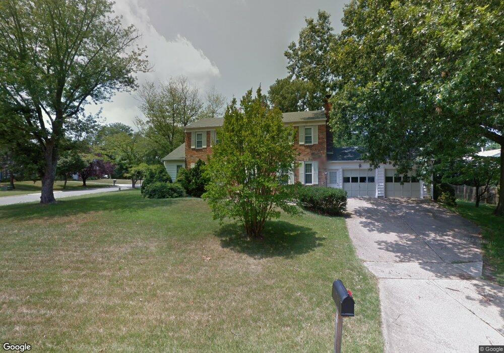
15500 Straughn Dr Laurel, MD 20707
West Laurel NeighborhoodEstimated Value: $587,001 - $611,000
Studio
3
Baths
2,226
Sq Ft
$271/Sq Ft
Est. Value
About This Home
This home is located at 15500 Straughn Dr, Laurel, MD 20707 and is currently estimated at $603,500, approximately $271 per square foot. 15500 Straughn Dr is a home located in Prince George's County with nearby schools including Bond Mill Elementary, Martin Luther King Jr. Middle School, and Laurel High School.
Ownership History
Date
Name
Owned For
Owner Type
Purchase Details
Closed on
Oct 30, 2002
Sold by
Mani Joseph P
Bought by
Mani Joseph P and Mani Dency
Current Estimated Value
Purchase Details
Closed on
Aug 7, 2001
Sold by
Dallas Joseph L
Bought by
Mani Joseph P
Purchase Details
Closed on
Mar 22, 2000
Sold by
Ober Paul R
Bought by
Dallas Joseph L and Dallas Lisa M
Purchase Details
Closed on
Jun 25, 1998
Sold by
Clifton Russell B
Bought by
Ober Paul R and Ober Sondi L
Create a Home Valuation Report for This Property
The Home Valuation Report is an in-depth analysis detailing your home's value as well as a comparison with similar homes in the area
Home Values in the Area
Average Home Value in this Area
Purchase History
| Date | Buyer | Sale Price | Title Company |
|---|---|---|---|
| Mani Joseph P | -- | -- | |
| Mani Joseph P | $245,000 | -- | |
| Dallas Joseph L | $204,000 | -- | |
| Ober Paul R | $199,900 | -- |
Source: Public Records
Tax History
| Year | Tax Paid | Tax Assessment Tax Assessment Total Assessment is a certain percentage of the fair market value that is determined by local assessors to be the total taxable value of land and additions on the property. | Land | Improvement |
|---|---|---|---|---|
| 2025 | $8,058 | $558,100 | $126,400 | $431,700 |
| 2024 | $8,058 | $515,400 | -- | -- |
| 2023 | $7,422 | $472,700 | $0 | $0 |
| 2022 | $6,788 | $430,000 | $101,400 | $328,600 |
| 2021 | $6,503 | $410,833 | $0 | $0 |
| 2020 | $6,218 | $391,667 | $0 | $0 |
| 2019 | $5,933 | $372,500 | $100,700 | $271,800 |
| 2018 | $5,856 | $367,300 | $0 | $0 |
| 2017 | $5,779 | $362,100 | $0 | $0 |
| 2016 | -- | $356,900 | $0 | $0 |
| 2015 | $4,437 | $356,900 | $0 | $0 |
| 2014 | $4,437 | $356,900 | $0 | $0 |
Source: Public Records
Map
Nearby Homes
- 15611 Riding Stable Rd
- 14005 Barkham Ct
- 6003 Windham Rd
- 6201 Goodman Rd
- 7004 Fitzpatrick Dr
- 6918 Scotch Dr
- 7019 Fitzpatrick Dr
- 7002 Scotch Dr
- 4402 Regalwood Terrace
- 7106 Donston Dr
- 16140 Kenny Rd
- 4302 Regalwood Terrace
- 16001 Amina Dr
- 7209 Brooklyn Bridge Rd
- 14706 Saddle Creek Dr
- 15712 Dorset Rd Unit 104
- 15708 Dorset Rd Unit 202
- 15706 Dorset Rd Unit 102
- 14836 Silver Ash Ct
- 14724 Crosswood Terrace
- 6008 Wiss Dr
- 15504 Straughn Dr
- 15919 Jerald Rd
- 6006 Wiss Dr
- 15503 Straughn Dr
- 15501 Straughn Dr
- 15420 Straughn Dr
- 15505 Straughn Dr
- 6009 Wiss Dr
- 15411 Straughn Dr
- 15917 Jerald Rd
- 6007 Wiss Dr
- 15409 Straughn Dr
- 16010 Kent Rd
- 15512 Straughn Dr
- 15915 Jerald Rd
- 16012 Kent Rd
- 15400 Straughn Dr
- 15918 Jerald Rd
- 16008 Kent Rd
Your Personal Tour Guide
Ask me questions while you tour the home.