15690 Oakridge Rd Corning, CA 96021
Estimated payment $62/month
About This Lot
--- Land Galore! Grab It Before Gone! ---
-----------------------------------------------
--- Contact us now! ---
-----------------------------------------------
Act now to secure your slice of California paradise!
With some flat area just off the street, this prime property is ready for your dream home or investment venture.
With power conveniently located at the lot line, building is a breeze. Nestled in the vibrant Rancho Tehama Reserve community, you'll enjoy a blend of tranquility and vibrant social opportunities.
Whether you choose cash or take advantage of our owner financing options, this incredible opportunity won't last long.
-----------------------------------------------
Pricing:
Discounted Cash Price: $7,997, Or;
Owner Financing Available: $349, then just $249/month for 96 months.
*No credit check!
*No income verification!
*Everyone qualifies!
*No Realtors fees
-----------------------------------------------
--- To ask questions or to reserve the property, submit an inquiry NOW! ---
-----------------------------------------------
Property Details:
Assessor's Parcel Number (APN): 062-360-012-000
County: Tehama
Subdivision: Rancho Tehama Reserved
Annual Property Taxes: $226.04
HOA: Rancho Tehama Reserve
HOA Dues: $70/month
Legal Description: LOT 757 TR 1000 RTS #2 EX M/R
Terrain Type: Wooded / Slope / Hill
Views From Property: Plain landscaping
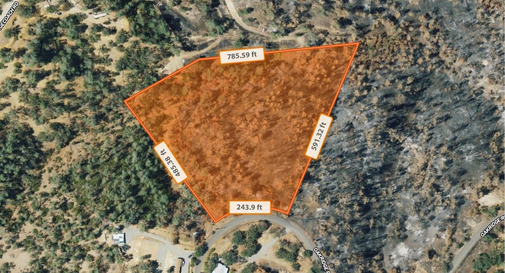
Lot Dimensions:
*785.59 feet North
*591.32 feet East
*243.9 feet South
*485.38 feet West
Elevation: 980 Ft
GPS Coordinates (Center): 40.002081, -122.454038
GPS Coordinates (4 Corners):
*40.002932, -122.452755 NE
*40.001436, -122.453563 SE
*40.001368, -122.454389 SW
*40.002422, -122.455430 NW
GPS Coordinate Instructions: Paste one set of coordinates at a time into Google Maps for precise property location & directions. Need assistance? Feel free to reach out we're here to help!
City or County Limits: County
School District: Corning Union Elementary School District / Corning Union High School District
Conveyance: Grant Deed
Access: Legal & Physical Access. Oakridge Rd
Road Type: Gravel
No liens.
No back taxes.
-----------------------------------------------
--- Questions? Submit an inquiry! ---
-----------------------------------------------
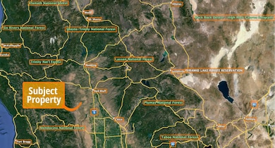
Location, location, location!
Closest Highway: West Side Hwy
Closest Major City: Chico, California (58 min (50.0 miles)
Closest Small Town: Corning, California (33 min (23.8 miles)
Closest Gas Station: G&K Country Store, 17585 Rancho Tehama Rd (9 min (4.3 miles)
Nearby Attractions:
*Racho Tehama Community Park, Corning, CA 96021 (7 min (3.4 miles)
*Pebble Beach Creek Access, Red Bluff, CA 96080 (6 min (2.7 miles)
*Government Gulch, Park Terrace, Corning, CA 96021 (11 min (4.9 miles)
-----------------------------------------------
Zoning & Use Information (Deemed reliable, but not guaranteed. Buyer to verify with County):
Zoning/Property Use Code: RESIDENTIAL ESTATE DISTRICT RE-BZ
What can be built (per county): Single Family Dwelling
Time to Build: The permit will remain valid for six months, during this time an inspection is required otherwise, it will expire.
Camping Allowed: Per County, No Per HOA, No
RVs Allowed: Per County, No Per HOA, it can be stored as long as you are not living in it
Mobile Homes Allowed: Per County, Yes Per HOA, Yes
Tiny Homes Allowed: Per County, No Per HOA, minimum dwelling size allowed is 800 sq. feet
Short Term Vacation Rentals Allowed: Per County, No Per HOA, Yes
-----------------------------------------------
Utility Details:
Water: Would have to drill a well.
Sewer/Septic: Would have to install a septic.
Electric: Would have to contact Pacific Gas and Electric Company.
Gas: Would have to contact Triple R Gas, Suburban Propane, etc.
Waste: Would have to contact Rancho Tehama Transfer Station.
Utility Notes: Per County Planner & HOA, water and sewer is not available, well and septic required.
-----------------------------------------------
Buyer is responsible for performing due diligence. This may include but is not limited to: visiting the property, contacting the governing City and/or County to confirm use and zoning, and that this fits with the buyer's needs and intentions. All information in this ad is deemed reliable however not guaranteed. It is the responsibility of the buyer to confirm all, and satisfy any & all concerns prior to purchasing. Some photos in this ad may not be of the subject property, but may be included to showcase features of the area. Seller has a CA real estate license. Please contact us with any questions.
--- Thank you for your interest. ---
Achieve Co.
Listed on: 06/04/2025

Property Details
Property Type
- Land
Est. Annual Taxes
- $226
Map
Home Values in the Area
Average Home Value in this Area
Tax History
| Year | Tax Paid | Tax Assessment Tax Assessment Total Assessment is a certain percentage of the fair market value that is determined by local assessors to be the total taxable value of land and additions on the property. | Land | Improvement |
|---|---|---|---|---|
| 2023 | $226 | $21,037 | $21,037 | $0 |
| 2022 | $223 | $20,625 | $20,625 | $0 |
| 2021 | $213 | $20,221 | $20,221 | $0 |
| 2020 | $215 | $20,014 | $20,014 | $0 |
| 2019 | $206 | $19,622 | $19,622 | $0 |
| 2018 | $206 | $19,238 | $19,238 | $0 |
| 2017 | $205 | $18,861 | $18,861 | $0 |
| 2016 | $191 | $18,492 | $18,492 | $0 |
| 2015 | -- | $18,215 | $18,215 | $0 |
| 2014 | $144 | $13,728 | $13,728 | $0 |
Property History
| Date | Event | Price | Change | Sq Ft Price |
|---|---|---|---|---|
| 06/04/2025 06/04/25 | For Sale | $7,997 | -- | -- |
Purchase History
| Date | Type | Sale Price | Title Company |
|---|---|---|---|
| Grant Deed | $2,000 | None Listed On Document | |
| Grant Deed | $5,500 | Southland Title | |
| Interfamily Deed Transfer | -- | Southland Title | |
| Grant Deed | $5,500 | -- | |
| Grant Deed | $1,500 | Chicago Title Co |
Mortgage History
| Date | Status | Loan Amount | Loan Type |
|---|---|---|---|
| Previous Owner | $30,000 | Unknown |
- 16387 Stagecoach Rd
- 16432 Stagecoach Rd
- 6989 Horseshoe Dr
- 00 Horseshoe Dr
- 16405 Hillcrest Dr
- 7293 Hawk Ct
- 7356 Knoll Dr
- 7425 Rainbow
- 16495 Hillcrest Dr Unit Lot 1269
- 16495 Hillcrest Dr
- 16298 Lariat Loop Unit Lot 127
- 16298 Lariat Loop
- 16887 Stagecoach Rd
- 17007 Stagecoach Rd
- 16220 Rancho Tehama Rd
- 16164 Nugget Rd
- 16475 Oakridge Rd Unit Lot 865
- 16475 Oakridge Rd
- 16015 Apache Trail Unit Lot 1141
- 16015 Apache Trail


