1573 N 1100 Rd Lawrence, KS 66046
Estimated payment $3,746/month
Highlights
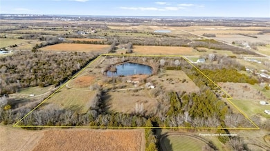
- 1,051,974 Sq Ft lot
- Pond
- Wooded Lot
- Deck
- Great Room with Fireplace
- Traditional Architecture
About This Home
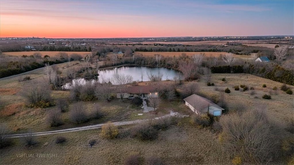
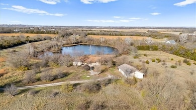
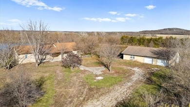
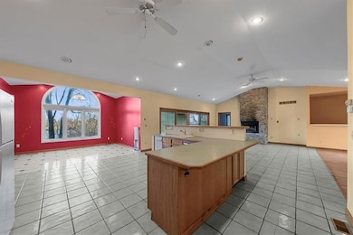
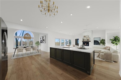
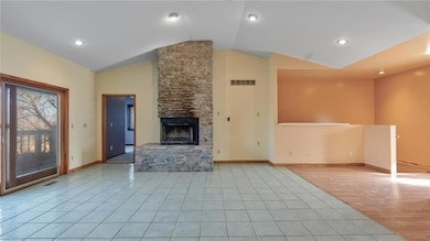
Escape to private, picturesque, and close-in country living with endless possibilities. Tucked away on a beautiful 24 acre setting on paved roads just outside the city limits of Lawrence, KS, this unique property offers a mix of mature woodlands, open pastures, a large pond and plentiful wildlife. At the center of this gorgeous land is a charming stucco, 2 bedroom, 2.5 bath, true ranch home offering 2146 sq. ft of main floor living area, an open floor plan with a large open great room with wood burning fireplace, an open kitchen with stained cabinets, an island with breakfast bar, a pantry, all appliances and a dining room with large radius picture window overlooking the gorgeous views of the pond. Rounding out the main level is a master suite with vaulted ceiling, large walk-in closet with built-ins, a master bath with stacked washer/dryer, jetted tub, walk-in shower, and water closet; an additional guest bedroom, a full bath with tiled shower/tub, and a half bath off the kitchen. The full walk-out basement was originally finished with an additional 1100 sq. ft. of living area including a recreation room, family room, 3rd bedroom, full bath and ample storage areas, but due to a water leak with subsequent mold, the basement has been remediated with floor and wall coverings removed down to the studs, which now await your personal decorative touches. Don't forget the matching stucco outbuilding/workshop/garage which offers a kitchenette, an office, a full bathroom, a mini-split HVAC and 4 overhead garage doors for all your cars, equipment and workshop needs. Whether you’re envisioning a hobby farm, renovating the existing home, building your dream home, a quiet weekend retreat or a place to enjoy hunting, fishing, ATV’s, riding horses and exploring nature, this property awaits your decorative vision to create a lifestyle worth dreaming about. Don't miss this opportunity to Bid Your Price. Bidding Ends: December 30 at 1:00 pm.
Listing Agent
Cates Auction & Realty Co Inc Brokerage Phone: 816-868-4321 License #2005030145 Listed on: 12/01/2025
Co-Listing Agent
Cates Auction & Realty Co Inc Brokerage Phone: 816-868-4321 License #2021018389
Home Details
Home Type
- Single Family
Est. Annual Taxes
- $7,105
Year Built
- Built in 1999
Lot Details
- 24.15 Acre Lot
- Paved or Partially Paved Lot
- Wooded Lot
Parking
- 3 Car Detached Garage
Home Design
- Traditional Architecture
- Frame Construction
- Composition Roof
- Stucco
Interior Spaces
- Ceiling Fan
- Thermal Windows
- Great Room with Fireplace
- 2 Fireplaces
- Formal Dining Room
- Fire and Smoke Detector
- Laundry on main level
Kitchen
- Dishwasher
- Kitchen Island
- Wood Stained Kitchen Cabinets
Flooring
- Carpet
- Tile
Bedrooms and Bathrooms
- 2 Bedrooms
- Main Floor Bedroom
- Walk-In Closet
- Spa Bath
Finished Basement
- Partial Basement
- Fireplace in Basement
Outdoor Features
- Pond
- Deck
- Porch
Utilities
- Forced Air Heating and Cooling System
- Septic Tank
Community Details
- No Home Owners Association
Listing and Financial Details
- Assessor Parcel Number 023-109-29-0-00-00-001.08-0
- $0 special tax assessment
Map
Home Values in the Area
Average Home Value in this Area
Tax History
| Year | Tax Paid | Tax Assessment Tax Assessment Total Assessment is a certain percentage of the fair market value that is determined by local assessors to be the total taxable value of land and additions on the property. | Land | Improvement |
|---|---|---|---|---|
| 2025 | $6,226 | $57,914 | $18,147 | $39,767 |
| 2024 | $6,226 | $56,776 | $17,572 | $39,204 |
| 2023 | $6,057 | $53,211 | $16,422 | $36,789 |
| 2022 | $5,842 | $49,957 | $14,778 | $35,179 |
| 2021 | $4,902 | $40,837 | $13,384 | $27,453 |
| 2020 | $4,727 | $39,721 | $13,384 | $26,337 |
| 2019 | $4,123 | $34,730 | $9,934 | $24,796 |
| 2018 | $4,187 | $34,935 | $9,853 | $25,082 |
| 2017 | $2,093 | $34,304 | $9,853 | $24,451 |
| 2016 | $0 | $32,799 | $5,854 | $26,945 |
| 2015 | -- | $32,051 | $5,854 | $26,197 |
| 2014 | -- | $31,235 | $5,854 | $25,381 |
Property History
| Date | Event | Price | List to Sale | Price per Sq Ft |
|---|---|---|---|---|
| 12/01/2025 12/01/25 | For Sale | $599,000 | -- | $185 / Sq Ft |
Purchase History
| Date | Type | Sale Price | Title Company |
|---|---|---|---|
| Warranty Deed | -- | Kansas Secured Title |
Mortgage History
| Date | Status | Loan Amount | Loan Type |
|---|---|---|---|
| Open | $290,800 | Purchase Money Mortgage |
Source: Heartland MLS
MLS Number: 2589705
APN: 1092900000001080
Disclaimer: Certain information contained herein is derived from information provided by parties other than Homes.com. All information provided is deemed reliable, but is not guaranteed to be accurate and should be independently verified.
![]() Based on information submitted to the MLS GRID as of [see last changed date above]. All data is obtained from various sources and may not have been verified by broker or MLS GRID. Supplied Open House Information is subject to change without notice. All information should be independently reviewed and verified for accuracy. Properties may or may not be listed by the office/agent presenting the information. Some IDX listings have been excluded from this website. Prices displayed on all Sold listings are the Last Known Listing Price and may not be the actual selling price.
Based on information submitted to the MLS GRID as of [see last changed date above]. All data is obtained from various sources and may not have been verified by broker or MLS GRID. Supplied Open House Information is subject to change without notice. All information should be independently reviewed and verified for accuracy. Properties may or may not be listed by the office/agent presenting the information. Some IDX listings have been excluded from this website. Prices displayed on all Sold listings are the Last Known Listing Price and may not be the actual selling price.
Listing Information presented by local MLS brokerage: TEN-X, INC., local REALTOR®- Arlene Richardson - (888)952-6393
The Digital Millennium Copyright Act of 1998, 17 U.S.C. § 512 (the “DMCA”) provides recourse for copyright owners who believe that material appearing on the Internet infringes their rights under U.S. copyright law. If you believe in good faith that any content or material made available in connection with our website or services infringes your copyright, you (or your agent) may send us a notice requesting that the content or material be removed, or access to it blocked.
Notices must be sent in writing by email to DMCAnotice@MLSGrid.com.
The DMCA requires that your notice of alleged copyright infringement include the following information:
(1) description of the copyrighted work that is the subject of claimed infringement;
(2) description of the alleged infringing content and information sufficient to permit us to locate the content;
(3) contact information for you, including your address, telephone number and email address;
(4) a statement by you that you have a good faith belief that the content in the manner complained of is not authorized by the copyright owner, or its agent, or by the operation of any law;
(5) a statement by you, signed under penalty of perjury, that the information in the notification is accurate and that you have the authority to enforce the copyrights that are claimed to be infringed; and
(6) a physical or electronic signature of the copyright owner or a person authorized to act on the copyright owner’s behalf. Failure to include all of the above information may result in the delay of the processing of your complaint.
- 2510 Marcia Ln
- 1605 N 1037 Rd
- 39ac 0000 N 1000 Rd
- 39 ac 0000 N 1000 Rd
- 1053 E 1479 Rd
- 1072 E 1466 Rd
- 0000 E 1700 Rd
- 20 acres m/l E 1700 Rd
- aaa E 1700 Rd
- 20 ac E 1700 Rd
- 5ac 0000 N 1000 Rd
- 2925 Whitmore Dr
- 2900 & 2905 Haskell Ln
- 1548 N 800th Rd
- 1524 E 28th Terrace
- 2736 Bonanza St
- 2731 Bonanza St
- 2726 Bonanza St
- 2706 Bonanza St
- 2701 Lankford Dr
- 2725 Ponderosa Dr
- 2641 Maverick Ln
- 3250 Michigan St
- 3345 Magnolia Cir
- 2201 Harper Square Apartments
- 2411 Louisiana St
- 1609 W 26th St
- 2511 W 31st St
- 2522-2530 Redbud Ln
- 2310 W 26th St
- 2401 W 25th St
- 1733 Massachusetts St
- 1645 Kentucky St
- 1735 W 19th St
- 1942 Stewart Ave
- 1423 Ohio St
- 1433 Ohio St
- 1330 Vermont St
- 1220 Louisiana St Unit . 1
- 1201-1205 Oread Ave
