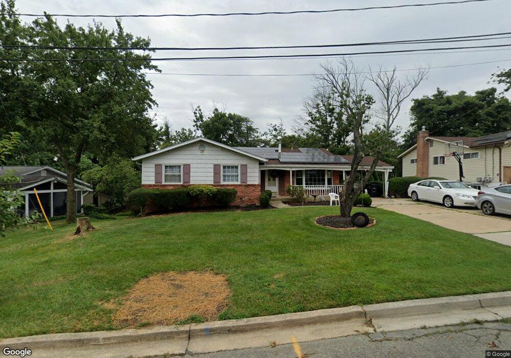
15810 Kerr Rd Laurel, MD 20707
West Laurel NeighborhoodEstimated Value: $475,000 - $554,000
4
Beds
3
Baths
1,460
Sq Ft
$352/Sq Ft
Est. Value
About This Home
This home is located at 15810 Kerr Rd, Laurel, MD 20707 and is currently estimated at $513,548, approximately $351 per square foot. 15810 Kerr Rd is a home located in Prince George's County with nearby schools including Bond Mill Elementary, Martin Luther King Jr. Middle School, and Laurel High School.
Ownership History
Date
Name
Owned For
Owner Type
Purchase Details
Closed on
Feb 23, 2006
Sold by
Kangethe Rose N
Bought by
Kangethe Rose N Etal
Current Estimated Value
Purchase Details
Closed on
Oct 24, 2005
Sold by
Kangethe Rose N
Bought by
Kangethe Rose N Etal
Home Financials for this Owner
Home Financials are based on the most recent Mortgage that was taken out on this home.
Original Mortgage
$365,000
Interest Rate
7.87%
Mortgage Type
Stand Alone Refi Refinance Of Original Loan
Purchase Details
Closed on
Sep 8, 2004
Sold by
Kunde Virgil G
Bought by
Kangethe Rose N
Create a Home Valuation Report for This Property
The Home Valuation Report is an in-depth analysis detailing your home's value as well as a comparison with similar homes in the area
Home Values in the Area
Average Home Value in this Area
Purchase History
| Date | Buyer | Sale Price | Title Company |
|---|---|---|---|
| Kangethe Rose N Etal | -- | -- | |
| Kangethe Rose N Etal | -- | -- | |
| Kangethe Rose N | $325,000 | -- |
Source: Public Records
Mortgage History
| Date | Status | Borrower | Loan Amount |
|---|---|---|---|
| Previous Owner | Kangethe Rose N Etal | $365,000 |
Source: Public Records
Tax History
| Year | Tax Paid | Tax Assessment Tax Assessment Total Assessment is a certain percentage of the fair market value that is determined by local assessors to be the total taxable value of land and additions on the property. | Land | Improvement |
|---|---|---|---|---|
| 2025 | $5,566 | $431,800 | $126,500 | $305,300 |
| 2024 | $5,566 | $402,333 | -- | -- |
| 2023 | $4,146 | $372,867 | $0 | $0 |
| 2022 | $5,037 | $343,400 | $101,500 | $241,900 |
| 2021 | $4,816 | $327,133 | $0 | $0 |
| 2020 | $4,709 | $310,867 | $0 | $0 |
| 2019 | $4,575 | $294,600 | $100,700 | $193,900 |
| 2018 | $4,490 | $293,433 | $0 | $0 |
| 2017 | $4,432 | $292,267 | $0 | $0 |
| 2016 | -- | $291,100 | $0 | $0 |
| 2015 | $3,821 | $280,633 | $0 | $0 |
| 2014 | $3,821 | $270,167 | $0 | $0 |
Source: Public Records
Map
Nearby Homes
- 7004 Fitzpatrick Dr
- 7019 Fitzpatrick Dr
- 7002 Scotch Dr
- 6918 Scotch Dr
- 16140 Kenny Rd
- 15712 Dorset Rd Unit 104
- 7106 Donston Dr
- 6504 Walker Branch Dr
- 15708 Dorset Rd Unit 202
- 15706 Dorset Rd Unit 102
- 7209 Brooklyn Bridge Rd
- 6201 Goodman Rd
- 15603 Dorset Rd Unit 101
- 6003 Windham Rd
- 15743 Millbrook Ln
- 7208 Cherry Ln
- 14005 Barkham Ct
- 15046 Cherrywood Dr
- 7620 S Arbory Ln
- 15020 Cherrywood Dr
Your Personal Tour Guide
Ask me questions while you tour the home.