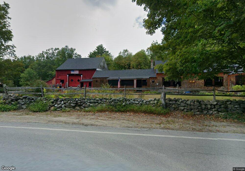
1588 Center Rd Lyndeborough, NH 03082
Greenfield NeighborhoodEstimated Value: $820,669 - $879,000
4
Beds
3
Baths
2,567
Sq Ft
$333/Sq Ft
Est. Value
About This Home
This home is located at 1588 Center Rd, Lyndeborough, NH 03082 and is currently estimated at $855,917, approximately $333 per square foot. 1588 Center Rd is a home located in Hillsborough County with nearby schools including Lyndeborough Central School, Wilton-Lyndeborough Cooperative Middle School, and Wilton-Lyndeborough Cooperative High School.
Ownership History
Date
Name
Owned For
Owner Type
Purchase Details
Closed on
Aug 6, 2025
Sold by
Falcioni Kevin and Falcioni Donna
Bought by
Kevin W Falcioni Lt and Falcioni
Current Estimated Value
Purchase Details
Closed on
Jul 1, 2020
Sold by
Long Julie A
Bought by
Cel Rt
Purchase Details
Closed on
Jul 26, 2017
Sold by
Kln Contruction Co Inc
Bought by
Long Julie A
Home Financials for this Owner
Home Financials are based on the most recent Mortgage that was taken out on this home.
Original Mortgage
$373,000
Interest Rate
3.91%
Mortgage Type
Purchase Money Mortgage
Create a Home Valuation Report for This Property
The Home Valuation Report is an in-depth analysis detailing your home's value as well as a comparison with similar homes in the area
Home Values in the Area
Average Home Value in this Area
Purchase History
| Date | Buyer | Sale Price | Title Company |
|---|---|---|---|
| Kevin W Falcioni Lt | -- | -- | |
| Kevin W Falcioni Lt | -- | -- | |
| Cel Rt | -- | None Available | |
| Cel Rt | -- | None Available | |
| Long Julie A | $467,466 | -- | |
| Long Julie A | $467,466 | -- |
Source: Public Records
Mortgage History
| Date | Status | Borrower | Loan Amount |
|---|---|---|---|
| Previous Owner | Long Julie A | $373,000 |
Source: Public Records
Tax History Compared to Growth
Tax History
| Year | Tax Paid | Tax Assessment Tax Assessment Total Assessment is a certain percentage of the fair market value that is determined by local assessors to be the total taxable value of land and additions on the property. | Land | Improvement |
|---|---|---|---|---|
| 2024 | $10,757 | $653,900 | $171,700 | $482,200 |
| 2023 | $10,253 | $653,900 | $171,700 | $482,200 |
| 2022 | $9,606 | $653,900 | $171,700 | $482,200 |
| 2021 | $9,955 | $459,400 | $116,100 | $343,300 |
| 2020 | $9,747 | $456,100 | $116,100 | $340,000 |
| 2019 | $9,355 | $461,300 | $116,100 | $345,200 |
| 2018 | $9,272 | $461,300 | $116,100 | $345,200 |
| 2017 | $9,692 | $491,500 | $116,100 | $375,400 |
Source: Public Records
Map
Nearby Homes
- 222 Forest Rd
- 24 Glass Factory Rd
- 757 Forest Rd
- 94 Summit Dr
- 57 Richardson Rd
- A 66 Burton Hwy
- 16 Cameron's Way
- 496 Mountain Rd
- 11 Pony Farm Ln
- 372 Webster Hwy
- 19 Putnam Rd
- 75 New Boston Rd
- 79 Salisbury Rd
- 2 Wallace Ln
- 9 Beacon Ln
- 65 Webster Hwy
- 0 Marden Rd
- 59 Goldsmith Rd
- 60 Goldsmith Rd
- 27 Island St