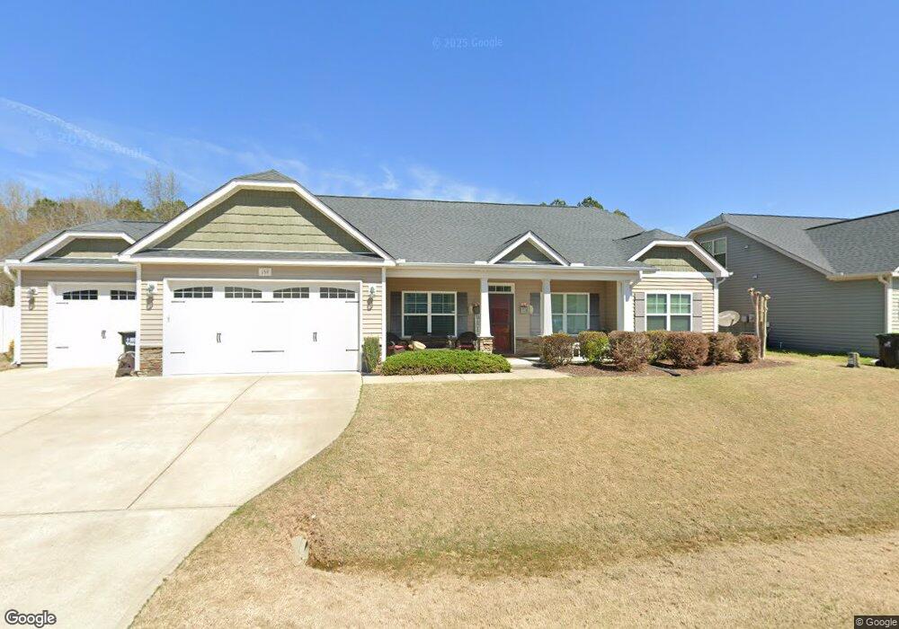
159 Red Angus Dr Smithfield, NC 27577
Cleveland NeighborhoodEstimated Value: $485,000 - $544,000
4
Beds
3
Baths
3,102
Sq Ft
$165/Sq Ft
Est. Value
About This Home
This home is located at 159 Red Angus Dr, Smithfield, NC 27577 and is currently estimated at $511,140, approximately $164 per square foot. 159 Red Angus Dr is a home with nearby schools including Polenta Elementary School, Swift Creek Middle, and Cleveland High School.
Ownership History
Date
Name
Owned For
Owner Type
Purchase Details
Closed on
Nov 9, 2016
Sold by
Cates Building Inc
Bought by
Ancheta Robert and Ancheta Robin N
Current Estimated Value
Home Financials for this Owner
Home Financials are based on the most recent Mortgage that was taken out on this home.
Original Mortgage
$285,757
Outstanding Balance
$229,413
Interest Rate
3.42%
Mortgage Type
New Conventional
Estimated Equity
$281,727
Create a Home Valuation Report for This Property
The Home Valuation Report is an in-depth analysis detailing your home's value as well as a comparison with similar homes in the area
Home Values in the Area
Average Home Value in this Area
Purchase History
| Date | Buyer | Sale Price | Title Company |
|---|---|---|---|
| Ancheta Robert | $283,000 | None Available |
Source: Public Records
Mortgage History
| Date | Status | Borrower | Loan Amount |
|---|---|---|---|
| Open | Ancheta Robert | $285,757 |
Source: Public Records
Tax History
| Year | Tax Paid | Tax Assessment Tax Assessment Total Assessment is a certain percentage of the fair market value that is determined by local assessors to be the total taxable value of land and additions on the property. | Land | Improvement |
|---|---|---|---|---|
| 2025 | $3,129 | $492,770 | $75,000 | $417,770 |
| 2024 | $2,392 | $295,250 | $50,000 | $245,250 |
| 2023 | $2,310 | $295,250 | $50,000 | $245,250 |
| 2022 | $2,428 | $295,250 | $50,000 | $245,250 |
| 2021 | $2,428 | $295,250 | $50,000 | $245,250 |
| 2020 | $2,458 | $295,250 | $50,000 | $245,250 |
| 2019 | $2,458 | $295,250 | $50,000 | $245,250 |
| 2018 | $2,330 | $273,360 | $30,000 | $243,360 |
| 2017 | $2,330 | $273,360 | $30,000 | $243,360 |
| 2016 | $256 | $30,000 | $30,000 | $0 |
Source: Public Records
Map
Nearby Homes
- 2411 Freedom Rd
- 80 Independence Dr
- 15 Independence Dr
- 107 Smithsanders Ct
- Colfax Plan at High Springs
- Roanoke Plan at High Springs
- Cooper Plan at High Springs
- Davidson Plan at High Springs
- Asheboro Plan at High Springs
- McDowell Plan at High Springs
- Waverly Plan at High Springs
- 79 Quail Point Cir
- 250 Rising Star Dr
- 100 Brodie Rose Landing Way
- 192 Quail Point Cir
- 447 Rising Star Dr
- 91 Kitty Branch Way
- 474 Ashpole Trail
- 338 Pedernales Dr
- 41 Brodie Rose Landing Way
- 185 Red Angus Dr
- 178 Red Angus Dr
- 146 Red Angus Dr
- 194 Red Angus Dr
- 199 Red Angus Dr
- 121 Red Angus Dr
- 128 Red Angus Dr
- 200 Red Angus Dr
- 205 Red Angus Dr
- 204 Red Angus Dr
- 101 Red Angus Dr
- 96 Red Angus Dr
- 78 Red Angus Dr
- 588 Polenta Rd
- 63 Black Horse Way
- 54 Black Horse Way
- 54 Black Horse Way
- 544 Polenta Rd
- 65 Red Angus Dr
- 45 Red Angus Dr