
Seller's Agent in 2025
Jennifer Rogness
Epique Realty
(715) 821-1952
1 in this area
110 Total Sales
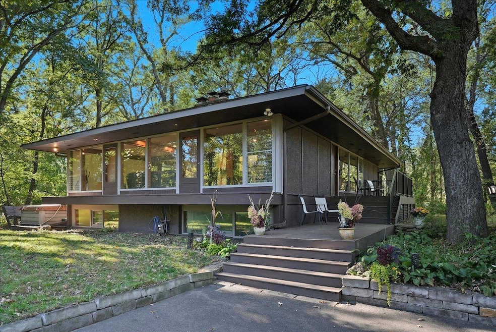


Experience the perfect blend of privacy and modern design in this stunning Prairie-style contemporary home set on 1.75 wooded acres in beautiful North Oaks. This spacious one-level residence with a finished basement, features 4 bedrooms and 3 bathrooms, with all living spaces conveniently on the main floor—ideal for comfortable everyday living and effortless entertaining. Enjoy stunning Brazilian cherry hardwood floors, abundant natural light from multiple skylights, and a stylish European kitchen with a large center island—perfect for gatherings. The home offers two cozy wood-burning fireplaces, creating warm, inviting spaces throughout. Step outside onto several decks surrounded by mature trees, or relax by the fire pit under the stars. Additional features include a detached garage, shed, treehouse, and a new septic system and well pump. Residents of North Oaks enjoy access to Pleasant Lake, complete with a public beach, kayaks, and paddle boats. Explore scenic walking, running, and ski trails, and take advantage of nearby parks and tennis courts. A true retreat just minutes from city conveniences—this home is where nature, style, and function meet. New Septic 2021. Well upgrades/improvements 2024. A few additional notes on the European-style kitchen: This kitchen was designed by a professional chef and restaurant owner. It is a blend of form, function, everyday living, and the natural constraints of the house. The former owners loved to entertain and one of the issues was everybody ended up in the kitchen.
Which didn't sit well with a busy cantankerous cook. So the large island was installed with views of the outside, and it kept people to the side. The small island was chosen to preserve his work triangle, and is a great place for a quick meal.
| Date | Type | Sale Price | Title Company |
|---|---|---|---|
| Warranty Deed | $685,000 | Legacy Title | |
| Deed | -- | None Listed On Document | |
| Quit Claim Deed | -- | Land Title Inc |
| Date | Status | Loan Amount | Loan Type |
|---|---|---|---|
| Open | $650,750 | New Conventional | |
| Previous Owner | $488,000 | New Conventional |
| Date | Event | Price | List to Sale | Price per Sq Ft |
|---|---|---|---|---|
| 12/19/2025 12/19/25 | Sold | $685,000 | 0.0% | $224 / Sq Ft |
| 12/16/2025 12/16/25 | Pending | -- | -- | -- |
| 11/12/2025 11/12/25 | Price Changed | $684,900 | -2.1% | $224 / Sq Ft |
| 10/15/2025 10/15/25 | For Sale | $699,900 | -- | $228 / Sq Ft |
| Year | Tax Paid | Tax Assessment Tax Assessment Total Assessment is a certain percentage of the fair market value that is determined by local assessors to be the total taxable value of land and additions on the property. | Land | Improvement |
|---|---|---|---|---|
| 2025 | $6,462 | $599,700 | $250,000 | $349,700 |
| 2023 | $6,462 | $533,000 | $250,000 | $283,000 |
| 2022 | $5,410 | $517,100 | $260,000 | $257,100 |
| 2021 | $5,800 | $422,600 | $190,700 | $231,900 |
| 2020 | $6,182 | $461,700 | $190,700 | $271,000 |
| 2019 | $4,750 | $461,800 | $190,700 | $271,100 |
| 2018 | $4,202 | $384,100 | $190,700 | $193,400 |
| 2017 | $4,704 | $350,400 | $190,700 | $159,700 |
| 2016 | $4,812 | $0 | $0 | $0 |
| 2015 | $4,838 | $375,400 | $190,700 | $184,700 |
| 2014 | $5,188 | $0 | $0 | $0 |
Seller's Agent in 2025
Jennifer Rogness
Epique Realty
(715) 821-1952
1 in this area
110 Total Sales
P
Buyer's Agent in 2025
Patrick Carson
DRG
(612) 254-0149
1 in this area
198 Total Sales
Source: NorthstarMLS
MLS Number: 6799351
APN: 17-30-22-12-0009
Disclaimer: Certain information contained herein is derived from information provided by parties other than Homes.com. All information provided is deemed reliable, but is not guaranteed to be accurate and should be independently verified.
![]() Based on information submitted to the MLS GRID. All data is obtained from various sources and may not have been verified by broker or MLS GRID. Supplied Open House Information is subject to change without notice. All information should be independently reviewed and verified for accuracy. Properties may or may not be listed by the office/agent presenting the information. Some IDX listings have been excluded from this website.
Based on information submitted to the MLS GRID. All data is obtained from various sources and may not have been verified by broker or MLS GRID. Supplied Open House Information is subject to change without notice. All information should be independently reviewed and verified for accuracy. Properties may or may not be listed by the office/agent presenting the information. Some IDX listings have been excluded from this website.
Based on information submitted to the MLS GRID
Ask me questions while you tour the home.