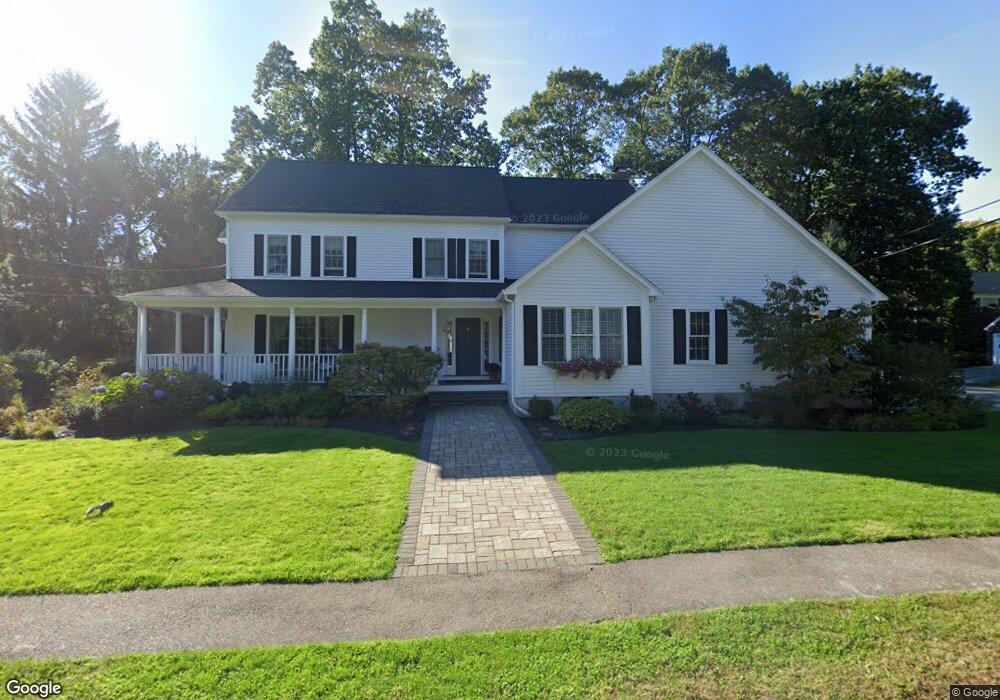
16 Woodledge Rd Needham, MA 02492
Estimated Value: $1,431,000 - $2,049,962
4
Beds
4
Baths
1,636
Sq Ft
$1,116/Sq Ft
Est. Value
About This Home
This home is located at 16 Woodledge Rd, Needham, MA 02492 and is currently estimated at $1,824,991, approximately $1,115 per square foot. 16 Woodledge Rd is a home located in Norfolk County with nearby schools including Mitchell Elementary School, High Rock Middle School, and Pollard Middle School.
Ownership History
Date
Name
Owned For
Owner Type
Purchase Details
Closed on
Aug 6, 1997
Sold by
Piersiak William J
Bought by
Miller Edward G and Miller Jodi B
Current Estimated Value
Home Financials for this Owner
Home Financials are based on the most recent Mortgage that was taken out on this home.
Original Mortgage
$455,200
Outstanding Balance
$67,989
Interest Rate
7.5%
Mortgage Type
Purchase Money Mortgage
Estimated Equity
$1,757,002
Purchase Details
Closed on
Jan 30, 1997
Sold by
Floyd Joseph J and Floyd Janet M
Bought by
Piersiak William J
Home Financials for this Owner
Home Financials are based on the most recent Mortgage that was taken out on this home.
Original Mortgage
$399,200
Interest Rate
7.65%
Mortgage Type
Purchase Money Mortgage
Purchase Details
Closed on
Mar 28, 1994
Sold by
Corcoran Janet M
Bought by
Floyd Joseph J and Floyd Janet M
Create a Home Valuation Report for This Property
The Home Valuation Report is an in-depth analysis detailing your home's value as well as a comparison with similar homes in the area
Home Values in the Area
Average Home Value in this Area
Purchase History
| Date | Buyer | Sale Price | Title Company |
|---|---|---|---|
| Miller Edward G | $569,000 | -- | |
| Miller Edward G | $569,000 | -- | |
| Piersiak William J | $232,000 | -- | |
| Piersiak William J | $232,000 | -- | |
| Floyd Joseph J | $180,000 | -- | |
| Floyd Joseph J | $180,000 | -- |
Source: Public Records
Mortgage History
| Date | Status | Borrower | Loan Amount |
|---|---|---|---|
| Open | Floyd Joseph J | $455,200 | |
| Closed | Floyd Joseph J | $455,200 | |
| Previous Owner | Floyd Joseph J | $399,200 |
Source: Public Records
Tax History Compared to Growth
Tax History
| Year | Tax Paid | Tax Assessment Tax Assessment Total Assessment is a certain percentage of the fair market value that is determined by local assessors to be the total taxable value of land and additions on the property. | Land | Improvement |
|---|---|---|---|---|
| 2025 | $17,211 | $1,623,700 | $812,300 | $811,400 |
| 2024 | $16,946 | $1,353,500 | $597,600 | $755,900 |
| 2023 | $16,895 | $1,295,600 | $597,600 | $698,000 |
| 2022 | $15,933 | $1,191,700 | $529,800 | $661,900 |
| 2021 | $15,528 | $1,191,700 | $529,800 | $661,900 |
| 2020 | $15,219 | $1,218,500 | $529,800 | $688,700 |
| 2019 | $14,412 | $1,163,200 | $482,400 | $680,800 |
| 2018 | $13,819 | $1,163,200 | $482,400 | $680,800 |
| 2017 | $12,790 | $1,075,700 | $482,400 | $593,300 |
| 2016 | $12,414 | $1,075,700 | $482,400 | $593,300 |
| 2015 | $12,145 | $1,075,700 | $482,400 | $593,300 |
| 2014 | $11,355 | $975,500 | $403,400 | $572,100 |
Source: Public Records
Map
Nearby Homes
- 332 Hillcrest Rd
- 62 Washington Ave
- 8 Wilshire Park
- 190 Brookline St
- 701 Greendale Ave
- 247 Broad Meadow Rd
- 26 Pinewood Rd
- 40 Otis St Unit L
- 42 Otis St Unit R
- 23 Cheney St
- 883 Greendale Ave
- 556 Webster St
- 154 Warren St
- 9 Jayne Rd
- 1052 Greendale Ave
- 143 Hunting Rd
- 107 Valley Rd
- 1011 Webster St
- 233 Warren St
- 71 School St