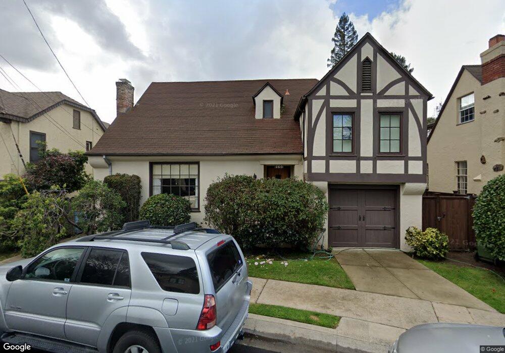
160 Brookside Dr Berkeley, CA 94705
Elmwood NeighborhoodEstimated Value: $1,809,511 - $2,444,000
4
Beds
1
Bath
1,999
Sq Ft
$1,109/Sq Ft
Est. Value
About This Home
This home is located at 160 Brookside Dr, Berkeley, CA 94705 and is currently estimated at $2,216,628, approximately $1,108 per square foot. 160 Brookside Dr is a home located in Alameda County with nearby schools including John Muir Elementary School, Emerson Elementary School, and Malcolm X Elementary School.
Ownership History
Date
Name
Owned For
Owner Type
Purchase Details
Closed on
Feb 9, 2021
Sold by
Baack Family Property Trust and Baack James H
Bought by
Baack Family Property Trust and Baack
Current Estimated Value
Purchase Details
Closed on
Jan 25, 2021
Sold by
Baack James H and Baack Sally A
Bought by
Baack James H and Baack Family Property Trust
Purchase Details
Closed on
Nov 20, 2002
Sold by
Baack Lawrence J and Baack Jane E
Bought by
Baack Lawrence J and Baack Jane F
Create a Home Valuation Report for This Property
The Home Valuation Report is an in-depth analysis detailing your home's value as well as a comparison with similar homes in the area
Home Values in the Area
Average Home Value in this Area
Purchase History
| Date | Buyer | Sale Price | Title Company |
|---|---|---|---|
| Baack Family Property Trust | -- | None Listed On Document | |
| Baack Family Property Trust | -- | None Listed On Document | |
| Baack James H | -- | None Available | |
| Baack James H | -- | None Available | |
| Baack Lawrence J | -- | None Available | |
| Baack Lawrence J | -- | -- |
Source: Public Records
Tax History
| Year | Tax Paid | Tax Assessment Tax Assessment Total Assessment is a certain percentage of the fair market value that is determined by local assessors to be the total taxable value of land and additions on the property. | Land | Improvement |
|---|---|---|---|---|
| 2025 | $6,660 | $328,737 | $211,559 | $117,178 |
| 2024 | $6,660 | $322,291 | $207,411 | $114,880 |
| 2023 | $6,505 | $315,972 | $203,344 | $112,628 |
| 2022 | $6,266 | $309,778 | $199,358 | $110,420 |
| 2021 | $6,252 | $296,704 | $195,449 | $108,255 |
| 2020 | $5,827 | $300,592 | $193,446 | $107,146 |
| 2019 | $5,498 | $294,699 | $189,654 | $105,045 |
| 2018 | $5,382 | $288,922 | $185,936 | $102,986 |
| 2017 | $5,167 | $283,257 | $182,290 | $100,967 |
| 2016 | $4,931 | $277,703 | $178,716 | $98,987 |
| 2015 | $4,854 | $273,532 | $176,032 | $97,500 |
| 2014 | $6,124 | $268,176 | $172,585 | $95,591 |
Source: Public Records
Map
Nearby Homes
- 2962 Piedmont Ave
- 2477 Prince St
- 360 Alcatraz Ave
- 6446 Colby St
- 6100 Chabot Rd
- 2817 Palm Ct
- 2935 Florence St
- 2643 Stuart St
- 204 El Camino Real
- 6189 Margarido Dr
- 5941 Keith Ave
- 2917 Telegraph Ave
- 5936 Broadway
- 6445 Irwin Ct
- 1488 Alvarado Rd
- 2632 Warring St Unit 3
- 2243 Ashby Ave
- 3046 Deakin St
- 641 Alvarado Rd
- 190 Stonewall Rd
- 158 Brookside Dr
- 170 Brookside Dr
- 3131 Eton Ave
- 180 Brookside Dr
- 156 Brookside Dr
- 3127 Eton Ave
- 151 Brookside Dr
- 3135 Eton Ave
- 171 Brookside Dr
- 3123 Eton Ave
- 3139 Eton Ave
- 190 Brookside Dr
- 150 Brookside Dr
- 152 Brookside Dr
- 3130 Claremont Ave
- 181 Brookside Dr
- 3119 Eton Ave
- 121 Brookside Dr
- 154 Brookside Dr
- 3143 Eton Ave
Your Personal Tour Guide
Ask me questions while you tour the home.