A
Seller's Agent in 2018
Aaron Lamb
Engel & Voelkers Bend
(541) 508-8698
51 Total Sales

Estimated Value: $33,792
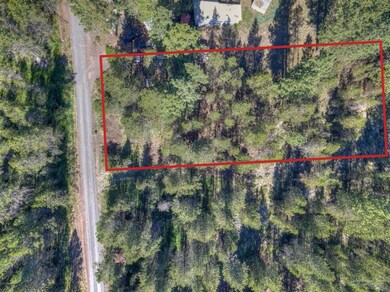
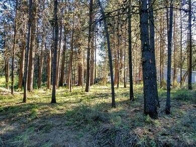
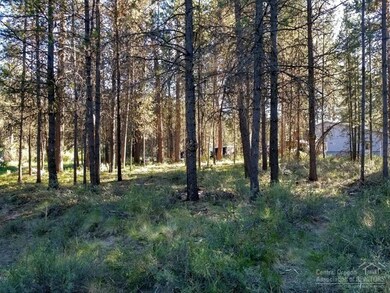
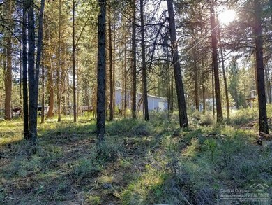
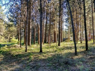
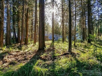
Potential Buildable Private half acre lot in a Deschutes River access community. Great location in the heart of Central Oregon w boat ramps on the Deschutes River. Near US Forest lands, Cascade Lakes, Mt Bachelor, Sunriver, La Pine State Park & all things outdoors. Central Oregon Land is HOT, don't wait on this one! Reduced Price and Land was just professionally cleared of brush & thinned for potential build.
Last Agent to Sell the Property
Engel & Voelkers Bend License #201009126 Listed on: 04/04/2018

Co-Listed By
Jim Birtola
Team Birtola High Desert License #960600032
Property Type
Est. Annual Taxes
Lot Details
Property Views
Schools
Community Details
Listing and Financial Details
| Date | Buyer | Sale Price | Title Company |
|---|---|---|---|
| Sanna John F | $17,500 | First American Title | |
| Schneyder Kyla M | $1,000 | Western Title & Escrow Co |
| Date | Status | Borrower | Loan Amount |
|---|---|---|---|
| Closed | Sanna John F | $0 |
| Date | Event | Price | Change | Sq Ft Price |
|---|---|---|---|---|
| 09/11/2018 09/11/18 | Sold | $17,500 | -50.0% | -- |
| 08/22/2018 08/22/18 | Pending | -- | -- | -- |
| 04/04/2018 04/04/18 | For Sale | $35,000 | -- | -- |
| Year | Tax Paid | Tax Assessment Tax Assessment Total Assessment is a certain percentage of the fair market value that is determined by local assessors to be the total taxable value of land and additions on the property. | Land | Improvement |
|---|---|---|---|---|
| 2024 | $133 | $7,900 | $7,900 | -- |
| 2023 | $131 | $7,670 | $7,670 | $0 |
| 2022 | $122 | $7,240 | $0 | $0 |
| 2021 | $123 | $7,030 | $0 | $0 |
| 2020 | $117 | $7,030 | $0 | $0 |
| 2019 | $114 | $6,830 | $0 | $0 |
| 2018 | $112 | $6,640 | $0 | $0 |
| 2017 | $109 | $6,450 | $0 | $0 |
| 2016 | $105 | $6,270 | $0 | $0 |
| 2015 | $103 | $6,090 | $0 | $0 |
| 2014 | $100 | $5,920 | $0 | $0 |
A
Seller's Agent in 2018
Aaron Lamb
Engel & Voelkers Bend
(541) 508-8698
51 Total Sales
J
Seller Co-Listing Agent in 2018
Jim Birtola
Team Birtola High Desert
G
Buyer's Agent in 2018
Gail Ballantyne
Sunriver Realty
(541) 480-7081
30 Total Sales
Source: Oregon Datashare
MLS Number: 201803046
APN: 126769
Disclaimer: Certain information contained herein is derived from information provided by parties other than Homes.com. All information provided is deemed reliable, but is not guaranteed to be accurate and should be independently verified.
![]() © 2025 Oregon Datashare (KCAR | MLSCO | SOMLS). All rights reserved. The data relating to real estate for sale on this web site comes in part from the Internet Data Exchange Program of the Oregon Datashare. Real estate listings held by IDX Brokerage firms other than Ten-X are marked with the Internet Data Exchange logo or the Internet Data Exchange thumbnail logo and detailed information about them includes the name of the listing Brokers. Information provided is for consumers' personal, non-commercial use and may not be used for any purpose other than to identify prospective properties the viewer may be interested in purchasing. The consumer will not copy, retransmit nor redistribute any of the content from this website. Information provided is deemed reliable, but not guaranteed.
© 2025 Oregon Datashare (KCAR | MLSCO | SOMLS). All rights reserved. The data relating to real estate for sale on this web site comes in part from the Internet Data Exchange Program of the Oregon Datashare. Real estate listings held by IDX Brokerage firms other than Ten-X are marked with the Internet Data Exchange logo or the Internet Data Exchange thumbnail logo and detailed information about them includes the name of the listing Brokers. Information provided is for consumers' personal, non-commercial use and may not be used for any purpose other than to identify prospective properties the viewer may be interested in purchasing. The consumer will not copy, retransmit nor redistribute any of the content from this website. Information provided is deemed reliable, but not guaranteed.