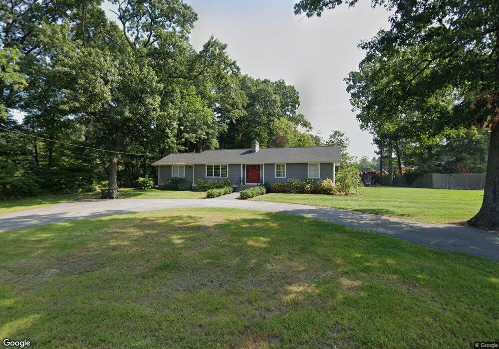
164 Maple St Bellingham, MA 02019
Estimated Value: $543,173 - $581,000
3
Beds
2
Baths
1,936
Sq Ft
$290/Sq Ft
Est. Value
About This Home
This home is located at 164 Maple St, Bellingham, MA 02019 and is currently estimated at $561,293, approximately $289 per square foot. 164 Maple St is a home located in Norfolk County with nearby schools including Stall Brook Elementary School, Bellingham High School, and Bethany Christian Academy.
Ownership History
Date
Name
Owned For
Owner Type
Purchase Details
Closed on
Aug 10, 2010
Sold by
Vollmuth Gary R and Vollmuth Denis C
Bought by
Cobb Jeanine A
Current Estimated Value
Home Financials for this Owner
Home Financials are based on the most recent Mortgage that was taken out on this home.
Original Mortgage
$180,000
Outstanding Balance
$120,135
Interest Rate
4.73%
Mortgage Type
Purchase Money Mortgage
Estimated Equity
$441,158
Purchase Details
Closed on
Oct 14, 2005
Sold by
Weed Richard J
Bought by
Vollmuth Denis C and Vollmuth Gary R
Home Financials for this Owner
Home Financials are based on the most recent Mortgage that was taken out on this home.
Original Mortgage
$328,500
Interest Rate
5.78%
Mortgage Type
Purchase Money Mortgage
Create a Home Valuation Report for This Property
The Home Valuation Report is an in-depth analysis detailing your home's value as well as a comparison with similar homes in the area
Home Values in the Area
Average Home Value in this Area
Purchase History
| Date | Buyer | Sale Price | Title Company |
|---|---|---|---|
| Cobb Jeanine A | $240,000 | -- | |
| Vollmuth Denis C | $365,000 | -- |
Source: Public Records
Mortgage History
| Date | Status | Borrower | Loan Amount |
|---|---|---|---|
| Open | Cobb Jeanine A | $180,000 | |
| Previous Owner | Vollmuth Denis C | $328,500 |
Source: Public Records
Tax History
| Year | Tax Paid | Tax Assessment Tax Assessment Total Assessment is a certain percentage of the fair market value that is determined by local assessors to be the total taxable value of land and additions on the property. | Land | Improvement |
|---|---|---|---|---|
| 2025 | $5,174 | $411,925 | $132,600 | $279,325 |
| 2024 | $4,960 | $385,700 | $121,100 | $264,600 |
| 2023 | $4,779 | $366,220 | $115,300 | $250,920 |
| 2022 | $4,689 | $333,055 | $96,200 | $236,855 |
| 2021 | $4,395 | $305,030 | $96,200 | $208,830 |
| 2020 | $4,204 | $295,620 | $96,200 | $199,420 |
| 2019 | $4,098 | $288,400 | $96,200 | $192,200 |
| 2018 | $3,896 | $270,390 | $97,000 | $173,390 |
| 2017 | $3,531 | $246,260 | $97,000 | $149,260 |
| 2016 | $3,438 | $240,565 | $100,900 | $139,665 |
| 2015 | $3,297 | $231,345 | $97,000 | $134,345 |
| 2014 | $3,279 | $223,670 | $93,600 | $130,070 |
Source: Public Records
Map
Nearby Homes
- 17 Pine St
- 60 Pine St
- 44 Arapahoe Rd
- 214 Conlyn Ave
- 276 Pond St
- 201 Crossfield Rd
- 38 Conlyn Ave
- 8 Riverstone Way
- 18 Mary Anne Dr
- 25 Brookview Rd
- 462 Hartford Ave
- 834-836 W Central St
- 0 Hixon St Unit 73477486
- 110 Lisa Ann Dr
- 67 Jeannine Rd
- 48 Donna Rd
- 7 Palmetto Dr Unit 7
- 1801 Franklin Crossing Rd Unit 1801
- 2211 Franklin Crossing Rd Unit 2211
- 60 Wethersfield Rd
Your Personal Tour Guide
Ask me questions while you tour the home.