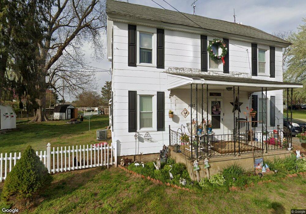
1642 Cypress Branch Rd Dover, DE 19901
Rising Sun-Lebanon NeighborhoodEstimated Value: $283,000 - $336,000
2
Beds
2
Baths
1,752
Sq Ft
$177/Sq Ft
Est. Value
About This Home
This home is located at 1642 Cypress Branch Rd, Dover, DE 19901 and is currently estimated at $310,266, approximately $177 per square foot. 1642 Cypress Branch Rd is a home located in Kent County with nearby schools including Allen Frear Elementary School, F. Niel Postlethwait Middle School, and Caesar Rodney High School.
Ownership History
Date
Name
Owned For
Owner Type
Purchase Details
Closed on
Feb 9, 2011
Sold by
Hsbc Bank Usa National Association
Bought by
Coombes Margaret
Current Estimated Value
Purchase Details
Closed on
Nov 15, 2010
Sold by
Foster Adam and Hutchins Heather
Bought by
Hsbc Bank Usa National Association
Create a Home Valuation Report for This Property
The Home Valuation Report is an in-depth analysis detailing your home's value as well as a comparison with similar homes in the area
Home Values in the Area
Average Home Value in this Area
Purchase History
| Date | Buyer | Sale Price | Title Company |
|---|---|---|---|
| Coombes Margaret | $18,500 | None Available | |
| Hsbc Bank Usa National Association | $118,465 | None Available |
Source: Public Records
Tax History Compared to Growth
Tax History
| Year | Tax Paid | Tax Assessment Tax Assessment Total Assessment is a certain percentage of the fair market value that is determined by local assessors to be the total taxable value of land and additions on the property. | Land | Improvement |
|---|---|---|---|---|
| 2025 | $957 | $239,200 | $89,100 | $150,100 |
| 2024 | $957 | $239,200 | $89,100 | $150,100 |
| 2023 | $578 | $22,400 | $4,800 | $17,600 |
| 2022 | $546 | $22,400 | $4,800 | $17,600 |
| 2021 | $542 | $22,400 | $4,800 | $17,600 |
| 2020 | $533 | $22,400 | $4,800 | $17,600 |
| 2019 | $512 | $22,400 | $4,800 | $17,600 |
| 2018 | $494 | $22,400 | $4,800 | $17,600 |
| 2017 | $480 | $22,400 | $0 | $0 |
| 2016 | $470 | $22,400 | $0 | $0 |
| 2015 | $395 | $22,400 | $0 | $0 |
| 2014 | $394 | $22,400 | $0 | $0 |
Source: Public Records
Map
Nearby Homes
- 38 Planters Run Ct
- 580 Locust Grove Rd
- 128 Jillian Ct
- 1810 Windswept Cir
- 5 Crossley Dr
- 2043 Highland Ave
- 83 Homestead Dr
- 207 Chenault Ct
- 3444 S State St
- 200 Beechwood Ave Unit 2
- 106 Steffens Blvd
- 1694 S State St
- 1679 S State St Unit A55
- 123 Candlewick Dr
- 282 Beechwood Ave
- 276 Beechwood Ave
- 326 Remington Dr
- 100 S Shore Dr
- 279 Remington Dr
- 284 Remington Dr
- 1651 Cypress Branch Rd
- 1637 Cypress Branch Rd
- 1654 Cypress Branch Rd
- 1605 Cypress Branch Rd
- 1605 Cypress Branch Rd Unit 1
- 1656 Cypress Branch Rd
- 1614 Cypress Branch Rd
- 1650 Cypress Branch Rd
- 1168 Sorghum Mill Rd
- 1184 Sorghum Mill Rd
- 1627 Cypress Branch Rd
- 1163 Sorghum Mill Rd
- 1196 Sorghum Mill Rd
- 1605 Cypress Branch Rd
- 1121 Sorghum Mill Rd
- 1183 Sorghum Mill Rd
- 1105 Sorghum Mill Rd
- 1101 Sorghum Mill Rd
- 1101 Sorghum Mill Rd
- 1195 Sorghum Mill Rd