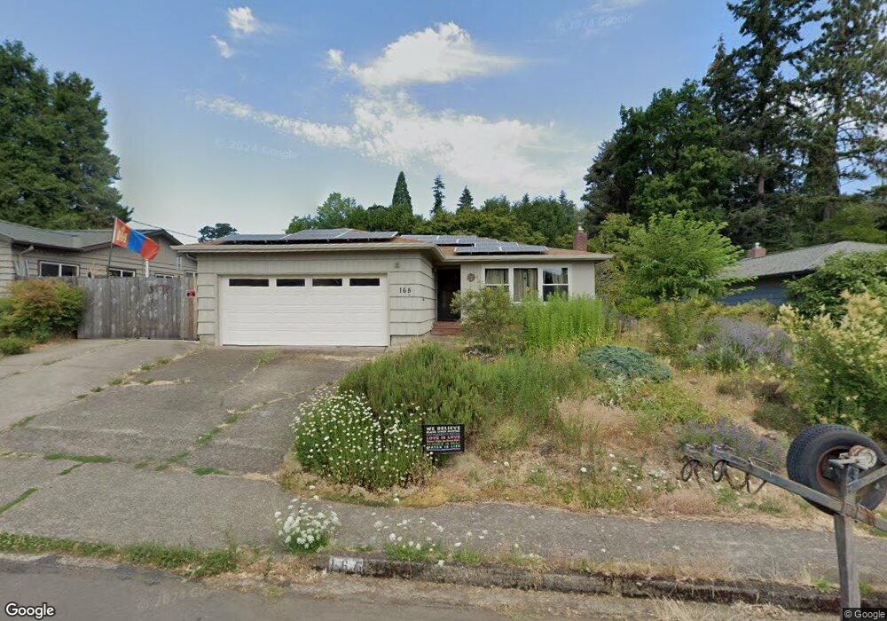
165 E 39th Ave Eugene, OR 97405
Southeast Eugene NeighborhoodEstimated Value: $427,000 - $541,000
3
Beds
2
Baths
1,239
Sq Ft
$394/Sq Ft
Est. Value
About This Home
This home is located at 165 E 39th Ave, Eugene, OR 97405 and is currently estimated at $488,499, approximately $394 per square foot. 165 E 39th Ave is a home located in Lane County with nearby schools including Camas Ridge Community Elementary School, Spencer Butte Middle School, and South Eugene High School.
Ownership History
Date
Name
Owned For
Owner Type
Purchase Details
Closed on
May 1, 2009
Sold by
Longo Stefano and Longo Jeannette
Bought by
Code Aimee B and Ramsey Matthew C
Current Estimated Value
Home Financials for this Owner
Home Financials are based on the most recent Mortgage that was taken out on this home.
Original Mortgage
$132,750
Outstanding Balance
$83,782
Interest Rate
4.99%
Mortgage Type
Purchase Money Mortgage
Estimated Equity
$404,717
Purchase Details
Closed on
Jun 5, 2003
Sold by
Britton James
Bought by
Longo Stefano and Longo Jeannette
Home Financials for this Owner
Home Financials are based on the most recent Mortgage that was taken out on this home.
Original Mortgage
$100,000
Interest Rate
5.61%
Mortgage Type
Purchase Money Mortgage
Create a Home Valuation Report for This Property
The Home Valuation Report is an in-depth analysis detailing your home's value as well as a comparison with similar homes in the area
Home Values in the Area
Average Home Value in this Area
Purchase History
| Date | Buyer | Sale Price | Title Company |
|---|---|---|---|
| Code Aimee B | $271,000 | Western Title | |
| Longo Stefano | $160,500 | Western Title & Escrow Compa |
Source: Public Records
Mortgage History
| Date | Status | Borrower | Loan Amount |
|---|---|---|---|
| Open | Code Aimee B | $132,750 | |
| Previous Owner | Longo Stefano | $100,000 |
Source: Public Records
Tax History
| Year | Tax Paid | Tax Assessment Tax Assessment Total Assessment is a certain percentage of the fair market value that is determined by local assessors to be the total taxable value of land and additions on the property. | Land | Improvement |
|---|---|---|---|---|
| 2025 | $4,079 | $209,347 | -- | -- |
| 2024 | $4,028 | $203,250 | -- | -- |
| 2023 | $4,028 | $197,331 | -- | -- |
| 2022 | $3,774 | $191,584 | $0 | $0 |
| 2021 | $3,544 | $186,004 | $0 | $0 |
| 2020 | $3,557 | $180,587 | $0 | $0 |
| 2019 | $3,435 | $175,328 | $0 | $0 |
| 2018 | $3,234 | $165,264 | $0 | $0 |
| 2017 | $3,089 | $165,264 | $0 | $0 |
| 2016 | $3,012 | $160,450 | $0 | $0 |
| 2015 | $2,926 | $155,777 | $0 | $0 |
| 2014 | $2,867 | $151,240 | $0 | $0 |
Source: Public Records
Map
Nearby Homes
- 275 E 39th Ave
- 170 E 40th Ave
- 4020 Pearl St
- 434 E 39th Ave
- 3615 Donald St
- 4023 Donald St Unit K
- 4083 Donald St Unit A
- 0 E 39th Ave
- 3855 Ferry St
- 3820 Watkins Ln
- 4315 High St
- 275 W 37th Ave
- 357 W 37th Ave
- 810 E 37th Ave
- 4103 Brae Burn Dr
- 17 Westbrook Way
- 21 Westbrook Way
- 478 E 32nd Ave
- 660 E 32nd Ave
- 4495 Pinecrest Dr