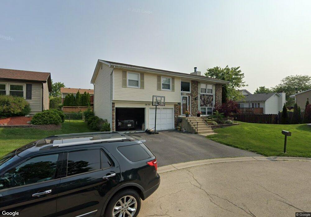
1670 Cape Breton Ct Hoffman Estates, IL 60192
South Ridge NeighborhoodEstimated Value: $401,000 - $429,000
3
Beds
1
Bath
1,176
Sq Ft
$350/Sq Ft
Est. Value
About This Home
This home is located at 1670 Cape Breton Ct, Hoffman Estates, IL 60192 and is currently estimated at $411,727, approximately $350 per square foot. 1670 Cape Breton Ct is a home located in Cook County with nearby schools including Thomas Jefferson Elementary School, Frank C. Whiteley Elementary School, and Plum Grove Jr High School.
Ownership History
Date
Name
Owned For
Owner Type
Purchase Details
Closed on
May 28, 1998
Sold by
Litkowiak Stephen J and Litkowiak Katherine D
Bought by
Frost Gregory R
Current Estimated Value
Home Financials for this Owner
Home Financials are based on the most recent Mortgage that was taken out on this home.
Original Mortgage
$140,000
Outstanding Balance
$28,545
Interest Rate
7.27%
Estimated Equity
$383,182
Create a Home Valuation Report for This Property
The Home Valuation Report is an in-depth analysis detailing your home's value as well as a comparison with similar homes in the area
Home Values in the Area
Average Home Value in this Area
Purchase History
| Date | Buyer | Sale Price | Title Company |
|---|---|---|---|
| Frost Gregory R | $157,000 | -- |
Source: Public Records
Mortgage History
| Date | Status | Borrower | Loan Amount |
|---|---|---|---|
| Open | Frost Gregory R | $140,000 |
Source: Public Records
Tax History Compared to Growth
Tax History
| Year | Tax Paid | Tax Assessment Tax Assessment Total Assessment is a certain percentage of the fair market value that is determined by local assessors to be the total taxable value of land and additions on the property. | Land | Improvement |
|---|---|---|---|---|
| 2024 | $8,487 | $31,001 | $4,811 | $26,190 |
| 2023 | $8,172 | $31,001 | $4,811 | $26,190 |
| 2022 | $8,172 | $31,001 | $4,811 | $26,190 |
| 2021 | $7,143 | $24,662 | $3,340 | $21,322 |
| 2020 | $7,061 | $24,662 | $3,340 | $21,322 |
| 2019 | $6,989 | $27,342 | $3,340 | $24,002 |
| 2018 | $7,336 | $26,591 | $3,073 | $23,518 |
| 2017 | $7,218 | $26,591 | $3,073 | $23,518 |
| 2016 | $6,953 | $26,591 | $3,073 | $23,518 |
| 2015 | $6,403 | $23,224 | $2,806 | $20,418 |
| 2014 | $6,299 | $23,224 | $2,806 | $20,418 |
| 2013 | $6,121 | $23,224 | $2,806 | $20,418 |
Source: Public Records
Map
Nearby Homes
- 13 Chipping Campden Dr
- 1404 W Sapphire Dr
- 4760 Amber Cir
- 4564 Topaz Dr
- 26 Forest Ln
- 39 Forest Ln
- 16 Forest Ln
- 4000 Huntington Blvd
- 4827 Turnberry Dr
- 61 E Palatine Rd
- 61 E Rd
- 61 E Rd
- 61 E Palatine #4 Rd
- 4890 Prestwick Place
- 4950 Rochester Dr
- 1208 Old Timber Ln
- 1195 Old Timber Ct
- 4944 Somerton Dr
- 5015 Rochester Dr
- 3835 Huntington Blvd
- 1680 Cape Breton Ct
- 4500 Bicek Ct
- 1669 Dover Ct
- 1660 Cape Breton Ct
- 4510 Bicek Ct
- 1679 Dover Ct
- 4490 Bicek Ct
- 1690 Cape Breton Ct
- 1659 Cape Breton Ct
- 1659 Dover Ct
- 1689 Dover Ct
- 1689 Cape Breton Ct
- 1669 Cape Breton Ct
- 4491 Bicek Ct
- 4520 Bicek Ct
- 1679 Cape Breton Ct
- 4491 Bayside Cir Unit 4
- 4469 Huntington Blvd
- 4485 Bayside Cir
- 1660 Dover Ct