Estimated Value: $685,000 - $859,000
3
Beds
2
Baths
1,638
Sq Ft
$487/Sq Ft
Est. Value
About This Home
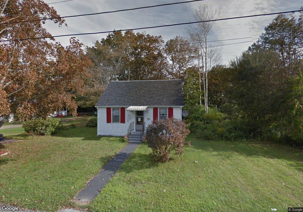
This home is located at 17 Oceanside Ave, York, ME 03909 and is currently estimated at $797,357, approximately $486 per square foot. 17 Oceanside Ave is a home located in York County with nearby schools including Coastal Ridge Elementary School, Village Elementary School, and York Middle School.
Ownership History
Date
Name
Owned For
Owner Type
Purchase Details
Closed on
Sep 22, 2016
Sold by
Amaral Shirley and Amaral Scott
Bought by
Ir Shirley and Ir Paul
Current Estimated Value
Purchase Details
Closed on
Jun 17, 2016
Sold by
Amaral Shirley
Bought by
Amaral Shirley and Amaral Paul
Purchase Details
Closed on
Jul 1, 2005
Sold by
Davis Clarice Est and Robinson
Bought by
Amaral Shirley
Create a Home Valuation Report for This Property
The Home Valuation Report is an in-depth analysis detailing your home's value as well as a comparison with similar homes in the area
Home Values in the Area
Average Home Value in this Area
Purchase History
| Date | Buyer | Sale Price | Title Company |
|---|---|---|---|
| Ir Shirley | -- | -- | |
| Shirley | -- | -- | |
| Shirley | -- | -- | |
| Amaral Shirley | -- | -- | |
| Amaral Shirley | -- | -- | |
| Amaral Shirley | -- | -- | |
| Amaral Shirley | -- | -- |
Source: Public Records
Mortgage History
| Date | Status | Borrower | Loan Amount |
|---|---|---|---|
| Open | Amaral Shirley | $80,000 | |
| Open | Amaral Shirley | $295,000 |
Source: Public Records
Tax History
| Year | Tax Paid | Tax Assessment Tax Assessment Total Assessment is a certain percentage of the fair market value that is determined by local assessors to be the total taxable value of land and additions on the property. | Land | Improvement |
|---|---|---|---|---|
| 2024 | $5,530 | $658,300 | $343,300 | $315,000 |
| 2023 | $5,598 | $662,500 | $347,500 | $315,000 |
| 2022 | $5,058 | $591,600 | $347,500 | $244,100 |
| 2021 | $5,284 | $531,100 | $324,300 | $206,800 |
| 2020 | $4,988 | $449,400 | $305,800 | $143,600 |
| 2019 | $4,974 | $446,100 | $305,800 | $140,300 |
| 2018 | $2,514 | $446,100 | $305,800 | $140,300 |
| 2017 | $5,350 | $488,600 | $296,500 | $192,100 |
| 2016 | $5,534 | $496,300 | $296,500 | $199,800 |
| 2015 | $5,165 | $469,500 | $296,500 | $173,000 |
| 2014 | $5,024 | $469,500 | $296,500 | $173,000 |
| 2013 | $4,897 | $469,500 | $296,500 | $173,000 |
Source: Public Records
Map
Nearby Homes
- 8 Oceanside Ave Unit 2
- 115 Long Beach Ave Unit 3
- Lot A Juniper Rd
- 8 Jeremiah Ln
- 10 Yorke Ridge Way
- 31 Beacon Street Extension
- 24 Spring Pond Cir
- 12 Cardinal Ln
- 35 Gunnison Rd
- 293 Long Beach Ave
- 11 Driftwood Ln
- 6 Dingle Rd Unit 4
- 6 Dingle Rd Unit 5
- 5 Mckenna Ln
- 81 Nubble Rd
- 15 Summer Breeze Unit A & B
- 1 Ocean Ave Unit 211/213 Fraction 1
- 1 Ocean Ave Unit 414 Fraction 6
- 1 Ocean Ave Unit 210/212 Fraction 3
- 1 Ocean Ave Unit 307 Fraction 3
Your Personal Tour Guide
Ask me questions while you tour the home.