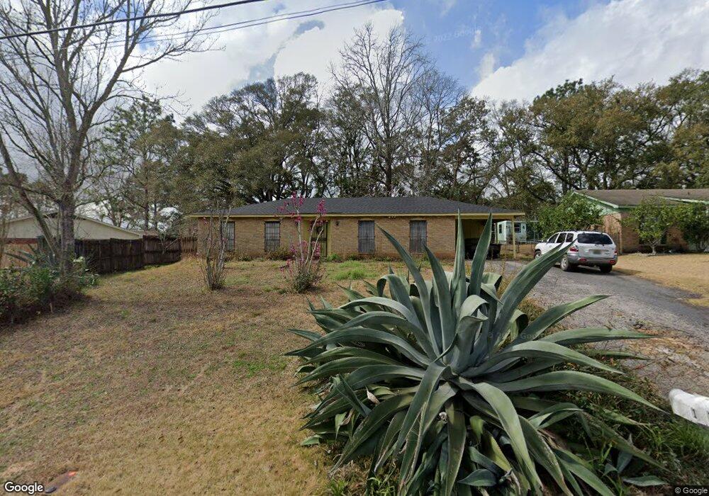
1712 Andover Blvd Mobile, AL 36609
Malibar Heights NeighborhoodEstimated Value: $127,245 - $193,000
--
Bed
2
Baths
1,458
Sq Ft
$104/Sq Ft
Est. Value
About This Home
This home is located at 1712 Andover Blvd, Mobile, AL 36609 and is currently estimated at $151,561, approximately $103 per square foot. 1712 Andover Blvd is a home located in Mobile County with nearby schools including Olive J. Dodge Elementary School, Burns Middle School, and WP Davidson High School.
Ownership History
Date
Name
Owned For
Owner Type
Purchase Details
Closed on
Jul 15, 2022
Sold by
Glenn Flanagan Sr
Bought by
Flanagan Ralph
Current Estimated Value
Purchase Details
Closed on
Dec 11, 2012
Sold by
Flanagan Samuel Lee and Flanagan Glen
Bought by
Flanagan Samuel Lee and Flanagan Glenn
Purchase Details
Closed on
Oct 9, 2010
Sold by
Flanagan Ralph
Bought by
Flanagan Samuel L
Purchase Details
Closed on
Apr 15, 2004
Sold by
Flanagan Samuel Lee
Bought by
Flanagan Samuel Lee and Flanagan Glenn
Purchase Details
Closed on
Apr 24, 2002
Sold by
Homeside Lending Inc
Bought by
Hud
Purchase Details
Closed on
Mar 8, 2002
Sold by
Guthrie Lorin T and Guthrie Amy
Bought by
Homeside Lending Inc
Create a Home Valuation Report for This Property
The Home Valuation Report is an in-depth analysis detailing your home's value as well as a comparison with similar homes in the area
Home Values in the Area
Average Home Value in this Area
Purchase History
| Date | Buyer | Sale Price | Title Company |
|---|---|---|---|
| Flanagan Ralph | $92,400 | None Listed On Document | |
| Flanagan Samuel Lee | $31,967 | None Available | |
| Flanagan Samuel L | -- | None Available | |
| Flanagan Samuel Lee | -- | -- | |
| Hud | -- | -- | |
| Homeside Lending Inc | $68,196 | -- |
Source: Public Records
Tax History Compared to Growth
Tax History
| Year | Tax Paid | Tax Assessment Tax Assessment Total Assessment is a certain percentage of the fair market value that is determined by local assessors to be the total taxable value of land and additions on the property. | Land | Improvement |
|---|---|---|---|---|
| 2024 | $1,364 | $10,660 | $2,000 | $8,660 |
| 2023 | $1,364 | $9,800 | $1,950 | $7,850 |
| 2022 | $555 | $9,240 | $1,800 | $7,440 |
| 2021 | $0 | $8,460 | $1,500 | $6,960 |
| 2020 | $359 | $8,470 | $1,500 | $6,970 |
| 2019 | $426 | $8,280 | $1,500 | $6,780 |
| 2018 | $404 | $7,940 | $0 | $0 |
| 2017 | $480 | $9,180 | $0 | $0 |
| 2016 | $390 | $7,720 | $0 | $0 |
| 2013 | $580 | $9,600 | $0 | $0 |
Source: Public Records
Map
Nearby Homes
- 1609 Oak Forest Ct
- 5409 Cortez Dr
- 1508 Oak Cliff Ct
- 4458 Wolf Creek Dr N
- 708 Monarch Dr W
- 5552 Fairfield Place
- 5621 Vista Bonita Dr S
- 5305 Oak Bend Ct
- 1429 Regency Oaks Dr E
- 1712 Rustic Wood Ct
- 5738 Green Tree Rd
- 4303 Panorama Blvd
- 1933 Wildwood Place
- 5833 Water Oak Ct
- 1833 Spring Brook Ct
- 4300 David St
- 1028 Oakland Dr
- 5805 Holly Hill Ct
- 4259 Raines Dr
- 2120 Panorama Dr
- 1708 Andover Blvd
- 1716 Andover Blvd
- 1745 Snowmass Ct
- 1749 Snowmass Ct
- 1741 Snowmass Ct
- 1753 Snowmass Ct
- 1704 Andover Blvd
- 1737 Snowmass Ct
- 1757 Snowmass Ct
- 1733 Snowmass Ct
- 1717 Andover Blvd
- 1729 Snowmass Ct
- 1713 Andover Blvd
- 1700 Andover Blvd
- 1725 Snowmass Ct
- 1709 Andover Blvd
- 5605 Acampo Blvd
- 1721 Snowmass Ct
- 1705 Andover Blvd
- 5601 Acampo Blvd