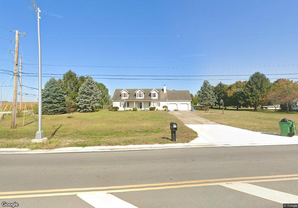
1780 E Possum Rd Springfield, OH 45502
Estimated Value: $374,795 - $431,000
4
Beds
3
Baths
2,778
Sq Ft
$145/Sq Ft
Est. Value
About This Home
This home is located at 1780 E Possum Rd, Springfield, OH 45502 and is currently estimated at $403,699, approximately $145 per square foot. 1780 E Possum Rd is a home located in Clark County with nearby schools including Possum Elementary School, Shawnee Middle School/High School, and Springfield Preparatory & Fitness Academy.
Ownership History
Date
Name
Owned For
Owner Type
Purchase Details
Closed on
Jul 25, 2006
Sold by
Martino John L and Martino Tonia K
Bought by
Smith Gregory T and Smith Teresa
Current Estimated Value
Home Financials for this Owner
Home Financials are based on the most recent Mortgage that was taken out on this home.
Original Mortgage
$213,000
Interest Rate
8.75%
Mortgage Type
Balloon
Purchase Details
Closed on
Jul 30, 1993
Sold by
Martin Donald T and Ann Sally
Bought by
Martino John L and Martino Tonia K
Purchase Details
Closed on
Jan 9, 1992
Create a Home Valuation Report for This Property
The Home Valuation Report is an in-depth analysis detailing your home's value as well as a comparison with similar homes in the area
Purchase History
| Date | Buyer | Sale Price | Title Company |
|---|---|---|---|
| Smith Gregory T | $213,000 | None Available | |
| Martino John L | $146,000 | -- | |
| -- | $20,000 | -- |
Source: Public Records
Mortgage History
| Date | Status | Borrower | Loan Amount |
|---|---|---|---|
| Previous Owner | Smith Gregory T | $213,000 |
Source: Public Records
Tax History
| Year | Tax Paid | Tax Assessment Tax Assessment Total Assessment is a certain percentage of the fair market value that is determined by local assessors to be the total taxable value of land and additions on the property. | Land | Improvement |
|---|---|---|---|---|
| 2025 | $4,561 | $97,750 | $16,590 | $81,160 |
| 2024 | $4,443 | $90,940 | $13,250 | $77,690 |
| 2023 | $4,443 | $90,940 | $13,250 | $77,690 |
| 2022 | $4,406 | $90,940 | $13,250 | $77,690 |
| 2021 | $3,816 | $70,510 | $10,280 | $60,230 |
| 2020 | $3,847 | $70,510 | $10,280 | $60,230 |
| 2019 | $3,908 | $70,510 | $10,280 | $60,230 |
| 2018 | $3,532 | $62,870 | $9,340 | $53,530 |
| 2017 | $3,620 | $62,871 | $9,342 | $53,529 |
| 2016 | $3,266 | $62,871 | $9,342 | $53,529 |
| 2015 | $3,267 | $60,789 | $9,342 | $51,447 |
| 2014 | $3,276 | $60,789 | $9,342 | $51,447 |
| 2013 | $2,846 | $60,789 | $9,342 | $51,447 |
Source: Public Records
Map
Nearby Homes
- 2390 Old Selma Rd
- 2215 Hackberry St
- 2214 Hackberry St
- 2211 Hackberry St
- 2210 Hackberry St
- 2207 Hackberry St
- 2208 Hackberry St
- 2209 Hackberry St
- 4975 Selma Pike
- 4716 Old Clifton Rd
- 2224 Cheviot Hills Dr
- 533 Highview Ave
- 711 Kinnane Ave
- 2076-2078 Stowe Dr
- 2037 Gerald Dr
- 533 Lyle Ave
- 3016 Old Springfield Rd
- 201 Kinnane Ave
- 1835 S Sweetbriar Ln
- 1630 S Sweetbriar Ln
- 1800 E Possum Rd
- 3460 Selma Rd
- 1810 E Possum Rd
- 3434 Selma Rd
- 3434 Selma Pike
- 1820 E Possum Rd
- 3435 Kenerly St
- 3420 Selma Rd
- 3405 Kenerly St
- 3475 Kenerly St
- 3375 Kenerly St
- 3350 Selma Rd
- 3345 Kenerly St
- 3490 Kenerly St
- 3460 Kenerly St
- 3400 Kenerly St
- 3430 Kenerly St
- 3370 Kenerly St
- 3340 Kenerly St
- 3766 Selma Rd
Your Personal Tour Guide
Ask me questions while you tour the home.