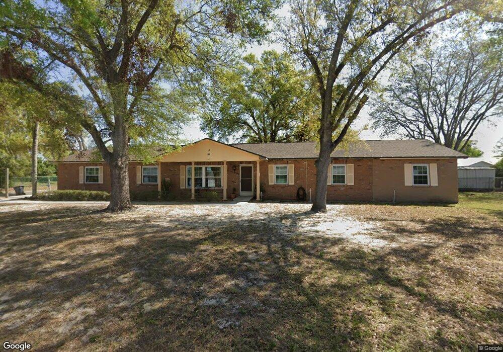
1801 Lido Dr Brandon, FL 33511
Estimated Value: $445,746 - $508,000
5
Beds
3
Baths
2,578
Sq Ft
$187/Sq Ft
Est. Value
About This Home
This home is located at 1801 Lido Dr, Brandon, FL 33511 and is currently estimated at $483,187, approximately $187 per square foot. 1801 Lido Dr is a home located in Hillsborough County with nearby schools including Brooker Elementary School, Burns Middle School, and Bloomingdale High School.
Ownership History
Date
Name
Owned For
Owner Type
Purchase Details
Closed on
Nov 20, 2013
Sold by
Managad Juan and Managad Thelma
Bought by
Managad Family Management Llc
Current Estimated Value
Purchase Details
Closed on
Apr 4, 1997
Sold by
Chris M Mira Tr and Patricia L Mira Tr
Bought by
Managad Juan F and Managad Thelma L
Home Financials for this Owner
Home Financials are based on the most recent Mortgage that was taken out on this home.
Original Mortgage
$110,105
Interest Rate
7.58%
Mortgage Type
New Conventional
Create a Home Valuation Report for This Property
The Home Valuation Report is an in-depth analysis detailing your home's value as well as a comparison with similar homes in the area
Home Values in the Area
Average Home Value in this Area
Purchase History
| Date | Buyer | Sale Price | Title Company |
|---|---|---|---|
| Managad Family Management Llc | -- | None Available | |
| Managad Juan F | $115,900 | -- |
Source: Public Records
Mortgage History
| Date | Status | Borrower | Loan Amount |
|---|---|---|---|
| Previous Owner | Managad Juan F | $155,402 | |
| Previous Owner | Managad Juan F | $110,105 |
Source: Public Records
Tax History Compared to Growth
Tax History
| Year | Tax Paid | Tax Assessment Tax Assessment Total Assessment is a certain percentage of the fair market value that is determined by local assessors to be the total taxable value of land and additions on the property. | Land | Improvement |
|---|---|---|---|---|
| 2024 | $6,577 | $355,949 | $120,215 | $235,734 |
| 2023 | $6,205 | $358,592 | $110,968 | $247,624 |
| 2022 | $5,922 | $377,942 | $110,968 | $266,974 |
| 2021 | $5,110 | $269,443 | $92,473 | $176,970 |
| 2020 | $4,696 | $250,839 | $76,753 | $174,086 |
| 2019 | $4,378 | $241,600 | $64,731 | $176,869 |
| 2018 | $4,050 | $227,061 | $0 | $0 |
| 2017 | $3,659 | $193,122 | $0 | $0 |
| 2016 | $3,407 | $156,167 | $0 | $0 |
| 2015 | $3,194 | $141,970 | $0 | $0 |
| 2014 | $2,875 | $129,064 | $0 | $0 |
| 2013 | -- | $117,331 | $0 | $0 |
Source: Public Records
Map
Nearby Homes
- 123 Jeffrey Dr
- 1909 Lido Dr
- 1807 Green Lawn St
- 2204 Krista Ln
- 2518 Knight Island Dr
- 1726 Loriana St
- 2310 Medford Ln
- 502 Oakhurst St
- 2007 Bryan Rd
- 112 Julie Ln
- 124 Barrington Dr
- 134 Barrington Dr
- 401 Woodcrest Rd
- 2604 Knight Island Dr
- 1111 Bryan Rd
- 815 Regent Cir N
- 1109 Bryan Rd
- 808 Bama Rd
- 2207 Princess Way
- 923 Lumsden Reserve Dr
- 1901 Lido Dr
- 1802 Medford Ln
- 1804 Medford Ln
- 1808 Lido Dr
- 1806 Lido Dr
- 1806 Medford Ln
- 1903 Lido Dr
- 124 Jeffrey Dr
- 1804 Lido Dr
- 1808 Medford Ln
- 1801 Medford Ln
- 1803 Medford Ln
- 122 Jeffrey Dr
- 1905 Lido Dr
- 121 Mary Kay Ct Unit 3
- 1805 Medford Ln
- 119 Mary Kay Ct
- 1512 Gertrude Dr
- 406 Dewolf Rd
- 1810 Medford Ln