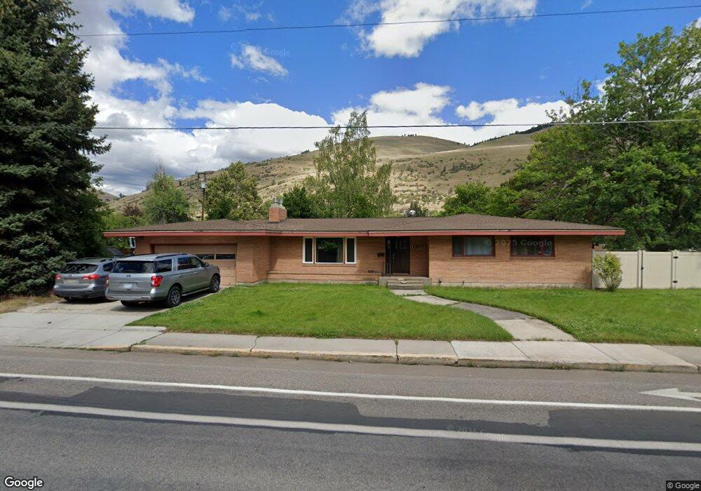
1820 Arthur Ave Missoula, MT 59801
University District NeighborhoodEstimated Value: $885,000 - $967,245
3
Beds
3
Baths
1,813
Sq Ft
$513/Sq Ft
Est. Value
About This Home
This home is located at 1820 Arthur Ave, Missoula, MT 59801 and is currently estimated at $929,311, approximately $512 per square foot. 1820 Arthur Ave is a home located in Missoula County with nearby schools including Paxson School, Washington Middle School, and Hellgate High School.
Ownership History
Date
Name
Owned For
Owner Type
Purchase Details
Closed on
Sep 10, 2007
Sold by
Geraldine H Cardon Revocable Trust
Bought by
Schweyen Andrew and Schweyen Shawn
Current Estimated Value
Home Financials for this Owner
Home Financials are based on the most recent Mortgage that was taken out on this home.
Original Mortgage
$313,960
Outstanding Balance
$199,795
Interest Rate
6.67%
Mortgage Type
Purchase Money Mortgage
Estimated Equity
$729,516
Purchase Details
Closed on
May 30, 2006
Sold by
Cardon William R and Cardon Family Trust
Bought by
Cardon Geraldine H and Cardon Revocable T Geraldine H
Create a Home Valuation Report for This Property
The Home Valuation Report is an in-depth analysis detailing your home's value as well as a comparison with similar homes in the area
Home Values in the Area
Average Home Value in this Area
Purchase History
| Date | Buyer | Sale Price | Title Company |
|---|---|---|---|
| Schweyen Andrew | -- | Insured Titles Llc | |
| Cardon Geraldine H | -- | None Available |
Source: Public Records
Mortgage History
| Date | Status | Borrower | Loan Amount |
|---|---|---|---|
| Open | Schweyen Andrew | $313,960 |
Source: Public Records
Tax History Compared to Growth
Tax History
| Year | Tax Paid | Tax Assessment Tax Assessment Total Assessment is a certain percentage of the fair market value that is determined by local assessors to be the total taxable value of land and additions on the property. | Land | Improvement |
|---|---|---|---|---|
| 2025 | $8,215 | $940,500 | $404,749 | $535,751 |
| 2024 | $7,883 | $647,800 | $297,915 | $349,885 |
| 2023 | $7,596 | $647,800 | $297,915 | $349,885 |
| 2022 | $7,553 | $558,900 | $0 | $0 |
| 2021 | $6,789 | $558,900 | $0 | $0 |
| 2020 | $6,281 | $480,200 | $0 | $0 |
| 2019 | $6,260 | $480,200 | $0 | $0 |
| 2018 | $5,662 | $422,200 | $0 | $0 |
| 2017 | $5,566 | $422,200 | $0 | $0 |
| 2016 | $4,514 | $357,600 | $0 | $0 |
| 2015 | $4,176 | $357,600 | $0 | $0 |
| 2014 | $3,894 | $187,832 | $0 | $0 |
Source: Public Records
Map
Nearby Homes
- 546 Woodworth Ave
- 1700 Arthur Ave
- 401 Woodworth Ave
- 831 Hastings Ave
- 839 Evans Ave
- 340 Evans Ave
- 322 Evans Ave
- 1617 Ronald Ave
- 921 E Beckwith Ave
- 109 E Central Ave
- 101 E Central Ave
- 116 South Ave E
- 1325 Gerald Ave
- Lot 26a South Ave W
- 540 Ford St
- 300 Connell Ave
- 951 Ronald Ave Unit 304
- 542 Eddy Ave
- 2711 S Higgins Ave
- 301 Livingston Ave
- 614 Woodworth Ave
- 620 Woodworth Ave
- 601 Beverly Ave
- 534 Woodworth Ave
- 601 Woodworth Ave
- 619 Beverly Ave
- 611 Woodworth Ave
- 1801 Arthur Ave
- 621 Woodworth Ave
- 530 Woodworth Ave
- 541 Woodworth Ave
- 640 Woodworth Ave
- 545 Beverly Ave
- 629 Beverly Ave
- 625 Woodworth Ave
- 525 Beverly Ave
- 600 North Ave E
- 514 Woodworth Ave
- 521 Woodworth Ave
- 620 North Ave E