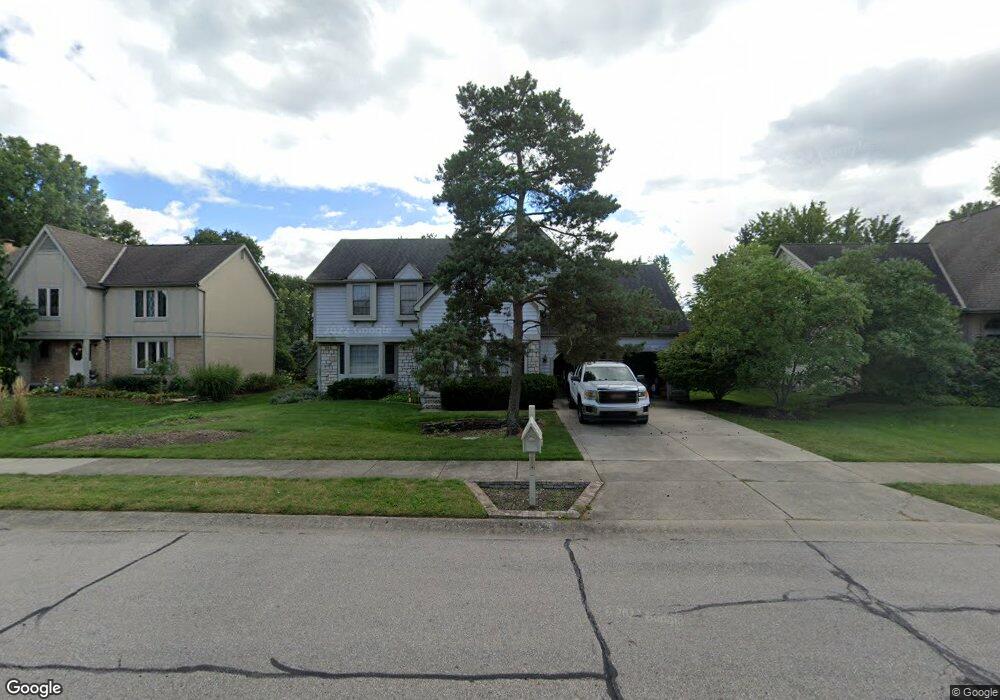
183 Muladore Dr Powell, OH 43065
Estimated Value: $551,000 - $625,000
4
Beds
3
Baths
3,306
Sq Ft
$181/Sq Ft
Est. Value
About This Home
This home is located at 183 Muladore Dr, Powell, OH 43065 and is currently estimated at $598,130, approximately $180 per square foot. 183 Muladore Dr is a home located in Delaware County with nearby schools including Wyandot Run Elementary School, Olentangy Liberty Middle School, and Olentangy High School.
Ownership History
Date
Name
Owned For
Owner Type
Purchase Details
Closed on
Sep 19, 2003
Sold by
Thompson Robert N and Thompson Patricia C
Bought by
Nelson Amy
Current Estimated Value
Home Financials for this Owner
Home Financials are based on the most recent Mortgage that was taken out on this home.
Original Mortgage
$300,000
Outstanding Balance
$162,532
Interest Rate
8.75%
Mortgage Type
Purchase Money Mortgage
Estimated Equity
$435,598
Create a Home Valuation Report for This Property
The Home Valuation Report is an in-depth analysis detailing your home's value as well as a comparison with similar homes in the area
Home Values in the Area
Average Home Value in this Area
Purchase History
| Date | Buyer | Sale Price | Title Company |
|---|---|---|---|
| Nelson Amy | $316,000 | -- |
Source: Public Records
Mortgage History
| Date | Status | Borrower | Loan Amount |
|---|---|---|---|
| Open | Nelson Amy | $300,000 |
Source: Public Records
Tax History
| Year | Tax Paid | Tax Assessment Tax Assessment Total Assessment is a certain percentage of the fair market value that is determined by local assessors to be the total taxable value of land and additions on the property. | Land | Improvement |
|---|---|---|---|---|
| 2024 | $8,551 | $153,200 | $34,830 | $118,370 |
| 2023 | $8,571 | $153,200 | $34,830 | $118,370 |
| 2022 | $8,006 | $120,680 | $26,180 | $94,500 |
| 2021 | $8,626 | $120,680 | $26,180 | $94,500 |
| 2020 | $8,640 | $120,680 | $26,180 | $94,500 |
| 2019 | $7,305 | $104,930 | $22,750 | $82,180 |
| 2018 | $7,370 | $104,930 | $22,750 | $82,180 |
| 2017 | $7,116 | $99,610 | $18,690 | $80,920 |
| 2016 | $7,468 | $99,610 | $18,690 | $80,920 |
| 2015 | $6,819 | $99,610 | $18,690 | $80,920 |
| 2014 | $6,885 | $99,610 | $18,690 | $80,920 |
| 2013 | $6,774 | $95,760 | $18,690 | $77,070 |
Source: Public Records
Map
Nearby Homes
- 170 Barrington Place
- 130 Barrington Place
- 149 Trail Edge Cir
- 92 Barrington Place
- 22 Brookehill Dr
- 156 Meadow Ridge Ct
- 22 Liberty Ridge Ave
- 104 Encore Park Bend
- Irving Plan at Encore Park of Powell - Uptown Collection
- Oakley Plan at Encore Park of Powell - Uptown Collection
- 120 S Liberty St
- 5552 Jessica Ln W
- 1937 Liberty St
- 86 Cressingham Ln
- 18 Murphys View Place Unit I18
- 612 Foxdale Place Unit 612
- 2710 Silverleaf Dr
- 0 Bunker Ln
- 901 Bovee Ln
- 0 Liberty Rd N Unit Lot 4
- 179 Muladore Dr
- 187 Muladore Dr
- 180 Barrington Place
- 175 Muladore Dr
- 199 Paddock Cir W
- 196 Muladore Dr
- 198 Paddock Cir W
- 171 Muladore Dr
- 205 Paddock Cir W
- 161 Beech Ridge Dr
- 201 Muladore Dr
- 201 Paddock Cir E
- 218 Muladore Dr
- 165 Muladore Dr
- 154 Chedworth Row
- 208 Paddock Cir W
- 211 Muladore Dr
- 151 Beech Ridge Dr
- 135 Barrington Place
- 155 Chedworth Row
Your Personal Tour Guide
Ask me questions while you tour the home.