
UNDER CONTRACT
$20K PRICE DROP
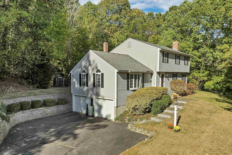
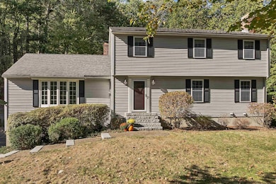
185 Buttrick Rd Hampstead, NH 03841
Estimated payment $4,642/month
Total Views
19,177
3
Beds
2.5
Baths
2,570
Sq Ft
$272
Price per Sq Ft
Highlights
- Popular Property
- Deck
- Garrison Architecture
- Hampstead Middle School Rated A-
- Cathedral Ceiling
- Wood Flooring
About This Home
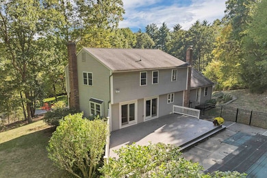
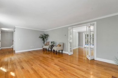
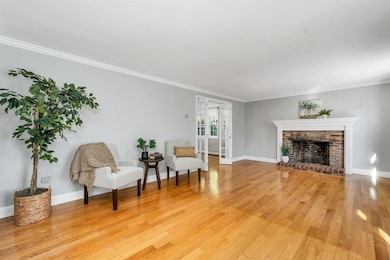
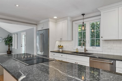
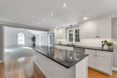
Welcome Home to Hampstead, NH! Looking for your new home? This one might be the perfect fit! Nestled in a desirable walking neighborhood, this spacious 3-bedroom, 3-bath Garrison offers a fantastic layout for any family. Step inside to a warm and inviting living room with a wood-burning fireplace that opens to the dining area and one of two sliders leading to the back deck—perfect for indoor-outdoor entertaining. The large eat-in kitchen is sure to impress with its center island, coffee bar, dining space, second slider to the deck, and even a handy drawer fridge! Off the kitchen, you’ll find a bright and airy great room featuring cathedral ceilings and an abundance of natural light, along with a convenient half bath. Upstairs, the primary bedroom includes its own 3⁄4 bath and walk-in closet, while two additional bedrooms—one with access to a full walk-up attic for extra storage—share another full bath. The lower level provides a functional entry from the garage with plenty of closet space, a bonus room ideal for a home office or gym, and a utility/laundry area. The oversized two-car garage even includes an additional stall perfect for a third vehicle or extra storage. Outside, enjoy the private, fenced-in area featuring an in-ground pool, expansive deck, and a side yard with a storage shed—perfect for summer fun and relaxation. Don’t miss your chance to call this beautiful Hampstead home your own!
Listing Agent
BHHS Verani Realty Hampstead Brokerage Phone: 603-620-1717 Listed on: 10/08/2025
Home Details
Home Type
- Single Family
Est. Annual Taxes
- $11,441
Year Built
- Built in 1983
Lot Details
- 1.08 Acre Lot
- Interior Lot
- Property is zoned A-RES
Parking
- 3 Car Direct Access Garage
- Driveway
- 1 to 5 Parking Spaces
Home Design
- Garrison Architecture
- Concrete Foundation
- Shingle Roof
- Vinyl Siding
Interior Spaces
- Property has 2 Levels
- Cathedral Ceiling
- Whole House Fan
- Ceiling Fan
- Fireplace
- Blinds
- Great Room
- Living Room
- Combination Kitchen and Dining Room
- Bonus Room
- Utility Room
- Washer and Dryer Hookup
Kitchen
- Microwave
- Kitchen Island
Flooring
- Wood
- Carpet
- Tile
Bedrooms and Bathrooms
- 3 Bedrooms
- En-Suite Bathroom
- Walk-In Closet
Basement
- Heated Basement
- Walk-Out Basement
- Interior Basement Entry
Outdoor Features
- Deck
- Outbuilding
Schools
- Hampstead Central Elementary School
- Hampstead Middle School
- Pinkerton Academy High School
Utilities
- Forced Air Heating System
- Drilled Well
Listing and Financial Details
- Tax Lot 000110
- Assessor Parcel Number 000011
Map
Create a Home Valuation Report for This Property
The Home Valuation Report is an in-depth analysis detailing your home's value as well as a comparison with similar homes in the area
Home Values in the Area
Average Home Value in this Area
Tax History
| Year | Tax Paid | Tax Assessment Tax Assessment Total Assessment is a certain percentage of the fair market value that is determined by local assessors to be the total taxable value of land and additions on the property. | Land | Improvement |
|---|---|---|---|---|
| 2024 | $11,441 | $617,100 | $231,700 | $385,400 |
| 2023 | $10,232 | $402,200 | $165,500 | $236,700 |
| 2022 | $9,453 | $399,200 | $165,500 | $233,700 |
| 2021 | $9,082 | $399,200 | $165,500 | $233,700 |
| 2020 | $8,603 | $399,200 | $165,500 | $233,700 |
| 2016 | $7,940 | $328,100 | $113,300 | $214,800 |
| 2015 | $7,359 | $328,100 | $113,300 | $214,800 |
| 2014 | $7,359 | $328,100 | $113,300 | $214,800 |
| 2006 | $6,697 | $369,600 | $132,300 | $237,300 |
Source: Public Records
Property History
| Date | Event | Price | List to Sale | Price per Sq Ft |
|---|---|---|---|---|
| 10/22/2025 10/22/25 | Price Changed | $700,000 | -2.8% | $272 / Sq Ft |
| 10/08/2025 10/08/25 | For Sale | $720,000 | -- | $280 / Sq Ft |
Source: PrimeMLS
Purchase History
| Date | Type | Sale Price | Title Company |
|---|---|---|---|
| Warranty Deed | -- | None Available |
Source: Public Records
Mortgage History
| Date | Status | Loan Amount | Loan Type |
|---|---|---|---|
| Open | $270,900 | Stand Alone Refi Refinance Of Original Loan |
Source: Public Records
About the Listing Agent
What sets me apart? Well, besides my knack for crafting unforgettable deals, I take a refreshingly casual approach to real estate. No stuffy suits or jargon-filled conversations here – just honest, straightforward advice delivered with a smile. Buying a home should be exciting, not stressful, and I'm here to make sure you enjoy every step of the journey.
As a top agent in the area, I've honed my skills in negotiation, marketing, and staging to give my clients a competitive edge. From
Angeline's Other Listings
Source: PrimeMLS
MLS Number: 5064814
APN: HMSD-000011-000110
Disclaimer: Certain information contained herein is derived from information provided by parties other than Homes.com. All information provided is deemed reliable, but is not guaranteed to be accurate and should be independently verified.
![]() Copyright 2025 PrimeMLS, Inc. All rights reserved. This information is deemed reliable, but not guaranteed. The data relating to real estate displayed on this display comes in part from the IDX Program of PrimeMLS. The information being provided is for consumers’ personal, non-commercial use and may not be used for any purpose other than to identify prospective properties consumers may be interested in purchasing.
Copyright 2025 PrimeMLS, Inc. All rights reserved. This information is deemed reliable, but not guaranteed. The data relating to real estate displayed on this display comes in part from the IDX Program of PrimeMLS. The information being provided is for consumers’ personal, non-commercial use and may not be used for any purpose other than to identify prospective properties consumers may be interested in purchasing.
Nearby Homes
- 4 Hastings Dr
- 8 Ians Path
- 6 Johnson Meadow Rd Unit A & B
- 5 Johnson Meadow Rd Unit A & B
- 20 Johnson Meadow Rd Unit A & B
- 32 Ells Rd
- 19 Johnson Meadow Rd Unit A & B
- 30 Johnson Meadow Rd Unit A & B
- 33 Johnson Meadow Rd Unit A & B
- 36 Johnson Meadow Rd Unit A & B
- 23 Stonegate Ln
- 3 Cameron Ct Unit 3
- 5 Grandview Terrace
- 3 Kristopher Dr
- 39 Kibrel Ct
- 33 Pillsbury Rd
- 26 Main St
- 156 Little Mill Rd Unit A
- 50 Page Ln
- 112 Cotton Farm Rd
- 41 Beatrice St Unit D
- 36 Tenney Rd
- 30 Stickney Rd
- 75 Treaty Ct Unit 4
- 24 Dakota Dr Unit 24-2
- 74 Kilrea Rd Unit R
- 15 Shore Dr
- 14 Clare Ln
- 20 Ordway Ln
- 131 Main St Unit 2F
- 67 Rockingham Rd Unit A-1
- 235 Main St
- 1 Silvestri Cir Unit 24
- 3 Pembroke Dr Unit 5
- 2 Pembroke Dr Unit 21
- 1 Forest Ridge Rd
- 144 Main St Unit 2
- 116 E Broadway Unit 2
- 440 North Ave Unit 41
- 332-334 N N