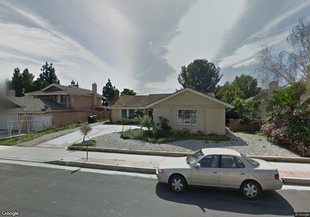
18552 Asuncion St Porter Ranch, CA 91326
Porter Ranch NeighborhoodEstimated Value: $932,655 - $1,077,000
3
Beds
2
Baths
1,428
Sq Ft
$715/Sq Ft
Est. Value
About This Home
This home is located at 18552 Asuncion St, Porter Ranch, CA 91326 and is currently estimated at $1,021,664, approximately $715 per square foot. 18552 Asuncion St is a home located in Los Angeles County with nearby schools including Robert Frost Middle School, Northridge Academy High, and Valley Academy of Arts & Sciences.
Ownership History
Date
Name
Owned For
Owner Type
Purchase Details
Closed on
Feb 19, 2016
Sold by
Kwan Christie F
Bought by
Kwan Christie Faye and The Christie F Kwan Trust
Current Estimated Value
Purchase Details
Closed on
May 17, 1994
Sold by
Stitt Walter C
Bought by
Kwan Christie F
Home Financials for this Owner
Home Financials are based on the most recent Mortgage that was taken out on this home.
Original Mortgage
$152,000
Interest Rate
8.53%
Create a Home Valuation Report for This Property
The Home Valuation Report is an in-depth analysis detailing your home's value as well as a comparison with similar homes in the area
Home Values in the Area
Average Home Value in this Area
Purchase History
| Date | Buyer | Sale Price | Title Company |
|---|---|---|---|
| Kwan Christie Faye | -- | None Available | |
| Kwan Christie F | $190,000 | Guardian Title Company |
Source: Public Records
Mortgage History
| Date | Status | Borrower | Loan Amount |
|---|---|---|---|
| Closed | Kwan Christie F | $152,000 |
Source: Public Records
Tax History
| Year | Tax Paid | Tax Assessment Tax Assessment Total Assessment is a certain percentage of the fair market value that is determined by local assessors to be the total taxable value of land and additions on the property. | Land | Improvement |
|---|---|---|---|---|
| 2025 | $4,119 | $322,908 | $232,502 | $90,406 |
| 2024 | $4,119 | $316,578 | $227,944 | $88,634 |
| 2023 | $4,043 | $310,372 | $223,475 | $86,897 |
| 2022 | $3,864 | $304,288 | $219,094 | $85,194 |
| 2021 | $3,812 | $298,323 | $214,799 | $83,524 |
| 2020 | $3,844 | $295,265 | $212,597 | $82,668 |
| 2019 | $3,702 | $289,477 | $208,429 | $81,048 |
| 2018 | $3,573 | $283,802 | $204,343 | $79,459 |
| 2016 | $3,405 | $272,783 | $196,409 | $76,374 |
| 2015 | $3,356 | $268,686 | $193,459 | $75,227 |
| 2014 | $3,374 | $263,424 | $189,670 | $73,754 |
Source: Public Records
Map
Nearby Homes
- 11348 Reseda Blvd
- 11413 Etiwanda Ave
- 11300 Dulcet Ave
- 18630 Nau Ave
- 11461 Amigo Ave
- 18772 Algiers St
- 18720 San Fernando Mission Blvd
- 18371 Lahey St
- 11625 Baird Ave
- 18525 Entrada Ct
- 11753 Castillo Ln
- 18157 Donmetz St
- 11017 Baird Ave
- 11830 Killimore Ave
- 10953 Darby Ave
- 11215 Wilbur Ave
- 18822 Salt Lake Place
- 11861 Darby Ave
- 18938 Granada Cir
- 11050 Lindley Ave
- 18544 Asuncion St
- 18560 Asuncion St
- 11361 Baird Ave
- 11365 Baird Ave
- 18538 Asuncion St
- 18568 Asuncion St
- 11355 Baird Ave
- 18549 Asuncion St
- 18557 Asuncion St
- 18543 Asuncion St
- 11371 Baird Ave
- 11358 Baird Ave
- 18530 Asuncion St
- 18576 Asuncion St
- 11349 Baird Ave
- 11356 Baird Ave
- 11362 Edenberg Ave
- 18535 Asuncion St
- 18577 Asuncion St
- 18570 Dylan St
Your Personal Tour Guide
Ask me questions while you tour the home.