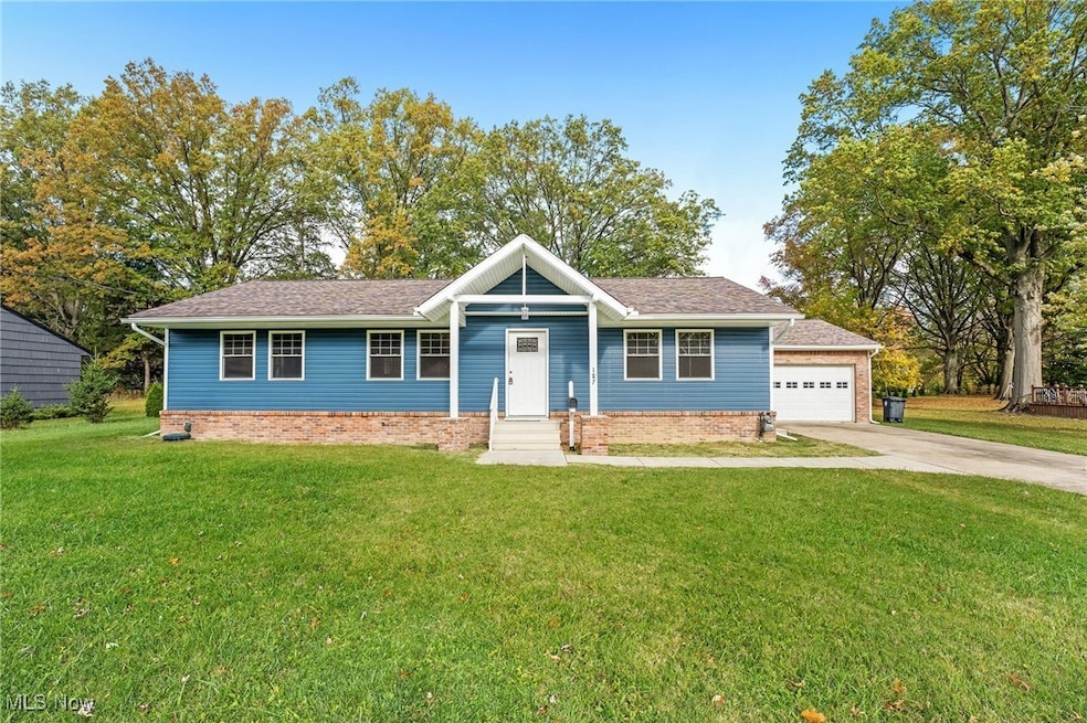


187 Shipherd Cir Oberlin, OH 44074
Estimated payment $2,653/month
Highlights
- Medical Services
- Deck
- 2 Car Direct Access Garage
- Open Floorplan
- No HOA
- Double Pane Windows
About This Home
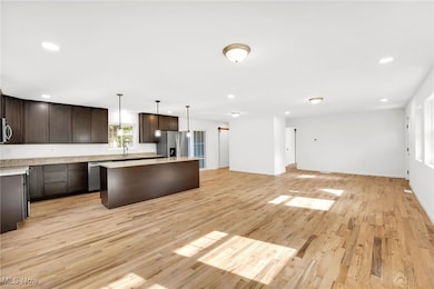
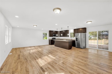
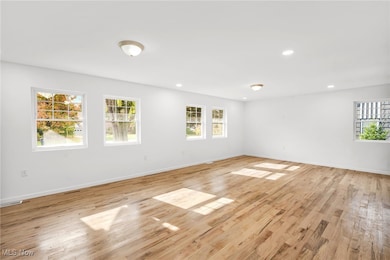
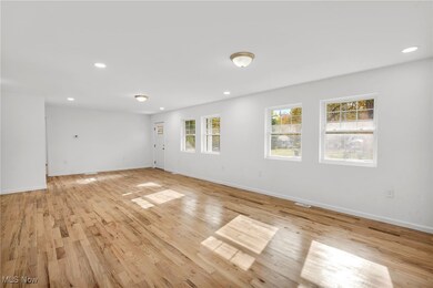
Welcome to 187 Shipherd Cir in Oberlin, a completely gutted and redesigned home that blends modern luxury with thoughtful craftsmanship. This stunning 4-bedroom, 3.5-bath property has been fully updated from top to bottom, featuring new electrical, plumbing, drywall, siding, furnace, A/C, hot water tank, roof, and windows (2020–2025), giving you total peace of mind. Step inside to discover a bright, open-concept layout where the living room, kitchen, and dining area flow seamlessly together, creating the perfect space for entertaining or relaxing. The kitchen is a showstopper, boasting granite countertops, brand-new stainless steel appliances (2025), a large island for gathering, and access to the deck. The master suite offers privacy and comfort, complete with a spacious ensuite bathroom. The 2 additional bedrooms are cozy yet generous in size, and all bathrooms have been beautifully updated. The fully finished basement provides additional living or recreational space, ideal for a home theater, gym, or family room. The fourth bedroom is also in the basement and has its own private bathroom. Outside, you’ll find ample curb appeal with an attached 2-car garage, a 20x20 wood deck out back perfect for summer evenings, a spacious backyard ready for outdoor enjoyment, and an additional parcel to the right to give you even more room. With every detail carefully redone and no expense spared, 187 Shipherd Cir is truly a move-in-ready dream home in a quiet, desirable Oberlin neighborhood.
Listing Agent
RE/MAX Crossroads Properties Brokerage Email: anthonylatinarealestate@gmail.com, 440-465-5611 License #2016003431 Listed on: 10/24/2025

Home Details
Home Type
- Single Family
Est. Annual Taxes
- $5,088
Year Built
- Built in 1954 | Remodeled
Lot Details
- 0.45 Acre Lot
- 09-00-087-106-020
Parking
- 2 Car Direct Access Garage
- Lighted Parking
- Garage Door Opener
Home Design
- Brick Exterior Construction
- Fiberglass Roof
- Asphalt Roof
- Vinyl Siding
Interior Spaces
- 1-Story Property
- Open Floorplan
- Double Pane Windows
- Finished Basement
- Basement Fills Entire Space Under The House
Kitchen
- Range
- Microwave
- Dishwasher
- Kitchen Island
Bedrooms and Bathrooms
- 4 Bedrooms | 3 Main Level Bedrooms
- 3.5 Bathrooms
Outdoor Features
- Deck
Utilities
- Forced Air Heating and Cooling System
- Heating System Uses Gas
Listing and Financial Details
- Assessor Parcel Number 09-00-087-106-019
Community Details
Overview
- No Home Owners Association
- College Park Add Subdivision
Amenities
- Medical Services
- Shops
- Restaurant
Map
Home Values in the Area
Average Home Value in this Area
Tax History
| Year | Tax Paid | Tax Assessment Tax Assessment Total Assessment is a certain percentage of the fair market value that is determined by local assessors to be the total taxable value of land and additions on the property. | Land | Improvement |
|---|---|---|---|---|
| 2024 | $4,509 | $89,656 | $17,595 | $72,062 |
| 2023 | $3,621 | $64,498 | $15,229 | $49,270 |
| 2022 | $3,526 | $64,498 | $15,229 | $49,270 |
| 2021 | $3,519 | $64,498 | $15,229 | $49,270 |
| 2020 | $3,177 | $54,710 | $12,920 | $41,790 |
| 2019 | $2,646 | $54,710 | $12,920 | $41,790 |
| 2018 | $2,601 | $54,710 | $12,920 | $41,790 |
| 2017 | $2,172 | $48,320 | $7,370 | $40,950 |
| 2016 | $2,193 | $48,320 | $7,370 | $40,950 |
| 2015 | $2,196 | $48,320 | $7,370 | $40,950 |
| 2014 | $2,200 | $45,590 | $6,960 | $38,630 |
| 2013 | $2,059 | $45,590 | $6,960 | $38,630 |
Property History
| Date | Event | Price | List to Sale | Price per Sq Ft |
|---|---|---|---|---|
| 10/24/2025 10/24/25 | For Sale | $424,900 | -- | $152 / Sq Ft |
Purchase History
| Date | Type | Sale Price | Title Company |
|---|---|---|---|
| Quit Claim Deed | -- | None Listed On Document | |
| Quit Claim Deed | -- | Spike Legal Group Llc | |
| Quit Claim Deed | -- | None Available | |
| Survivorship Deed | $65,000 | Chicago Title Insurance Co | |
| Certificate Of Transfer | -- | None Available |
Mortgage History
| Date | Status | Loan Amount | Loan Type |
|---|---|---|---|
| Previous Owner | $291,750 | New Conventional |
Source: MLS Now
MLS Number: 5166166
APN: 09-00-087-106-019
Disclaimer: Certain information contained herein is derived from information provided by parties other than Homes.com. All information provided is deemed reliable, but is not guaranteed to be accurate and should be independently verified.
![]() IDX information is provided exclusively for personal, non-commercial use, and may not be used for any purpose other than to identify prospective properties consumers may be interested in purchasing. Information is deemed reliable but not guaranteed.
IDX information is provided exclusively for personal, non-commercial use, and may not be used for any purpose other than to identify prospective properties consumers may be interested in purchasing. Information is deemed reliable but not guaranteed.
- 152 Shipherd Cir
- 95 Shipherd Cir
- 248 Shipherd Cir
- 110 Shipherd Cir
- 118 Locust St
- 59 E Vine St
- 62 Locust St
- 126 N Park St
- 182 E Hamilton St
- 44867 E Hamilton St
- 296 S Pleasant St
- 89 S Professor St
- 81 S Professor St
- 121 S Professor St
- 123 S Professor St
- 216 N Main St
- 230 N Main St
- 147 Morgan St
- 149 Morgan St
- 14409 State Route 58
- 55 E College St Unit 212
- 99 Smith St Unit B
- 129 N Main St Unit Suite 200
- 41 S Cedar St
- 37 S Cedar St
- 198 Keywood Blvd
- 100 Cedar Brook Dr
- 1952-1960 Fowl Rd
- 230 Brunswick Dr
- 103 Cheshire Dr
- 731 Infirmary Rd
- 1120 Red Thimbleberry Dr
- 47510-47534 Middle Ridge Rd
- 403 Palomino Ct
- 403 Palomino Ct Unit SingleFamilyHomeRanch
- 213 George St
- 218 Gates Ave Unit 1/DN
- 329 5th St
- 329 5th St
- 1100 Oakwood Dr