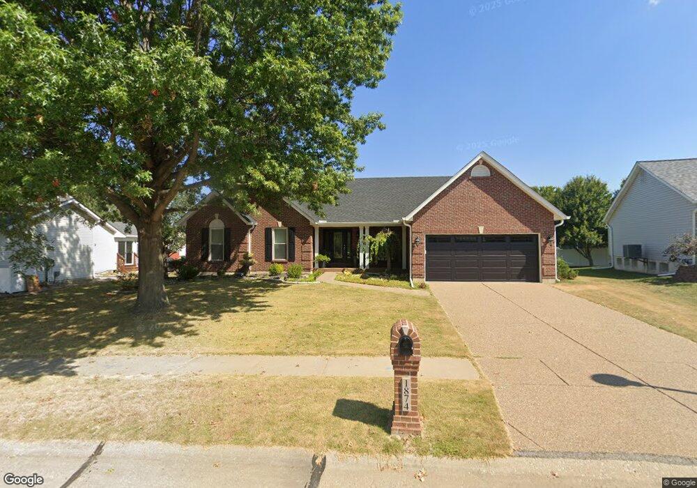
1874 Highgrove Dr O Fallon, MO 63366
Estimated Value: $389,678 - $438,000
3
Beds
2
Baths
2,115
Sq Ft
$199/Sq Ft
Est. Value
About This Home
This home is located at 1874 Highgrove Dr, O Fallon, MO 63366 and is currently estimated at $421,420, approximately $199 per square foot. 1874 Highgrove Dr is a home located in St. Charles County with nearby schools including Westhoff Elementary School, Fort Zumwalt North Middle School, and Fort Zumwalt North High School.
Ownership History
Date
Name
Owned For
Owner Type
Purchase Details
Closed on
Nov 2, 2010
Sold by
Howland William F and Howland Laura A
Bought by
Howland William F and Howland Laura A
Current Estimated Value
Home Financials for this Owner
Home Financials are based on the most recent Mortgage that was taken out on this home.
Original Mortgage
$90,000
Interest Rate
4.32%
Mortgage Type
New Conventional
Purchase Details
Closed on
Nov 10, 2005
Sold by
Howland William F and Howland Laura A
Bought by
Howland William F and Howland Laura A
Purchase Details
Closed on
Nov 28, 1997
Sold by
Whittaker Construction Inc
Bought by
Howland William F and Howland Laura A
Home Financials for this Owner
Home Financials are based on the most recent Mortgage that was taken out on this home.
Original Mortgage
$107,000
Interest Rate
7.3%
Create a Home Valuation Report for This Property
The Home Valuation Report is an in-depth analysis detailing your home's value as well as a comparison with similar homes in the area
Home Values in the Area
Average Home Value in this Area
Purchase History
| Date | Buyer | Sale Price | Title Company |
|---|---|---|---|
| Howland William F | -- | Inv | |
| Howland William F | -- | None Available | |
| Howland William F | -- | -- |
Source: Public Records
Mortgage History
| Date | Status | Borrower | Loan Amount |
|---|---|---|---|
| Closed | Howland William F | $90,000 | |
| Closed | Howland William F | $107,000 |
Source: Public Records
Tax History
| Year | Tax Paid | Tax Assessment Tax Assessment Total Assessment is a certain percentage of the fair market value that is determined by local assessors to be the total taxable value of land and additions on the property. | Land | Improvement |
|---|---|---|---|---|
| 2025 | $4,488 | $73,758 | -- | -- |
| 2023 | $4,490 | $67,941 | $0 | $0 |
| 2022 | $3,657 | $51,413 | $0 | $0 |
| 2021 | $3,660 | $51,413 | $0 | $0 |
| 2020 | $4,006 | $54,558 | $0 | $0 |
| 2019 | $4,015 | $54,558 | $0 | $0 |
| 2018 | $3,774 | $48,943 | $0 | $0 |
| 2017 | $3,730 | $48,943 | $0 | $0 |
| 2016 | $3,178 | $41,530 | $0 | $0 |
| 2015 | $2,955 | $41,530 | $0 | $0 |
| 2014 | $2,776 | $38,366 | $0 | $0 |
Source: Public Records
Map
Nearby Homes
- 730 Homerun Dr Unit 76N
- 2837 Grand Slam Dr
- 1818 Sapling Dr
- 1805 Sapling Dr
- 634 Homerun Dr Unit 34N
- 632 Homerun Dr Unit 33N
- 17 Homefield Gardens Dr
- 811 Homefield Grove Ct
- 1358 Deerfield Estates Dr
- 1612 Homefield Meadows Dr
- 231 England Dr
- 487 Chatham Dr
- 31 Piepers Glen Ct
- 214 Maryland Dr Unit 26B
- 1102 Danielle Elizabeth Ct
- 0 Tom Ginnever Ave
- 6 S Boxwood Ln
- 201 Allen Dr
- 409 Saint Joseph Ave
- 805 Saint Joseph Ave
- 1870 Highgrove Dr
- 1878 Highgrove Dr
- 1705 Highgrove Dr
- 269 Gentry Dr
- 273 Gentry Dr
- 261 Gentry Dr
- 1709 Highgrove Dr
- 1875 Highgrove Dr
- 1869 Highgrove Dr
- 7 Wales Ct
- 5 Wales Ct
- 1713 Highgrove Dr
- 1865 Highgrove Dr
- 281 Gentry Dr
- 270 Gentry Dr
- 266 Gentry Dr
- 6 Wales Ct
- 274 Gentry Dr
- 1714 Highgrove Dr
- 1902 Royal Heir Dr
Your Personal Tour Guide
Ask me questions while you tour the home.