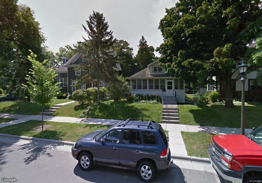
1890 Lincoln Ave Saint Paul, MN 55105
Macalester-Groveland NeighborhoodEstimated Value: $362,000 - $436,000
4
Beds
2
Baths
1,183
Sq Ft
$337/Sq Ft
Est. Value
About This Home
This home is located at 1890 Lincoln Ave, Saint Paul, MN 55105 and is currently estimated at $399,094, approximately $337 per square foot. 1890 Lincoln Ave is a home located in Ramsey County with nearby schools including Groveland Park Elementary School, Hidden River Middle School, and Central Senior High School.
Ownership History
Date
Name
Owned For
Owner Type
Purchase Details
Closed on
Jun 26, 2025
Sold by
Arndt Carrie
Bought by
Toledo-Silvestre Maria Isabel and Honl Chad Ignatius
Current Estimated Value
Purchase Details
Closed on
Apr 14, 2014
Sold by
Neill Joshua R O and Neill Angela M O
Bought by
Arndt Carrie
Home Financials for this Owner
Home Financials are based on the most recent Mortgage that was taken out on this home.
Original Mortgage
$210,000
Outstanding Balance
$159,579
Interest Rate
4.33%
Estimated Equity
$239,515
Purchase Details
Closed on
May 9, 2006
Sold by
Gross Harry Heinz
Bought by
Oneill Joshua R and Oneill Diane M
Create a Home Valuation Report for This Property
The Home Valuation Report is an in-depth analysis detailing your home's value as well as a comparison with similar homes in the area
Home Values in the Area
Average Home Value in this Area
Purchase History
| Date | Buyer | Sale Price | Title Company |
|---|---|---|---|
| Toledo-Silvestre Maria Isabel | $375,000 | -- | |
| Arndt Carrie | $288,484 | Realstar Title | |
| Oneill Joshua R | $240,000 | -- |
Source: Public Records
Mortgage History
| Date | Status | Borrower | Loan Amount |
|---|---|---|---|
| Open | Arndt Carrie | $210,000 |
Source: Public Records
Tax History Compared to Growth
Tax History
| Year | Tax Paid | Tax Assessment Tax Assessment Total Assessment is a certain percentage of the fair market value that is determined by local assessors to be the total taxable value of land and additions on the property. | Land | Improvement |
|---|---|---|---|---|
| 2025 | $5,746 | $413,800 | $165,500 | $248,300 |
| 2023 | $5,746 | $362,800 | $165,500 | $197,300 |
| 2022 | $5,594 | $367,500 | $165,500 | $202,000 |
| 2021 | $5,502 | $344,700 | $165,500 | $179,200 |
| 2020 | $5,690 | $351,800 | $165,500 | $186,300 |
| 2019 | $5,856 | $337,800 | $165,500 | $172,300 |
| 2018 | $5,206 | $343,500 | $165,500 | $178,000 |
| 2017 | $4,724 | $313,700 | $165,500 | $148,200 |
| 2016 | $4,808 | $0 | $0 | $0 |
| 2015 | $3,896 | $288,900 | $137,900 | $151,000 |
| 2014 | $4,334 | $0 | $0 | $0 |
Source: Public Records
Map
Nearby Homes
- 1926 Lincoln Ave
- 1917 Summit Ave Unit 2
- 2009 Grand Ave
- 2047 Grand Ave
- 2056 Summit Ave
- 188 Cleveland Ave S
- 1920 Laurel Ave
- 191 Vernon St
- 281 Cleveland Ave S
- 1821 Selby Ave
- 1670 Ashland Ave
- 2133 Berkeley Ave
- 2129 Stanford Ave
- 1836 Marshall Ave
- 1818 Juliet Ave
- 1798 Marshall Ave
- 1615 Stanford Ave
- 2096 Dayton Ave
- 2248 Goodrich Ave
- 1796 Iglehart Ave
- 1884 Lincoln Ave
- 1900 Lincoln Ave
- 1902 Lincoln Ave
- 1880 Lincoln Ave
- 1889 Goodrich Ave
- 1906 Lincoln Ave
- 1906 1906 Lincoln Ave
- 1895 Goodrich Ave
- 1883 Goodrich Ave
- 1901 Goodrich Ave
- 1887 Lincoln Ave
- 1883 Lincoln Ave
- 1910 Lincoln Ave
- 1895 Lincoln Ave
- 1897 Lincoln Ave
- 1907 Goodrich Ave
- 1877 Goodrich Ave
- 1871 1871 Lincoln Ave
- 1866 Lincoln Ave
- 1871 Lincoln Ave