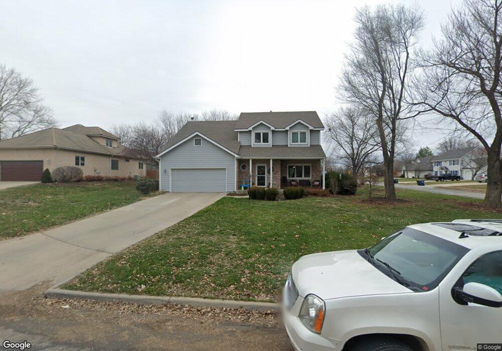
1900 Spyglass Ct Lawrence, KS 66047
Estimated Value: $437,151 - $446,000
3
Beds
3
Baths
2,107
Sq Ft
$209/Sq Ft
Est. Value
About This Home
This home is located at 1900 Spyglass Ct, Lawrence, KS 66047 and is currently estimated at $440,288, approximately $208 per square foot. 1900 Spyglass Ct is a home located in Douglas County with nearby schools including Sunflower Elementary School, Southwest Middle School, and Lawrence High School.
Ownership History
Date
Name
Owned For
Owner Type
Purchase Details
Closed on
Nov 5, 2020
Sold by
Kent Orean H and Orean H Kent Trust
Bought by
Santee Trent D and Sautee Kiley J
Current Estimated Value
Home Financials for this Owner
Home Financials are based on the most recent Mortgage that was taken out on this home.
Original Mortgage
$335,750
Interest Rate
2.8%
Mortgage Type
Construction
Purchase Details
Closed on
Aug 14, 2001
Sold by
Kent Orean H and Kent David W
Bought by
Kent Orean H and Orean H Kent Trust
Create a Home Valuation Report for This Property
The Home Valuation Report is an in-depth analysis detailing your home's value as well as a comparison with similar homes in the area
Home Values in the Area
Average Home Value in this Area
Purchase History
| Date | Buyer | Sale Price | Title Company |
|---|---|---|---|
| Santee Trent D | -- | Security 1St Title | |
| Kent Orean H | -- | -- | |
| Kent Orean H | -- | -- |
Source: Public Records
Mortgage History
| Date | Status | Borrower | Loan Amount |
|---|---|---|---|
| Closed | Santee Trent D | $335,750 |
Source: Public Records
Tax History Compared to Growth
Tax History
| Year | Tax Paid | Tax Assessment Tax Assessment Total Assessment is a certain percentage of the fair market value that is determined by local assessors to be the total taxable value of land and additions on the property. | Land | Improvement |
|---|---|---|---|---|
| 2025 | $5,768 | $47,380 | $7,475 | $39,905 |
| 2024 | $5,768 | $46,299 | $7,475 | $38,824 |
| 2023 | $5,747 | $44,563 | $7,475 | $37,088 |
| 2022 | $5,298 | $40,837 | $7,475 | $33,362 |
| 2021 | $4,644 | $34,730 | $6,334 | $28,396 |
| 2020 | $4,016 | $30,233 | $6,334 | $23,899 |
| 2019 | $3,984 | $30,026 | $6,334 | $23,692 |
| 2018 | $3,919 | $29,325 | $6,334 | $22,991 |
| 2017 | $3,918 | $28,991 | $6,334 | $22,657 |
| 2016 | $3,683 | $28,474 | $5,173 | $23,301 |
| 2015 | $3,725 | $28,785 | $5,173 | $23,612 |
| 2014 | $3,727 | $29,084 | $5,173 | $23,911 |
Source: Public Records
Map
Nearby Homes
- 4709 Carmel Place
- 4617 Merion Ct
- 2009 Riviera Ct
- 1601 Research Park Dr
- 1608 Prestwick Dr
- 2101 Riviera Dr
- 2109 Riviera Dr
- 4206 Nicklaus Dr
- 1616 Prestwick Dr
- 4500 Bob Billings Pkwy Unit 408
- 2100 Inverness Dr
- 4312 Wimbledon Dr
- 1315 Research Park Dr
- 1564 Fountain Dr
- 1406 Brighton Cir Unit B
- 1300 Research Park Dr
- 4812 Tempe St
- 1404 Legends Ct
- 2429 Via Linda Dr
- 4400 Gretchen Ct
- 1816 Carmel Dr
- 1904 Spyglass Ct
- 1820 Alvamar Place
- 1812 Carmel Dr
- 1816 Alvamar Place
- 1908 Spyglass Ct
- 1901 Carmel Dr
- 1821 Carmel Dr
- 1920 Spyglass Ct
- 1812 Alvamar Place
- 1808 Carmel Dr
- 1817 Carmel Dr
- 1905 Carmel Dr
- 1916 Spyglass Ct
- 1809 Alvamar Place
- 1912 Spyglass Ct
- 1808 Alvamar Place
- 1804 Carmel Dr
- 1909 Carmel Dr
- 1804 Alvamar Place