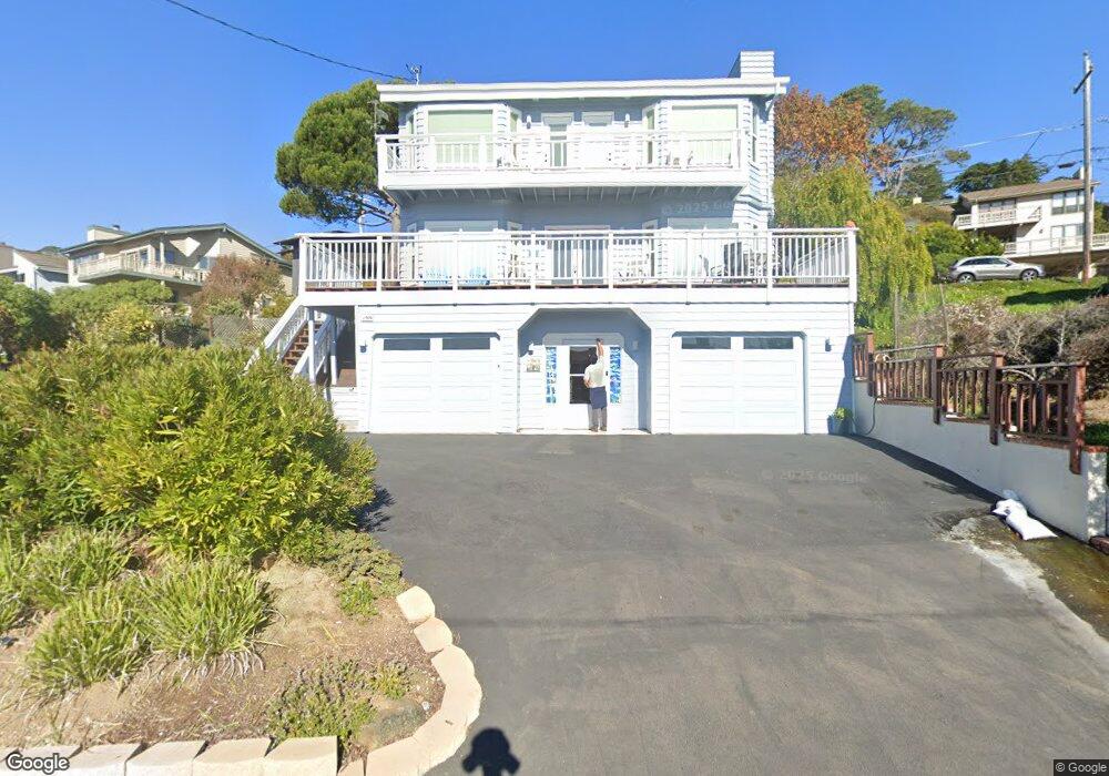
1906 Oxford Ave Cambria, CA 93428
Cambria NeighborhoodEstimated Value: $1,319,534 - $1,488,000
3
Beds
2
Baths
1,813
Sq Ft
$777/Sq Ft
Est. Value
About This Home
This home is located at 1906 Oxford Ave, Cambria, CA 93428 and is currently estimated at $1,408,134, approximately $776 per square foot. 1906 Oxford Ave is a home located in San Luis Obispo County with nearby schools including Cambria Grammar, Santa Lucia Middle School, and Coast Union High School.
Ownership History
Date
Name
Owned For
Owner Type
Purchase Details
Closed on
Sep 7, 2022
Sold by
Farnam and Cristin
Bought by
Farnam Family Trust
Current Estimated Value
Purchase Details
Closed on
Mar 9, 2012
Sold by
Farnam Michael A and Farnam Cristin C
Bought by
Farnam Michael A and Farnam Cristin C
Home Financials for this Owner
Home Financials are based on the most recent Mortgage that was taken out on this home.
Original Mortgage
$290,000
Interest Rate
3.83%
Mortgage Type
New Conventional
Purchase Details
Closed on
Feb 16, 2011
Sold by
Farnam Michael A and Farnam Cristin C
Bought by
Farnam Michael A and Farnam Cristin C
Home Financials for this Owner
Home Financials are based on the most recent Mortgage that was taken out on this home.
Original Mortgage
$496,000
Interest Rate
4.74%
Mortgage Type
New Conventional
Purchase Details
Closed on
Feb 14, 2011
Sold by
Lockwood Thomas A and Lockwood Nancy L
Bought by
Farnam Michael A and Farnam Cristin C
Home Financials for this Owner
Home Financials are based on the most recent Mortgage that was taken out on this home.
Original Mortgage
$496,000
Interest Rate
4.74%
Mortgage Type
New Conventional
Purchase Details
Closed on
May 21, 2007
Sold by
Elles Charles and Elles Mary
Bought by
Lockwood Thomas A and Lockwood Nancy E
Home Financials for this Owner
Home Financials are based on the most recent Mortgage that was taken out on this home.
Original Mortgage
$91,400
Interest Rate
6.36%
Mortgage Type
Stand Alone Second
Purchase Details
Closed on
Mar 3, 2006
Sold by
Elles Charles and Elles Mary
Bought by
Elles Charles and Elles Mary
Home Financials for this Owner
Home Financials are based on the most recent Mortgage that was taken out on this home.
Original Mortgage
$510,000
Interest Rate
6.19%
Mortgage Type
New Conventional
Create a Home Valuation Report for This Property
The Home Valuation Report is an in-depth analysis detailing your home's value as well as a comparison with similar homes in the area
Home Values in the Area
Average Home Value in this Area
Purchase History
| Date | Buyer | Sale Price | Title Company |
|---|---|---|---|
| Farnam Family Trust | -- | -- | |
| Farnam Michael | -- | -- | |
| Farnam Michael A | -- | Multiple | |
| Farnam Michael A | -- | Chicago Title Company | |
| Farnam Michael A | -- | Accommodation | |
| Farnam Michael A | $620,000 | First American Title Company | |
| Lockwood Thomas A | $915,000 | First American Title Co | |
| Elles Charles | -- | First American Title Co |
Source: Public Records
Mortgage History
| Date | Status | Borrower | Loan Amount |
|---|---|---|---|
| Previous Owner | Farnam Michael A | $290,000 | |
| Previous Owner | Farnam Michael A | $496,000 | |
| Previous Owner | Lockwood Thomas A | $91,400 | |
| Previous Owner | Lockwood Thomas A | $732,000 | |
| Previous Owner | Elles Charles | $510,000 |
Source: Public Records
Tax History Compared to Growth
Tax History
| Year | Tax Paid | Tax Assessment Tax Assessment Total Assessment is a certain percentage of the fair market value that is determined by local assessors to be the total taxable value of land and additions on the property. | Land | Improvement |
|---|---|---|---|---|
| 2025 | $8,620 | $803,285 | $448,405 | $354,880 |
| 2024 | $8,473 | $787,535 | $439,613 | $347,922 |
| 2023 | $8,473 | $772,094 | $430,994 | $341,100 |
| 2022 | $8,307 | $756,956 | $422,544 | $334,412 |
| 2021 | $8,187 | $742,114 | $414,259 | $327,855 |
| 2020 | $8,095 | $734,506 | $410,012 | $324,494 |
| 2019 | $7,939 | $720,105 | $401,973 | $318,132 |
| 2018 | $7,783 | $705,987 | $394,092 | $311,895 |
| 2017 | $7,628 | $692,145 | $386,365 | $305,780 |
| 2016 | $7,479 | $678,575 | $378,790 | $299,785 |
| 2015 | $7,373 | $668,383 | $373,101 | $295,282 |
| 2014 | $7,115 | $655,291 | $365,793 | $289,498 |
Source: Public Records
Map
Nearby Homes
- 605 Ardath Dr
- 1970 Emmons Rd
- 0 Oxford Ave
- 1799 Saint Thomas Ave
- 740 Ardath Dr
- 395 Ivar St
- 379 Harvey St
- 305 Ivar St
- 0 Madison Unit SC25216306
- 1980 Sherwood Dr
- 798 Drake St
- 1606 Saint James Rd
- 396 Castle St
- 1955 Avon Ave
- 0 Tully Place Unit SC25234309
- 0 Tully Place Unit SC22204783
- 0 Kenneth Dr Unit SC24012358
- 0 Kenneth Dr Unit SC25087439
- 1818 Tweed Ave
- 13 Tweed Ave
- 625 Ardath Dr
- 1936 Emmons Rd
- 1911 Oxford Ave
- 1901 Oxford Ave
- 629 Ardath Dr
- 1881 Oxford Ave
- 1945 Oxford Ave
- 610 Ardath Dr
- 631 Ardath Dr
- Oxford Dr
- 1861 Oxford Ave
- 626 Ardath Dr
- 606 Ardath Dr
- 1910 Marlborough Ln
- 630 Ardath Dr
- 1890 Marlborough Ln
- 440 Kerwin St
- 570 Ardath Dr
- 1857 Oxford Ave
- 635 Ardath Dr