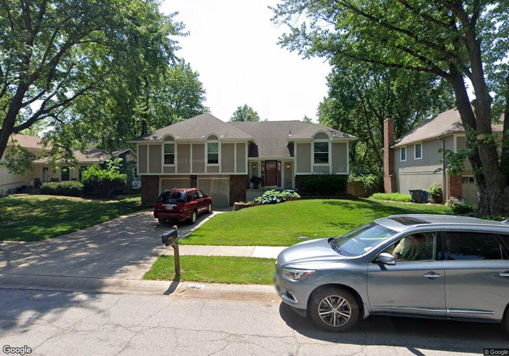
1917 E 152nd St Olathe, KS 66062
Estimated Value: $335,000 - $377,000
4
Beds
3
Baths
1,603
Sq Ft
$224/Sq Ft
Est. Value
About This Home
This home is located at 1917 E 152nd St, Olathe, KS 66062 and is currently estimated at $359,091, approximately $224 per square foot. 1917 E 152nd St is a home located in Johnson County with nearby schools including Scarborough Elementary School, Indian Trail Middle School, and Olathe South Sr High School.
Ownership History
Date
Name
Owned For
Owner Type
Purchase Details
Closed on
Mar 14, 2018
Sold by
Vaughn James Michael and Vaughn Patricia Ann
Bought by
Wingfield Melinda Kathern and Wingfield Richard Kent
Current Estimated Value
Purchase Details
Closed on
Mar 30, 2011
Sold by
Federal National Mortgage Association
Bought by
Vaughn James M and Vaughn Patricia A
Purchase Details
Closed on
Aug 12, 2010
Sold by
Vanlehn John Jacob and Vanlehn John
Bought by
Federal National Mortgage Association
Purchase Details
Closed on
Jun 12, 2007
Sold by
Ebben Joel D and Ebben Leann E
Bought by
Vanlehn John Jacob
Home Financials for this Owner
Home Financials are based on the most recent Mortgage that was taken out on this home.
Original Mortgage
$168,000
Interest Rate
6.41%
Mortgage Type
New Conventional
Create a Home Valuation Report for This Property
The Home Valuation Report is an in-depth analysis detailing your home's value as well as a comparison with similar homes in the area
Home Values in the Area
Average Home Value in this Area
Purchase History
| Date | Buyer | Sale Price | Title Company |
|---|---|---|---|
| Wingfield Melinda Kathern | -- | None Available | |
| Vaughn James M | -- | Stewart Title | |
| Federal National Mortgage Association | $209,192 | Continental Title | |
| Vanlehn John Jacob | -- | First American Title Insuran |
Source: Public Records
Mortgage History
| Date | Status | Borrower | Loan Amount |
|---|---|---|---|
| Previous Owner | Vanlehn John Jacob | $168,000 |
Source: Public Records
Tax History
| Year | Tax Paid | Tax Assessment Tax Assessment Total Assessment is a certain percentage of the fair market value that is determined by local assessors to be the total taxable value of land and additions on the property. | Land | Improvement |
|---|---|---|---|---|
| 2025 | $3,714 | $34,247 | $7,568 | $26,679 |
| 2024 | $3,714 | $33,373 | $6,878 | $26,495 |
| 2023 | $3,444 | $30,257 | $6,256 | $24,001 |
| 2022 | $3,218 | $27,508 | $5,442 | $22,066 |
| 2021 | $3,163 | $25,668 | $5,442 | $20,226 |
| 2020 | $3,002 | $24,162 | $4,944 | $19,218 |
| 2019 | $2,915 | $23,311 | $4,942 | $18,369 |
| 2018 | $2,809 | $22,310 | $4,950 | $17,360 |
| 2017 | $2,549 | $20,067 | $4,120 | $15,947 |
| 2016 | $2,264 | $18,308 | $4,120 | $14,188 |
| 2015 | $2,016 | $16,353 | $3,434 | $12,919 |
| 2013 | -- | $13,651 | $3,434 | $10,217 |
Source: Public Records
Map
Nearby Homes
- 1836 E 153rd Cir
- 2027 E Mohawk Ct
- 0 E 151st St
- 2120 S Lindenwood Dr
- 16720 W 155th Terrace
- 15437 S Bradley Dr
- C 151st St
- 16545 W 153rd St
- 1508 S Pawnee Cir
- 15482 S Wyandotte Dr
- 2128 S Lennox Dr
- 16764 W 157th St
- 15404 S Summertree Ln
- 16021 W 153rd St
- 14747 S Homestead Dr
- 16104 W 154th St
- 1300 E 153rd St
- 2020 E Cherokee Place
- 14739 S Locust St
- 2101 E Sheridan Bridge Ln
- 1921 E 152nd St
- 1913 E 152nd St
- 1925 E 152nd St
- 1909 E 152nd St
- 1908 E 152nd Terrace
- 1912 E 152nd Terrace
- 1904 E 152nd Terrace
- 1914 E 152nd St
- 1916 E 152nd Terrace
- 1830 S Abbey Cir
- 1830 S Arrowhead Dr
- 2001 E 152nd St
- 1905 E 152nd St
- 1900 E 152nd Terrace
- 1826 S Abbey Cir
- 2000 E 152nd Terrace
- 1826 S Arrowhead Dr
- 2005 E 152nd St
- 1901 E 152nd St
- 1825 S Arrowhead Dr
Your Personal Tour Guide
Ask me questions while you tour the home.