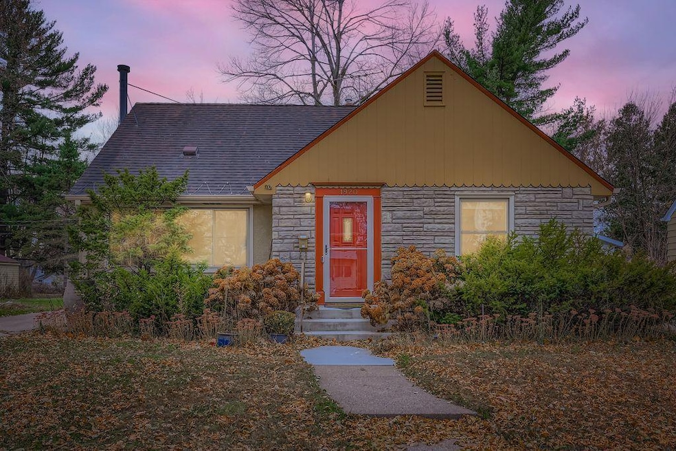
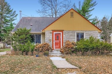
1920 Margaret St Saint Paul, MN 55119
Battle Creek NeighborhoodEstimated payment $1,770/month
Highlights
- Wood Burning Stove
- Main Floor Primary Bedroom
- No HOA
- Radiant Floor
- Bonus Room
- Walk-In Pantry
About This Home
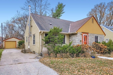
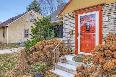
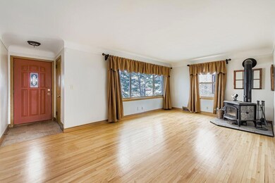
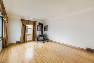
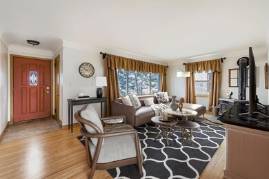
Mid-century charmer! Classic 1.5-story stucco and stone home has retained many of the original features including original hardwood floors, lovely archways, and natural woodwork. Many updates have been done over the years including a new furnace, water heater and updates to the boiler system all in 2025. This home uses two heating systems - hot water (boiler) for part of the first floor and the upper and lower levels, and forced air for the rest of the main level. A wood burner in the living room provides extra warmth and ambiance for those cold winter nights that, let's face it, we know are coming! The back patio
looks out over an extra deep (over 1/3 acre!) yard, a portion of which is fenced. Beyond the fence is a small garden area already fenced and ready for spring planting! Enjoy exploring all the surprises next spring to include mature trees, perennials, raspberries and ???...enjoy the patio area to dream up your own plans - maybe a play area for little ones, a new outdoor social space - firepit anyone? Easy to use Vivent alarm system should be transferrable to new owners if desired. Convenient location is close to 3M,
shops, parks, public transport lines and a new city athletic field. Quick close possible. This one is ready and waiting for your vision to make it your own!

Home Details
Home Type
- Single Family
Est. Annual Taxes
- $3,865
Year Built
- Built in 1952
Lot Details
- 0.34 Acre Lot
- Lot Dimensions are 50x293
- Partially Fenced Property
- Chain Link Fence
- Many Trees
Parking
- 1 Car Garage
- Garage Door Opener
Home Design
- Wood Siding
Interior Spaces
- 1.5-Story Property
- Wood Burning Stove
- Family Room
- Living Room with Fireplace
- Dining Room
- Bonus Room
- Radiant Floor
Kitchen
- Eat-In Kitchen
- Walk-In Pantry
- Microwave
- Dishwasher
- Stainless Steel Appliances
- The kitchen features windows
Bedrooms and Bathrooms
- 2 Bedrooms
- Primary Bedroom on Main
- 1 Full Bathroom
Laundry
- Laundry Room
- Dryer
- Washer
Partially Finished Basement
- Basement Fills Entire Space Under The House
- Block Basement Construction
- Basement Storage
Outdoor Features
- Patio
Utilities
- Central Air
- Window Unit Cooling System
- Baseboard Heating
- Boiler Heating System
- 100 Amp Service
- Gas Water Heater
- High Speed Internet
Community Details
- No Home Owners Association
- Robert L Wares Eastern Heights Subdivision
Listing and Financial Details
- Assessor Parcel Number 352922210067
Map
Home Values in the Area
Average Home Value in this Area
Tax History
| Year | Tax Paid | Tax Assessment Tax Assessment Total Assessment is a certain percentage of the fair market value that is determined by local assessors to be the total taxable value of land and additions on the property. | Land | Improvement |
|---|---|---|---|---|
| 2025 | $4,348 | $256,600 | $54,500 | $202,100 |
| 2023 | $4,348 | $269,300 | $33,900 | $235,400 |
| 2022 | $3,750 | $261,900 | $33,900 | $228,000 |
| 2021 | $2,974 | $220,700 | $33,900 | $186,800 |
| 2020 | $2,790 | $191,900 | $33,900 | $158,000 |
| 2019 | $2,494 | $172,700 | $33,900 | $138,800 |
| 2018 | $2,214 | $162,600 | $33,900 | $128,700 |
| 2017 | $2,148 | $151,400 | $33,900 | $117,500 |
| 2016 | $1,968 | $0 | $0 | $0 |
| 2015 | $1,916 | $137,600 | $33,900 | $103,700 |
| 2014 | $1,520 | $0 | $0 | $0 |
Property History
| Date | Event | Price | List to Sale | Price per Sq Ft |
|---|---|---|---|---|
| 11/20/2025 11/20/25 | For Sale | $275,000 | -- | $184 / Sq Ft |
Purchase History
| Date | Type | Sale Price | Title Company |
|---|---|---|---|
| Quit Claim Deed | $500 | None Available | |
| Warranty Deed | $515 | None Available | |
| Warranty Deed | $145,000 | -- |
Source: NorthstarMLS
MLS Number: 6812545
APN: 35-29-22-21-0067
Disclaimer: Certain information contained herein is derived from information provided by parties other than Homes.com. All information provided is deemed reliable, but is not guaranteed to be accurate and should be independently verified.
![]() Based on information submitted to the MLS GRID. All data is obtained from various sources and may not have been verified by broker or MLS GRID. Supplied Open House Information is subject to change without notice. All information should be independently reviewed and verified for accuracy. Properties may or may not be listed by the office/agent presenting the information. Some IDX listings have been excluded from this website.
Based on information submitted to the MLS GRID. All data is obtained from various sources and may not have been verified by broker or MLS GRID. Supplied Open House Information is subject to change without notice. All information should be independently reviewed and verified for accuracy. Properties may or may not be listed by the office/agent presenting the information. Some IDX listings have been excluded from this website.
The Digital Millennium Copyright Act of 1998, 17 U.S.C. § 512 (the “DMCA”) provides recourse for copyright owners who believe that material appearing on the Internet infringes their rights under U.S. copyright law. If you believe in good faith that any content or material made available in connection with our website or services infringes your copyright, you (or your agent) may send us a notice requesting that the content or material be removed, or access to it blocked.
Notices must be sent in writing by email to DMCAnotice@MLSGrid.com.
The DMCA requires that your notice of alleged copyright infringement include the following information:
(1) description of the copyrighted work that is the subject of claimed infringement;
(2) description of the alleged infringing content and information sufficient to permit us to locate the content;
(3) contact information for you, including your address, telephone number and email address;
(4) a statement by you that you have a good faith belief that the content in the manner complained of is not authorized by the copyright owner, or its agent, or by the operation of any law;
(5) a statement by you, signed under penalty of perjury, that the information in the notification is accurate and that you have the authority to enforce the copyrights that are claimed to be infringed; and
(6) a physical or electronic signature of the copyright owner or a person authorized to act on the copyright owner’s behalf. Failure to include all of the above information may result in the delay of the processing of your complaint.
- 1924 5th St E
- 1964 4th St E
- 1972 4th St E
- 1935 Fremont Ave E
- 2002 Bush Ave E
- 1836 Bush Ave E
- 2002 Nortonia Ave
- 1803 Bush Ave E
- 1797 3rd St E
- 828 Iroquois Ave
- 2112 Minnehaha Ave E
- 834 Iroquois Ave
- 1764 Bush Ave
- 2029 Conway St
- 1766 Ross Ave
- 1704 Beech St
- 2086 Waukon Ave
- 2067 Nokomis Ave
- 1693 Beech St
- 1736 Ross Ave
- 542 Hazel St N Unit 1
- 478 Hazel St N
- 2084 Reaney Ave E
- 828 Hazel St N
- 2092 Bush Ave E
- 861 N Algonquin Ave
- 2032 Manitou Ave Unit 2
- 1683 Minnehaha Ave E
- 410 Van Dyke St
- 400 Luella St N
- 2040 Wilson Ave
- 1880 Old Hudson Rd
- 1870 Old Hudson Rd
- 2150 Wilson Ave
- 292 Ruth St N
- 1950 Burns Ave
- 170 Ruth St N
- 2330 Stillwater Ave E
- 1470 York Ave
- 1445 Minnehaha Ave E