Estimated Value: $402,133 - $423,000
3
Beds
2
Baths
1,325
Sq Ft
$311/Sq Ft
Est. Value
About This Home
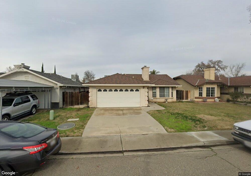
This home is located at 1933 Nimrood Dr, Ceres, CA 95307 and is currently estimated at $412,283, approximately $311 per square foot. 1933 Nimrood Dr is a home located in Stanislaus County with nearby schools including Don Pedro Elementary School, Blaker-Kinser Junior High School, and Central Valley High School.
Ownership History
Date
Name
Owned For
Owner Type
Purchase Details
Closed on
Apr 25, 2005
Sold by
Sanny Mark W and Sanny Carolyn P
Bought by
Sanny Mark W and Sanny Carolyn P
Current Estimated Value
Purchase Details
Closed on
Jun 15, 1995
Sold by
Reynolds Robert William and Reynolds Archie Dean
Bought by
Sanny Mark W and Sanny Carolyn P
Home Financials for this Owner
Home Financials are based on the most recent Mortgage that was taken out on this home.
Original Mortgage
$72,100
Interest Rate
7.88%
Create a Home Valuation Report for This Property
The Home Valuation Report is an in-depth analysis detailing your home's value as well as a comparison with similar homes in the area
Purchase History
| Date | Buyer | Sale Price | Title Company |
|---|---|---|---|
| Sanny Mark W | -- | -- | |
| Sanny Mark W | $106,000 | North American Title Company |
Source: Public Records
Mortgage History
| Date | Status | Borrower | Loan Amount |
|---|---|---|---|
| Closed | Sanny Mark W | $72,100 |
Source: Public Records
Tax History
| Year | Tax Paid | Tax Assessment Tax Assessment Total Assessment is a certain percentage of the fair market value that is determined by local assessors to be the total taxable value of land and additions on the property. | Land | Improvement |
|---|---|---|---|---|
| 2025 | $2,135 | $178,866 | $41,980 | $136,886 |
| 2024 | $2,003 | $175,359 | $41,157 | $134,202 |
| 2023 | $1,948 | $171,921 | $40,350 | $131,571 |
| 2022 | $1,931 | $168,551 | $39,559 | $128,992 |
| 2021 | $1,911 | $165,247 | $38,784 | $126,463 |
| 2020 | $1,852 | $163,554 | $38,387 | $125,167 |
| 2019 | $1,840 | $160,348 | $37,635 | $122,713 |
| 2018 | $1,802 | $157,205 | $36,898 | $120,307 |
| 2017 | $1,787 | $154,124 | $36,175 | $117,949 |
| 2016 | $1,751 | $151,103 | $35,466 | $115,637 |
| 2015 | $1,728 | $148,835 | $34,934 | $113,901 |
| 2014 | $1,693 | $145,920 | $34,250 | $111,670 |
Source: Public Records
Map
Nearby Homes
- 3939 Central Ave Unit 126
- 3939 Central Ave Unit 35
- 3939 Central Ave Unit 178
- 1628 Sungate Dr
- 3816 Dano Ct
- 3005 Willetts Way
- 3501 Soda Canyon Dr
- 1440 Don Pedro Rd
- 2921 5th St
- 3116 Larrynell Dr
- 3816 Teek Ct
- 3632 9th St
- 3608 Cassie Ln
- 2708 Oasis Ave
- 2812 Roswell Way
- 4376 Admiral Ct
- 4396 Admiral Ct
- 2800 Skybrite Dr
- 1279 Montclaire Dr
- 954 Avenida Real
- 1937 Nimrood Dr
- 1929 Nimrood Dr
- 1925 Nimrood Dr
- 1930 Walnut Ave
- 1930 Walnut Ave
- 1921 Nimrood Dr
- 1934 Walnut Ave
- 1936 Nimrood Dr
- 1940 Nimrood Dr
- 1938 Walnut Ave
- 1932 Nimrood Dr
- 1926 Walnut Ave
- 1944 Nimrood Dr
- 1928 Nimrood Dr
- 1917 Nimrood Dr
- 1948 Nimrood Dr
- 1924 Walnut Ave
- 1924 Nimrood Dr
- 1920 Walnut Ave
- 1952 Nimrood Dr
Your Personal Tour Guide
Ask me questions while you tour the home.