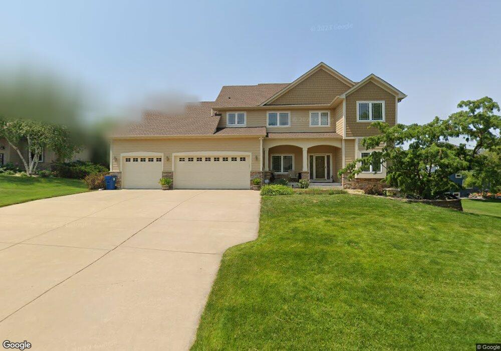
1942 Raspberry Ln Shakopee, MN 55379
Estimated Value: $573,620 - $670,000
4
Beds
3
Baths
3,376
Sq Ft
$184/Sq Ft
Est. Value
About This Home
This home is located at 1942 Raspberry Ln, Shakopee, MN 55379 and is currently estimated at $621,155, approximately $183 per square foot. 1942 Raspberry Ln is a home located in Scott County with nearby schools including Jackson Elementary School, East Middle School, and Shakopee Senior High School.
Ownership History
Date
Name
Owned For
Owner Type
Purchase Details
Closed on
Jul 25, 2023
Sold by
Forrester Todd A and Forrester Kelly L
Bought by
Forrester Todd A and Forrester Kelly L
Current Estimated Value
Purchase Details
Closed on
Jul 7, 2006
Sold by
College City Homes Inc
Bought by
Forrester Kelly L and Forrester Todd A
Create a Home Valuation Report for This Property
The Home Valuation Report is an in-depth analysis detailing your home's value as well as a comparison with similar homes in the area
Home Values in the Area
Average Home Value in this Area
Purchase History
| Date | Buyer | Sale Price | Title Company |
|---|---|---|---|
| Forrester Todd A | -- | None Listed On Document | |
| Forrester Kelly L | $569,693 | -- | |
| College City Homes Inc | $133,900 | -- |
Source: Public Records
Tax History
| Year | Tax Paid | Tax Assessment Tax Assessment Total Assessment is a certain percentage of the fair market value that is determined by local assessors to be the total taxable value of land and additions on the property. | Land | Improvement |
|---|---|---|---|---|
| 2025 | $5,756 | $538,300 | $171,900 | $366,400 |
| 2024 | $5,802 | $538,300 | $171,900 | $366,400 |
| 2023 | $5,912 | $535,000 | $168,600 | $366,400 |
| 2022 | $6,392 | $607,500 | $168,600 | $438,900 |
| 2021 | $5,678 | $501,700 | $138,000 | $363,700 |
| 2020 | $6,214 | $485,500 | $123,500 | $362,000 |
| 2019 | $6,212 | $465,600 | $103,600 | $362,000 |
| 2018 | $6,738 | $0 | $0 | $0 |
| 2016 | $7,124 | $0 | $0 | $0 |
| 2014 | -- | $0 | $0 | $0 |
Source: Public Records
Map
Nearby Homes
- 1790 Colonial St
- 1227 Elmwood Ave Unit 85
- 1724 Weston Ln Unit 84
- 668 Cobblestone Way
- 1022 Providence Dr
- 1646 Liberty Cir
- 1035 Providence Dr
- 849 Providence Dr
- 1562 Liberty Cir Unit 2403
- 236 Ardennes Ave E
- 1063 Langston Ct
- 1820 Mockingbird Ave
- 1819 Mockingbird Ave
- 1284 Meadow Ln S
- 291 Appleblossom Ln
- 216 Arabian Ave W
- 2066 Mockingbird Ave
- 2027 Brittany Ct
- 2039 Brittany Ct
- 326 Braeburn Dr
- 1950 Raspberry Ln
- 1934 Raspberry Ln
- 1168 Patterson Dr
- 1085 Patterson Cir
- 1060 Patterson Cir
- 1142 Patterson Dr
- 1949 Raspberry Ln
- 1941 Raspberry Ln
- 1958 Raspberry Ln
- 1933 Raspberry Ln
- 1957 Raspberry Ln
- 1116 Patterson Dr
- 1925 Raspberry Ln
- 1040 Patterson Cir
- 1065 Patterson Cir
- 1191 Patterson Dr
- 1217 Patterson Dr
- 1965 Raspberry Ln
- 1165 Patterson Dr
- 1090 Patterson Dr
Your Personal Tour Guide
Ask me questions while you tour the home.