
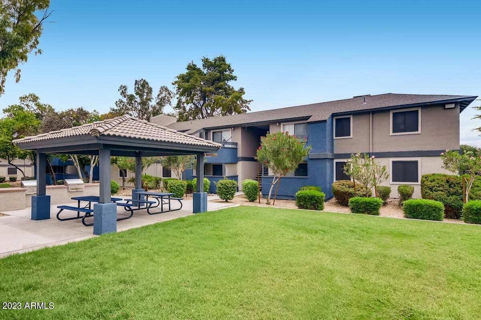


1944 W Thunderbird Rd Unit 2 Phoenix, AZ 85023
North Central Phoenix Neighborhood
2
Beds
2
Baths
910
Sq Ft
675,180
Sq Ft Lot
Highlights
- Fitness Center
- 15.5 Acre Lot
- No HOA
- Thunderbird High School Rated A-
- Clubhouse
- 2-minute walk to Rover Ridge Dog Park
About This Home
Upgrade your living experience at our community in sunny Phoenix, AZ. With stunning, newly renovated homes available, you will love elevated amenities -from upgraded kitchens with glass-tiled backsplash and granite countertops to in-home washers and dryers. All of our homes feature plush carpeted bedrooms, full kitchen appliance packages, spacious walk-in closets, and a patio or balcony. Take advantage of outstanding community offerings, including four resort-style swimming pools, fitness center with free weights and yoga, and dog park.
Condo Details
Home Type
- Condominium
Year Built
- Built in 1979
Parking
- 1 Carport Space
Home Design
- Wood Frame Construction
- Tile Roof
- Stucco
Interior Spaces
- 910 Sq Ft Home
- 2-Story Property
- Blinds
- Formal Dining Room
Kitchen
- Electric Oven
- Electric Range
- Microwave
- Dishwasher
- Disposal
Bedrooms and Bathrooms
- 2 Bedrooms
- 2 Full Bathrooms
Laundry
- Dryer
- Washer
Schools
- Moon Mountain Elementary School
- Desert Foothills Middle School
- Thunderbird High School
Utilities
- Central Air
- Heating Available
Listing and Financial Details
- Property Available on 1/16/26
- $150 Move-In Fee
- 12-Month Minimum Lease Term
- $55 Application Fee
- Tax Lot 2
- Assessor Parcel Number 208-32-336-A
Community Details
Overview
- No Home Owners Association
- Latitude Subdivision
Amenities
- Clubhouse
- Laundry Facilities
Recreation
- Fitness Center
- Fenced Community Pool
- Community Spa
Map
Property History
| Date | Event | Price | List to Sale | Price per Sq Ft |
|---|---|---|---|---|
| 01/16/2026 01/16/26 | Price Changed | $1,254 | -1.0% | $1 / Sq Ft |
| 01/07/2026 01/07/26 | Price Changed | $1,267 | +0.4% | $1 / Sq Ft |
| 11/28/2025 11/28/25 | Price Changed | $1,262 | -0.2% | $1 / Sq Ft |
| 11/26/2025 11/26/25 | Price Changed | $1,264 | -0.4% | $1 / Sq Ft |
| 11/18/2025 11/18/25 | Price Changed | $1,269 | +1.2% | $1 / Sq Ft |
| 10/28/2025 10/28/25 | Price Changed | $1,254 | -0.1% | $1 / Sq Ft |
| 10/24/2025 10/24/25 | Price Changed | $1,255 | +0.4% | $1 / Sq Ft |
| 10/09/2025 10/09/25 | Price Changed | $1,250 | 0.0% | $1 / Sq Ft |
| 10/09/2025 10/09/25 | For Rent | $1,250 | -3.2% | -- |
| 09/08/2025 09/08/25 | Off Market | $1,291 | -- | -- |
| 09/04/2025 09/04/25 | Price Changed | $1,291 | +0.1% | $1 / Sq Ft |
| 08/28/2025 08/28/25 | Price Changed | $1,290 | +4.3% | $1 / Sq Ft |
| 08/21/2025 08/21/25 | Price Changed | $1,237 | -4.2% | $1 / Sq Ft |
| 08/20/2025 08/20/25 | Price Changed | $1,291 | +8.9% | $1 / Sq Ft |
| 08/14/2025 08/14/25 | Price Changed | $1,185 | +5.4% | $1 / Sq Ft |
| 07/13/2025 07/13/25 | Price Changed | $1,124 | +0.4% | $1 / Sq Ft |
| 07/08/2025 07/08/25 | Price Changed | $1,120 | -2.0% | $1 / Sq Ft |
| 07/01/2025 07/01/25 | Price Changed | $1,143 | -2.4% | $1 / Sq Ft |
| 06/29/2025 06/29/25 | Price Changed | $1,171 | -2.8% | $1 / Sq Ft |
| 06/21/2025 06/21/25 | Price Changed | $1,205 | -1.9% | $1 / Sq Ft |
| 06/19/2025 06/19/25 | Price Changed | $1,228 | -1.0% | $1 / Sq Ft |
| 06/14/2025 06/14/25 | Price Changed | $1,240 | -7.4% | $1 / Sq Ft |
| 06/12/2025 06/12/25 | Price Changed | $1,339 | +8.5% | $1 / Sq Ft |
| 06/06/2025 06/06/25 | Price Changed | $1,234 | +0.4% | $1 / Sq Ft |
| 05/30/2025 05/30/25 | Price Changed | $1,229 | +1.0% | $1 / Sq Ft |
| 05/29/2025 05/29/25 | Price Changed | $1,217 | -6.2% | $1 / Sq Ft |
| 05/22/2025 05/22/25 | Price Changed | $1,298 | +1.9% | $1 / Sq Ft |
| 05/20/2025 05/20/25 | Price Changed | $1,274 | +1.0% | $1 / Sq Ft |
| 05/14/2025 05/14/25 | Price Changed | $1,262 | +1.0% | $1 / Sq Ft |
| 05/08/2025 05/08/25 | Price Changed | $1,250 | -2.7% | $1 / Sq Ft |
| 05/06/2025 05/06/25 | Price Changed | $1,285 | +1.8% | $1 / Sq Ft |
| 05/03/2025 05/03/25 | Price Changed | $1,262 | -1.9% | $1 / Sq Ft |
| 04/26/2025 04/26/25 | Price Changed | $1,287 | -9.9% | $1 / Sq Ft |
| 04/23/2025 04/23/25 | Price Changed | $1,428 | +1.6% | $2 / Sq Ft |
| 04/19/2025 04/19/25 | Price Changed | $1,406 | +9.5% | $2 / Sq Ft |
| 04/15/2025 04/15/25 | Price Changed | $1,284 | -1.0% | $1 / Sq Ft |
| 04/11/2025 04/11/25 | Price Changed | $1,297 | -1.1% | $1 / Sq Ft |
| 04/08/2025 04/08/25 | Price Changed | $1,312 | -0.8% | $1 / Sq Ft |
| 04/06/2025 04/06/25 | Price Changed | $1,323 | -0.1% | $1 / Sq Ft |
| 04/04/2025 04/04/25 | Price Changed | $1,324 | +2.0% | $1 / Sq Ft |
| 04/02/2025 04/02/25 | Price Changed | $1,298 | -1.0% | $1 / Sq Ft |
| 03/27/2025 03/27/25 | Price Changed | $1,311 | -2.2% | $1 / Sq Ft |
| 03/21/2025 03/21/25 | Price Changed | $1,341 | +2.0% | $1 / Sq Ft |
| 03/18/2025 03/18/25 | Price Changed | $1,315 | +1.0% | $1 / Sq Ft |
| 03/14/2025 03/14/25 | Price Changed | $1,302 | +1.2% | $1 / Sq Ft |
| 03/11/2025 03/11/25 | Price Changed | $1,287 | -2.2% | $1 / Sq Ft |
| 03/09/2025 03/09/25 | Price Changed | $1,316 | +1.2% | $1 / Sq Ft |
| 03/06/2025 03/06/25 | Price Changed | $1,300 | -1.4% | $1 / Sq Ft |
| 03/04/2025 03/04/25 | Price Changed | $1,318 | +1.0% | $1 / Sq Ft |
| 03/02/2025 03/02/25 | Price Changed | $1,305 | -0.6% | $1 / Sq Ft |
| 02/27/2025 02/27/25 | Price Changed | $1,313 | +2.0% | $1 / Sq Ft |
| 02/20/2025 02/20/25 | Price Changed | $1,287 | +2.0% | $1 / Sq Ft |
| 02/15/2025 02/15/25 | Price Changed | $1,262 | +1.0% | $1 / Sq Ft |
| 02/12/2025 02/12/25 | Price Changed | $1,250 | +1.2% | $1 / Sq Ft |
| 02/06/2025 02/06/25 | Price Changed | $1,235 | -4.6% | $1 / Sq Ft |
| 02/01/2025 02/01/25 | Price Changed | $1,295 | -1.9% | $1 / Sq Ft |
| 01/30/2025 01/30/25 | Price Changed | $1,320 | -0.1% | $1 / Sq Ft |
| 01/24/2025 01/24/25 | Price Changed | $1,321 | -2.0% | $1 / Sq Ft |
| 01/14/2025 01/14/25 | Price Changed | $1,348 | +0.7% | $1 / Sq Ft |
| 12/20/2024 12/20/24 | Price Changed | $1,339 | +0.9% | $1 / Sq Ft |
| 12/18/2024 12/18/24 | Price Changed | $1,327 | +2.0% | $1 / Sq Ft |
| 12/13/2024 12/13/24 | Price Changed | $1,301 | -1.0% | $1 / Sq Ft |
| 12/11/2024 12/11/24 | Price Changed | $1,314 | +1.9% | $1 / Sq Ft |
| 12/09/2024 12/09/24 | Price Changed | $1,290 | +1.7% | $1 / Sq Ft |
| 12/06/2024 12/06/24 | Price Changed | $1,269 | +0.2% | $1 / Sq Ft |
| 12/05/2024 12/05/24 | Price Changed | $1,266 | +1.0% | $1 / Sq Ft |
| 12/02/2024 12/02/24 | Price Changed | $1,254 | +6.4% | $1 / Sq Ft |
| 11/23/2024 11/23/24 | Price Changed | $1,179 | -0.7% | $1 / Sq Ft |
| 10/28/2024 10/28/24 | Price Changed | $1,187 | +2.1% | $1 / Sq Ft |
| 10/21/2024 10/21/24 | Price Changed | $1,163 | -5.0% | $1 / Sq Ft |
| 10/17/2024 10/17/24 | Price Changed | $1,224 | -0.8% | $1 / Sq Ft |
| 10/11/2024 10/11/24 | Price Changed | $1,234 | -5.0% | $1 / Sq Ft |
| 10/09/2024 10/09/24 | Price Changed | $1,299 | -5.7% | $1 / Sq Ft |
| 09/19/2024 09/19/24 | Price Changed | $1,378 | +2.3% | $2 / Sq Ft |
| 09/05/2024 09/05/24 | Price Changed | $1,347 | +2.1% | $1 / Sq Ft |
| 08/31/2024 08/31/24 | Price Changed | $1,319 | +6.4% | $1 / Sq Ft |
| 08/22/2024 08/22/24 | Price Changed | $1,240 | -2.8% | $1 / Sq Ft |
| 08/06/2024 08/06/24 | Price Changed | $1,276 | -2.0% | $1 / Sq Ft |
| 08/01/2024 08/01/24 | Price Changed | $1,302 | -9.2% | $1 / Sq Ft |
| 07/26/2024 07/26/24 | Price Changed | $1,434 | +17.8% | $2 / Sq Ft |
| 07/18/2024 07/18/24 | Price Changed | $1,217 | -12.5% | $1 / Sq Ft |
| 07/16/2024 07/16/24 | Price Changed | $1,391 | +17.9% | $2 / Sq Ft |
| 07/12/2024 07/12/24 | Price Changed | $1,180 | +2.7% | $1 / Sq Ft |
| 07/04/2024 07/04/24 | Price Changed | $1,149 | -5.4% | $1 / Sq Ft |
| 06/27/2024 06/27/24 | Price Changed | $1,214 | -11.2% | $1 / Sq Ft |
| 06/25/2024 06/25/24 | Price Changed | $1,367 | +11.4% | $2 / Sq Ft |
| 06/24/2024 06/24/24 | Price Changed | $1,227 | -1.0% | $1 / Sq Ft |
| 06/19/2024 06/19/24 | Price Changed | $1,239 | -12.9% | $1 / Sq Ft |
| 06/14/2024 06/14/24 | Price Changed | $1,422 | +9.5% | $2 / Sq Ft |
| 06/06/2024 06/06/24 | Price Changed | $1,299 | +0.1% | $1 / Sq Ft |
| 05/30/2024 05/30/24 | Price Changed | $1,298 | -8.4% | $1 / Sq Ft |
| 05/22/2024 05/22/24 | Price Changed | $1,417 | -3.5% | $2 / Sq Ft |
| 05/16/2024 05/16/24 | Price Changed | $1,469 | -10.6% | $2 / Sq Ft |
| 05/09/2024 05/09/24 | Price Changed | $1,643 | +16.4% | $2 / Sq Ft |
| 05/02/2024 05/02/24 | Price Changed | $1,412 | +10.7% | $2 / Sq Ft |
| 04/25/2024 04/25/24 | Price Changed | $1,275 | -22.4% | $1 / Sq Ft |
| 04/03/2024 04/03/24 | Price Changed | $1,643 | +33.7% | $2 / Sq Ft |
| 03/14/2024 03/14/24 | Price Changed | $1,229 | -10.2% | $1 / Sq Ft |
| 03/02/2024 03/02/24 | Price Changed | $1,369 | -4.8% | $2 / Sq Ft |
| 02/24/2024 02/24/24 | Price Changed | $1,438 | -5.2% | $2 / Sq Ft |
| 02/10/2024 02/10/24 | Price Changed | $1,517 | +12.8% | $2 / Sq Ft |
| 01/27/2024 01/27/24 | Price Changed | $1,345 | +3.4% | $1 / Sq Ft |
| 01/25/2024 01/25/24 | Price Changed | $1,301 | -2.2% | $1 / Sq Ft |
| 01/19/2024 01/19/24 | Price Changed | $1,330 | -6.0% | $1 / Sq Ft |
| 01/09/2024 01/09/24 | Price Changed | $1,415 | -0.8% | $2 / Sq Ft |
| 01/03/2024 01/03/24 | Price Changed | $1,426 | +5.9% | $2 / Sq Ft |
| 12/27/2023 12/27/23 | Price Changed | $1,347 | -0.3% | $1 / Sq Ft |
| 12/23/2023 12/23/23 | Price Changed | $1,351 | +3.5% | $1 / Sq Ft |
| 12/13/2023 12/13/23 | Price Changed | $1,305 | +10.4% | $1 / Sq Ft |
| 12/09/2023 12/09/23 | Price Changed | $1,182 | -3.4% | $1 / Sq Ft |
| 12/06/2023 12/06/23 | Price Changed | $1,223 | -2.1% | $1 / Sq Ft |
| 12/05/2023 12/05/23 | Price Changed | $1,249 | +0.2% | $1 / Sq Ft |
| 12/03/2023 12/03/23 | Price Changed | $1,246 | -2.0% | $1 / Sq Ft |
| 12/01/2023 12/01/23 | Price Changed | $1,272 | +2.1% | $1 / Sq Ft |
| 11/30/2023 11/30/23 | Price Changed | $1,246 | -14.0% | $1 / Sq Ft |
| 11/25/2023 11/25/23 | Price Changed | $1,449 | -2.8% | $2 / Sq Ft |
| 11/18/2023 11/18/23 | Price Changed | $1,490 | +1.8% | $2 / Sq Ft |
| 11/17/2023 11/17/23 | Price Changed | $1,463 | +19.8% | $2 / Sq Ft |
| 11/14/2023 11/14/23 | Price Changed | $1,221 | -5.3% | $1 / Sq Ft |
| 11/06/2023 11/06/23 | Price Changed | $1,290 | -5.5% | $1 / Sq Ft |
| 10/31/2023 10/31/23 | Price Changed | $1,365 | +4.2% | $2 / Sq Ft |
| 10/30/2023 10/30/23 | Price Changed | $1,310 | -0.9% | $1 / Sq Ft |
| 10/26/2023 10/26/23 | Price Changed | $1,322 | -2.1% | $1 / Sq Ft |
| 10/23/2023 10/23/23 | Price Changed | $1,351 | +1.0% | $1 / Sq Ft |
| 10/20/2023 10/20/23 | Price Changed | $1,337 | +1.5% | $1 / Sq Ft |
| 10/19/2023 10/19/23 | Price Changed | $1,317 | -1.8% | $1 / Sq Ft |
| 10/17/2023 10/17/23 | Price Changed | $1,341 | +1.8% | $1 / Sq Ft |
| 10/16/2023 10/16/23 | Price Changed | $1,317 | -0.7% | $1 / Sq Ft |
| 10/14/2023 10/14/23 | Price Changed | $1,326 | -4.0% | $1 / Sq Ft |
| 10/13/2023 10/13/23 | Price Changed | $1,381 | -0.1% | $2 / Sq Ft |
| 10/12/2023 10/12/23 | Price Changed | $1,382 | 0.0% | $2 / Sq Ft |
| 10/12/2023 10/12/23 | For Rent | $1,382 | -4.2% | -- |
| 10/12/2023 10/12/23 | Off Market | $1,442 | -- | -- |
| 10/06/2023 10/06/23 | Price Changed | $1,442 | -0.6% | $2 / Sq Ft |
| 10/03/2023 10/03/23 | Price Changed | $1,451 | +9.3% | $2 / Sq Ft |
| 09/28/2023 09/28/23 | Price Changed | $1,327 | -0.7% | $1 / Sq Ft |
| 09/27/2023 09/27/23 | Price Changed | $1,336 | -3.7% | $1 / Sq Ft |
| 09/25/2023 09/25/23 | Price Changed | $1,387 | -0.6% | $2 / Sq Ft |
| 09/22/2023 09/22/23 | Price Changed | $1,396 | -5.7% | $2 / Sq Ft |
| 09/19/2023 09/19/23 | Price Changed | $1,480 | +9.8% | $2 / Sq Ft |
| 09/16/2023 09/16/23 | Price Changed | $1,348 | -10.3% | $1 / Sq Ft |
| 09/15/2023 09/15/23 | Price Changed | $1,502 | +1.7% | $2 / Sq Ft |
| 09/14/2023 09/14/23 | Price Changed | $1,477 | -1.0% | $2 / Sq Ft |
| 09/13/2023 09/13/23 | Price Changed | $1,492 | +2.9% | $2 / Sq Ft |
| 09/11/2023 09/11/23 | Price Changed | $1,450 | -0.7% | $2 / Sq Ft |
| 08/30/2023 08/30/23 | Price Changed | $1,460 | +3.0% | $2 / Sq Ft |
| 08/29/2023 08/29/23 | Price Changed | $1,418 | -0.1% | $2 / Sq Ft |
| 08/28/2023 08/28/23 | Price Changed | $1,420 | -2.1% | $2 / Sq Ft |
| 08/23/2023 08/23/23 | For Rent | $1,451 | -- | -- |
Source: Arizona Regional Multiple Listing Service (ARMLS)
About the Listing Agent
Our team at Apartment & Home Solutions offers FREE unparalleled service to all clients in the Phoenix, Arizona rental real estate market.
With over 25 years experience; this is our expertise! No more headaches; we’ve simplified the leasing process and assisted hundreds of renters in widely different circumstances find the right fit.
We proudly represent over 400 rental listings; We're confident we'll find you the perfect rental to call home.
Looking to sell or purchase? We
Pete's Other Listings
Source: Arizona Regional Multiple Listing Service (ARMLS)
MLS Number: 6596095
APN: 208-32-336A
Disclaimer: Certain information contained herein is derived from information provided by parties other than Homes.com. All information provided is deemed reliable, but is not guaranteed to be accurate and should be independently verified.
![]() All information should be verified by the recipient and none is guaranteed as accurate by ARMLS
All information should be verified by the recipient and none is guaranteed as accurate by ARMLS
Listing Information presented by local MLS brokerage: Ten-X, local REALTOR®- Arlene Richardson - (888)-952-6393
Nearby Homes
- 14203 N 19th Ave Unit 1055
- 14203 N 19th Ave Unit 1038
- 14203 N 19th Ave Unit 1018
- 14203 N 19th Ave Unit 2040
- 2148 W Sharon Ave
- 13618 N 21st Dr
- 1930 W Joan de Arc Ave
- 2143 W Eugie Ave
- 2049 W Joan de Arc Ave
- 1633 W Evans Dr
- 2158 W Willow Ave
- 13039 N 19th Ave
- 2404 W Rue de Lamour Ave
- 2424 W Redfield Rd
- 2355 W Voltaire Ave
- 13150 N 22nd Ave
- 13431 N 24th Ave
- 2440 W Rue de Lamour Ave
- 1722 W Saint Moritz Ln
- 13607 N 24th Ln
- 1944 W Thunderbird Rd Unit 1
- 1944 W Thunderbird Rd
- 2140 W Thunderbird Rd
- 14203 N 19th Ave Unit 2007
- 14203 N 19th Ave Unit 1004
- 14203 N 19th Ave Unit 1049
- 14203 N 19th Ave Unit 2051
- 14203 N 19th Ave Unit 2058
- 14602 N 19th Ave
- 1641 W Evans Dr
- 2414 W Redfield Rd
- 1817 W Wood Dr
- 13321 N 26th Ave
- 13249 N 14th Dr
- 14852 N 24th Dr Unit 9
- 14837 N 25th Dr Unit 13
- 1502 W Port au Prince Ln Unit 2
- 2415 W Greenway Rd Unit 3
- 12440 N 19th Ave
- 14425 N Coral Gables Dr
Your Personal Tour Guide
Ask me questions while you tour the home.